Signal No. 2 up over areas in Luzon with 'Pepito' now a tropical storm
MANILA, Philippines — Parts of Luzon are now under Tropical Cyclone Wind Signal No. 2 with tropical storm Pepito now firmly over the Luzon landmass, weather forecasters said Tuesday.
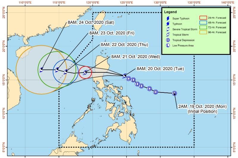
In its latest weather bulletin 11 a.m. on Tuesday, state weather bureau PAGASA said that Pepito was last seen 295 kilometers east of Baler, Aurora at 10 a.m., moving northwestward at 25 kilometers per hour.
Pepito was also measured carrying winds of greater than 61 kph, with PAGASA warning that these may intensify further and peak up to 120 kph in at least 24 hours until possibly reaching severe tropical storm category by Thursday.
Signal No. 2 has been hoisted over the following areas:
- La Union
- Ifugao
- Benguet
- Nueva Vizcaya
- Quirino
- Pangasinan
- Nueva Ecija
- Tarlac
- Aurora
- southern portion of Isabela (Palanan, San Mariano, Benito Soliven, Naguilian, Gamu, Burgos, San Manuel, Aurora, Cabatuan, Luna, Reina Mercedes, Cauayan City, Dinapigue, San Guillermo, Angadanan, Alicia, San Mateo, Ramon, San Isidro, Echague, San Agustin, Jones, Santiago City, Cordon)
- southern portion of Ilocos Sur (Sugpon, Alilem, Tagudin)
- northern portion of Zambales (Iba, Palauig, Masinloc, Candelaria, Santa Cruz, Botolan, Cabangan)
- northern portion of Quezon (General Nakar)
For areas under Signal No. 2, tropical cyclone will affect the locality while high to gale-force winds greater than 61 kph and up to 120 kph may be expected in at least 24 hours, PAGASA warned.
"It will then cross the Luzon landmass, and emerge over the West Philippine Sea tomorrow morning. This tropical cyclone may exit the Philippine Area of Responsibility (PAR) on Thursday morning," PAGASA's report read.
"Light to moderate with at times heavy rains will be experienced over Metro Manila and the rest of Luzon, Western Visayas, Zamboanga Peninsula, and Bangsamoro," it also said.
Gale Warning is in effect over the seaboards of Batanes, Cagayan, and Ilocos Norte, indicating areas where sea travel is significantly risky due to rough to very rough seas, according to PAGASA.
Signal No. 1 is also over the following areas:
- Abra
- Kalinga
- Mountain Province
- Bulacan,Pampanga,
- Bataan,Metro Manila,
- Rizal,
- northern portion of Camarines Norte (Paracale, Jose Panganiban, Capalonga, Vinzons),
- Catanduanes,
- rest of the northern portion of Quezon (Infanta, Real)
- rest of Zambales
In these areas, PAGASA said, high to gale-force winds of 30-60 kph may be expected in at least 36 hours or intermittent rains may be expected within 36 hours.
Forecast positions
- Wednesday morning: 155 km West of Dagupan City, Pangasinan (16.1 °N, 118.9 °E)
- Thursday morning: 465 km West of Dagupan City, Pangasinan (16.2 °N, 116.0 °E)
- Friday morning: 605 km West of Dagupan City, Pangasinan (outside PAR) ( 16.5 °N, 114.7 °E)
- Saturday morning: 850 km West of Northern Luzon (outside PAR) (16.5 °N, 112.4 °E)
— Franco Luna


- Latest
- Trending