


Living in the round

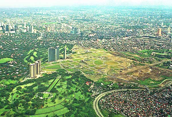
Bonifacio Global City in the 1990s was still circular in geometry.
Most Filipinos live in towns and cities. Urban life is now the norm but our history of urban life started close to four centuries ago. The Spanish introduced us to urbanity as a way to control us.
We were brought into poblacions, which were organized according to the Laws of the Indies. Generally, this template stipulated that we build using a grid of streets with plazas and open spaces. These were framed by important structures of church and state.
Most of the Philippines’ 145 cities and close to 1,500 towns are shaped this way. There are exceptions. Circular patterns have appeared in our towns and cities, but these have been used to define singular elements, like the two cemeteries in Manila, from the Spanish period. Paco Park and Remedios Circle were once cemeteries before they were both converted to parks. There is also the post-war American Cemetery.
The old Bilibid prison was circular with its buildings arranged as spokes on a wheel. This configuration was called a panopticon, a Western invention applied to prisons to guarantee inmates were always kept under watch from a central hub.
Then there were, of course, the many rotundas of Metro Manila, which were removed from the 1960s to make way for increased traffic. Only one “circle” has survived. This is the Quezon Memorial Circle. Actually an ellipse, this huge roundabout was, in fact, originally designed in 1941 as the location for the Philippine Legislative Complex.
After the war, the ellipse turned into a memorial for President Quezon. Although the Quezon Memorial was laid out as the focal point of Quezon City, the districts around it were still laid out in a grid with wide avenues connecting it to the ellipse.
There have been only two urban plans that I know, that have taken a circular, or polygonal form. One was in the early American period. The other was laid out by an American planning firm for a modern CBD. The first has persisted in its original geometry while the other had to be reconfigured to a more acceptable form.
Santa is a town just a few kilometers south of Vigan City in Ilocos Sur. The highway bypasses the town center so people don’t realize how distinctive the town’s urban plan is.
The town was founded in 1576 as a satellite of the larger town of Vigan nearby. It played a minor role in the province’s history, involving itself in failed revolts against Spain. The town was economically healthy but its location beside the mighty Abra River led it to be prone to flooding and erosion of a large chunk of its productive agricultural land.
Santa was moved twice, each after devastating floods in 1852 and 1905. The last time was early in the American period, when it found a home at the foothills of Cordilleras.
Instead of following the Spanish pattern of a grid organized around a plaza, the new Santa was laid out in a circle with a diameter of about 700 meters. Eight spokes radiate from a central plaza and civic center, which covers about a hectare and a half. Four ring roads are defined by this pattern, which lasts to this day.
I visited the unique town recently. Its distinctive century-old network of streets is intact, albeit paved today in modern concrete. The town was saved from the fate of many other provincial towns — that of being bisected by the national road since the highway skirted the town’s edge.
In the middle of the town’s historic center is its church, named after its patron Santa Catalina de Alexandria. The town also took its name from the saint, although it was shortened to the extreme.
The town’s plaza and a small number of heritage homes are intact. Although nowhere near as many as Vigan’s structures, I’m sure Santa’s heritage structures do have a story to tell.
There’s not much to see or visit in town aside from its unique pattern. The town does host two national parks — the Northern Luzon Heroes Hill National Park and the Gabriela Silang Memorial Park. The former is huge, with over 1,300 hectares or over 20 times the size of Rizal Park. Gabriela Silang’s is more modest. In addition to these two attractions, there are the Banaoang View Deck and the two Quirino Bridges.
Aside from Santa, the only other urban center I know that took a circular pattern was Bonifacio Global City. When it was first planned, the area that was formerly Camp Bonifacio was reshaped into a wide expanse of open land connected by a series of concentric circles. The American firm tasked to design it apparently took inspiration from the American Cemetery’s geometry.
BGC’s geometry proved problematic. Property sales were hindered in the late 1990s by the Asian crash, but in the succeeding decade, it was by the fact that few buyers wanted pie-shaped lots. When BGC changed hands, the new owners decided to reconfigure the district into a regular grid, with a central spine running down the middle.
The strategy worked, proving that life in the round may be useful for singular urban elements or small towns, but our large cities and metropolises need to follow the efficient grid.
For cities, therefore, it’s still hip to be square. Cities like New York, Barcelona, San Francisco have proven this. Of course, they also have good train systems. BGC is on the right track, although it still leaves much to be desired in terms of public squares or a network of parks in proportion to its population.
* * *
Feedback is welcome. Please email the writer at paulo.alcazaren@gmail.com.


