Signal No. 1 up due to Kabayan
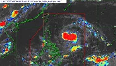
MANILA, Philippines — The low-pressure area spotted east of Surigao del Sur has developed into Tropical Depression Kabayan, the 11th cyclone to enter the country this year, according to state weather bureau Philippine Atmospheric, Geophysical and Astronomical Services Administration (PAGASA).
Kabayan (international name Jelawat) is expected to make landfall either in Davao Oriental or Surigao del Sur, which was recently hit by a magnitude 7.4 earthquake, PAGASA assistant weather services chief Chris Perez said at a press conference.
“Kabayan is expected to make landfall either tonight (Sunday night) or tomorrow morning (Monday morning) and those affected should prepare, including those with warning signals,” Perez said.
In Visayas, tropical cyclone wind signal No. 1 was raised in the southern portion of Samar (Basey, Santa Rita, Marabut, Talalora, Villareal and Pinabacdao); southern portion of Eastern Samar (Maydolong, Borongan City, Quinapondan, Guiuan, Lawaan, Balangiga, Llorente, Giporlos, Salcedo, Balangkayan, General Macarthur, Hernani and Mercedes); Leyte, Southern Leyte, Bohol and Camotes Islands.
Signal No. 1 was also raised in Mindanao, in Dinagat Islands; Surigao del Norte; Surigao del Sur; Agusan del Norte; Agusan del Sur; northern portion of Davao Oriental (Cateel, Boston and Baganga); northern portion of Davao de Oro (Monkayo, Laak); Misamis Oriental; Camiguin and northern portion of Bukidnon (Impasug-Ong, Malitbog, Manolo Fortich, Sumilao, Libona, Baungon, Cabanglasan and Malaybalay City).“The center of Tropical Depression Kabayan was estimated at 440 kilometers east of Davao City with maximum sustained winds of 55 km per hour near the center, gustiness of up to 70 km per hour as it is moving north-northwestward slowly,” Perez added.
Kabayan would eventually reach Palawan before leaving the Philippine area of responsibility.
“By Tuesday, Tropical Depression Kabayan will be over the coastal waters of Palawan, and then by Wednesday, it will be 125 kilometers of Pagasa Island and by Thursday, it will exit PAR and will be located at the West Philippine Sea,” Perez reported.
At least 100 to 200 millimeters of rainfall are expected in Surigao del Sur, Surigao del Norte, Dinagat Island and Southern Leyte while at least 50 to 100 millimeters of rain will affect Eastern Visayas, Davao region, Northern Mindanao and the rest of Caraga region.
“Flooding and rain-induced landslides are likely especially in areas that are highly susceptible and experienced considerable amounts of rainfall for the past several days,” he said.
Perez added that aside from Kabayan, the shear line will also bring rain to the Southern Luzon area.
“Today and until tomorrow (Monday), we expect between 50 to 100 millimeters of rain in the Bicol region,” he noted.
PAGASA administrator Nathaniel Servando said that areas affected by the recent magnitude 7.4 quake in Mindanao should take necessary precautions. — Evelyn Macairan


- Latest
- Trending