More areas in Southern Luzon, Eastern Visayas under Signal No. 1 due to ‘Ulysses’
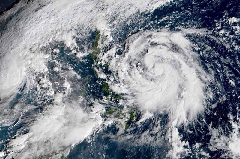
MANILA, Philippines — The state weather bureau placed more areas in Southern Luzon and Eastern Visayas under Signal No. 1 as Tropical Storm Ulysses (international name: Vamco) slowed down while approaching land.
Ulysses was located 555 kilometers east of Virac, Catanduanes bearing peak winds of 65 kph near the center and gusts of up to 80 kph. PAGASA said it is forecast to strengthen into a severe tropical storm Tuesday evening.
Ulysses may reach typhoon category by Wednesday morning and attain its peak intensity of 140 to 155 kph Wednesday afternoon or evening.
PAGASA hoisted Tropical Cyclone Wind Signal No. 1 (winds between 30 and 60 kph expected in at least 36 hours) over the following areas in Calabarzon, Bicol region and Eastern Visayas:
- Catanduanes
- Camarines Norte
- Camarines Sur
- Albay
- Sorsogon
- Eastern portion of Masbate (Aroroy, Pio V. Corpuz, Cataingan, Palanas, Uson, Dimasalang, Masbate City, Mobo, Baleno) including Ticao and Burias Islands
- Southeastern portion of Quezon (Guinayangan, Tagkawayan, Buenavista, San Andres, San Narciso)
- Northern Samar
- Northern portion of Samar (Santo Nino, Almagro, Tagapul-An, Tarangnan, Calbayog City, Santa Margarita, Gandara, Pagsanghan, San Jorge, San Jose de Buan, Matuguinao), and the northern portion of Eastern Samar (Maslog, Dolores, Oras, San Policarpo, Arteche, Jipapad)
Residents of these areas will experience strong breeze to near gale conditions due to the tropical storm.
“We are asking those who live in these areas to prepare as Ulysses approaches,” PAGASA weather specialist Meno Mendoza said.
TCWS No. 2 may be raised in some areas of the Bicol region as early as Tuesday night. Based on PAGASA’s projection, the highest wind signal to be hoisted during the passage of Ulysses will be TCWS No. 3.
The tropical storm will dump light to moderate with at times heavy rains over Aurora, Quezon, Bicol region, Eastern Visayas, Caraga and Davao region. Meanwhile, moderate to heavy rains associated with the rainbands of Ulysses will begin affecting Bicol region and portions of Eastern Visayas Wednesday morning.
Ulysses will also bring rough to very rough seas (2.5 to 4.5 meters) over the seaboards of areas under TCWS, Aurora, northern Quezon, and the eastern seaboard of Eastern Samar, making sea travel risky, especially for those will small vessels.
Landfall
Ulysses is moving northwestward Tuesday, then head westward Wednesday.
PAGASA projected that the storm’s center may make landfall over Quezon province Thursday with a close approach in Catanduanes and Camarines Norte—areas badly hit by Super Typhoon Rolly.
“However, the slight shift in the orientation of the track forecast shows an increasing likelihood of landfall over Bicol Region tomorrow afternoon or evening,” weather forecasters said.
It is “highly likely” that Ulysses will crash into land at or near peak intensity.
Forecast positions
- Wednesday morning: 280 km northeast of Virac, Catanduanes
- Thursday morning: 60 km west northwest of Daet, Camarines Norte or 60 km east northeast of Alabat, Quezon
- Friday morning: 370 km west of Sangley Point, Cavite City, Cavite
- Saturday morning: 820 km west of Southern Luzon (outside PAR)
- Sunday morning: 1,090 km west of Central Luzon (outside PAR)
— Gaea Katreena Cabico


- Latest
- Trending