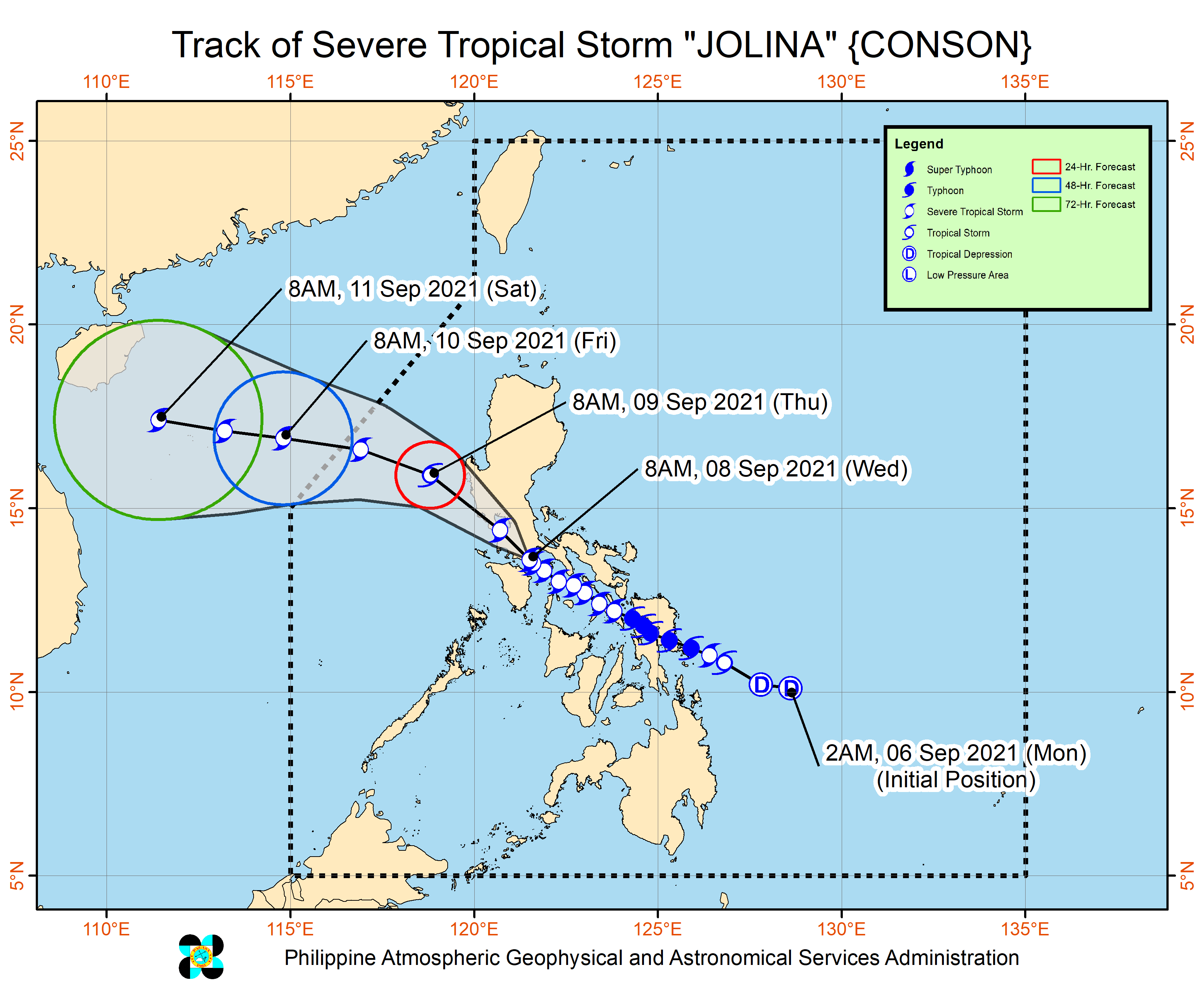
'Jolina' makes landfall in Batangas, 'Kiko' slightly intensifies
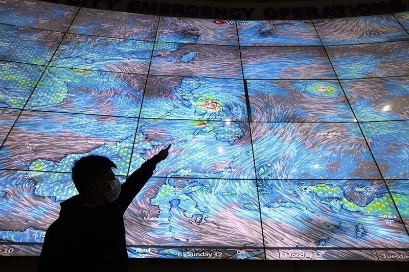
MANILA, Philippines — Severe Tropical Storm "Jolina" made its eighth landfall in the country over San Juan in Batangas on Wednesday while Typhoon "Kiko" slightly intensified, PAGASA said.
The weather bureau in its latest bulletin said Jolina was last seen in the vinicity of Rosario, Batangas.
Jolina remains with 95 kilometers per hour peak winds and gusts of up to 130 kph. The storm continues to move northwestward at a speed of 10 kph.
As of 11 a.m. of September 8, these areas are under PAGASA's Tropical Cyclone Wind Signals:
TCWS No. 2
(Damaging gale-force to storm-force winds prevailing or expected within 24 hours)
- Marinduque
- northern and central portions of Oriental Mindoro (Bansud, Gloria, Pinamalayan, Pola, Socorro, Victoria, Puerto Galera, San Teodoro, Baco, City of Calapan, Naujan)
- northern and central portions of Occidental Mindoro (Abra de Ilog, Paluan, Mamburao, Santa Cruz, Sablayan) including Lubang Islands
- central and southern portions of Quezon (General Luna, Macalelon, Sampaloc, Unisan, Pagbilao, Sariaya, Alabat, Pitogo, City of Tayabas, Padre Burgos, Lucban, Gumaca, Agdangan, Plaridel, San Antonio, Candelaria, Atimonan, Quezon, Tiaong, Mauban, Perez, Lucena City, Dolores, Real, Infanta)
- Batangas
- Cavite
- Laguna
- Rizal
- Metro Manila
- southern portion of Bulacan (Pandi, Bulacan, Marilao, Calumpit, Norzagaray, Plaridel, Santa Maria, Balagtas, Bocaue, Bustos, City of Malolos, Angat, Obando, City of San Jose del Monte, Pulilan, City ofMeycauayan, Hagonoy, Paombong, Guiguinto, San Rafael, Baliuag)
- Pampanga
- Bataan
- Zambales
- Tarlac
TCWS No. 1
(Strong winds prevailing or expected within 36 hours)
- La Union
- southern portion of Benguet (Sablan, Tublay, Bokod, La Trinidad, Baguio City, Itogon, Tuba, Kapangan, Atok)
- southern portion of Nueva Vizcaya (Alfonso Castaneda, Dupax del Norte, Dupax del Sur, Aritao, Santa Fe,
- Kayapa)
- southern portion of Aurora (Baler, Maria Aurora, San Luis, Dingalan)
- Pangasinan
- Nueva Ecija
- rest of Bulacan
- rest of Quezon including Polillo Islands
- Camarines Norte
- western portion of Camarines Sur (Ragay, Del Gallego, Lupi, Sipocot, Cabusao, Libmanan, Pasacao,
- Pamplona)
- western portion of Romblon (Odiongan, Romblon, Banton, Santa Maria, Concepcion, San Andres, San Jose, Looc, Ferrol, Alcantara, San Agustin, Calatrava, Corcuera, Santa Fe)
- rest of Oriental Mindoro
- rest of Occidental Mindoro
What to expect
Jolina will bring heavy to intense with at times torrential rains in the next 24 hours over:
- Metro Manila
- Bataan
- Marinduque
- Cavite
- Laguna
- Batangas
- Rizal
- Quezon
- Occidental Mindoro
- Oriental Mindoro
Moderate to heavy with at times intense rains, meanwhile, will be experienced over:
- Aurora
- Bulacan
- Nueva Ecija
- Pampanga
- Tarlac
- Zambales
- Camarines Sur
- Camarines Norte
- Romblon
- Marinduque
- northern portion of Palawan including Calamian and Cuyo Islands
- Aklan
- Antique
- Capiz
- Iloilo
- Guimaras
- Negros Occidental
PAGASA said Ilocos Region, Cordillera Administrative Region, and Cagayan Valley would in turn see light to moderate with at times heavy rains.
It added the threat of a storm surge of up to 1 meter remains over several coastal areas of Oriental Mindoro, Batangas, and Quezon Province.
After its eight landfall, Jolina will now cross the Batangas-Cavite area before emerging over Manila Bay. It will then make another landfall, this time in the vicinity of Bataan Peninsula.
It is forecast to exit the country on Thursday evening or early Friday morning.
Forecast Position
- Thursday morning: 165 km west of Dagupan City, Pangasinan
- Friday morning: 620 km west of Baguio City, Benguet (outside PAR)
- Saturday morning: 955 km west of Northern Luzon (outside PAR)
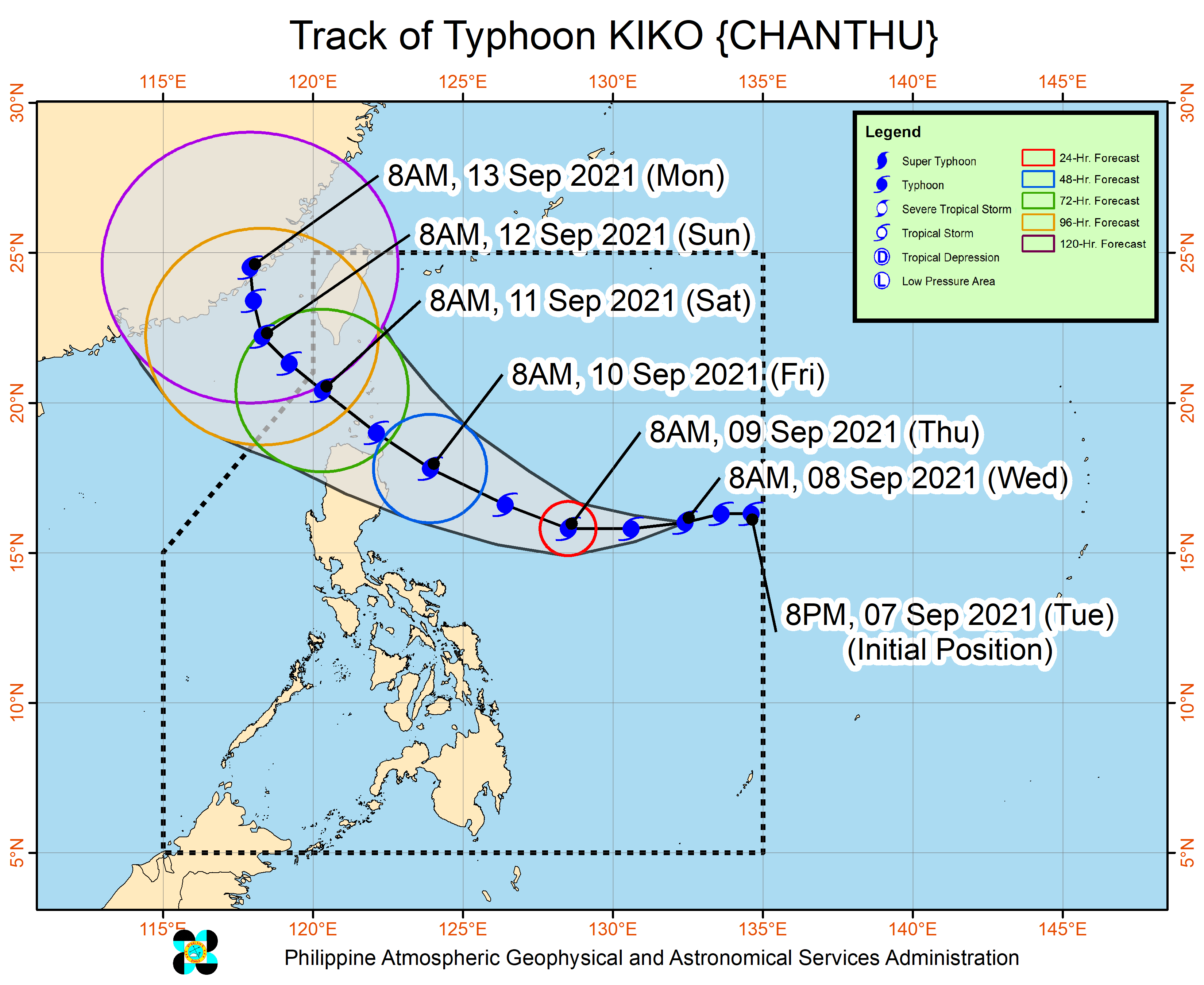
'Kiko' seen to bring strong winds to N. Luzon
PAGASA said Kiko (Chanthu) was last seen at 1,120 kilometers east of Central Luzon.
It now packs 155 kilometers per hour peak winds, and gusts of up to 190 kph. The storm is moving west southwestward over the Philippine Sea at a speed of 20 kph, PAGASA added.
There is no tropical cyclone wind signal in effect yet due to Kiko, but the agency warned heavy rains associated with it could begin affecting the eastern section of Northern Luzon by Friday, September 10.
"Current track and intensity forecast shows there is a moderate to high likelihood that TCWS will be hoisted for several provinces in Northern Luzon, with higher wind signal levels possible over Extreme Northern Luzon," PAGASA said.
It added wind signals could be raised in areas of Northern Luzon starting Wednesday night or Thursday morning, and the highest possible is Signal No. 4.
Kiko is seen to keep moving west southwestward in the next 12 hours. It will turn west northwestward until Friday towards the vicinity of Extreme Northern Luzon.
PAGASA's monitoring indicated the typhoon may be out of the Philippine Area of Responsibility by morning of Sunday, September 12.
Forecast Position
- Thursday morning: 970 km east of Central Luzon
- Friday morning: 230 km east of Tuguegarao City, Cagayan
- Saturday morning: 170 km west southwest of Itbayat, Batanes
- Sunday morning: 400 km west northwest of Itbayat, Batanes (outside PAR)


- Latest
- Trending