


Sacred sites and sightlines

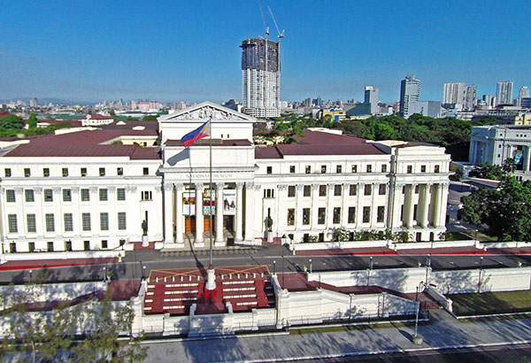
The building of a 49-story condominium within sight of the Rizal monument has generated much controversy and debate. Public opprobrium swelled as the tower rose higher and higher. Heritage advocates and the Knights of Rizal contend the tower compromises the cultural and visual sanctity of the monument and park. Some sectors, however, believe the tower should be allowed completion; otherwise, this may throw a wet blanket over future investment in real estate, affecting the urban economy and progress in general.
The Rizal monument and its surrounding green make up a distinctive mise en scene that defines the genus loci of historic Manila. The site’s geographical and cultural history can give complete context and shed light on arguments against the rising tower, and ultimately on the problems that stem from rapid high-density urban development.
The physical genesis of the Rizal Park and its axial geometry lie in the original open space outside Intramuros. This area was cleared in the 1760s as a defensive intervention for the walled city. An unobstructed field of fire was needed to prevent future attacks. The most important vistas then were south and southwest, from the reference point of the Intramuros walls, to the sea and across the field to Ermita.
In the years after this field was cleared, the water’s edge immediately southwest of the walls was appropriated for an esplanade. This was to allow the residents of Intramuros a place for afternoon strolls. The place provided views of Manila Bay and its famed sunset. For most of the 19th century, the most important vista was from the Paseo de la Luneta looking to the water.
When the Americans took over as colonial masters of the islands, they engaged the famous architect and planner Daniel H. Burnham to prepare a master plan for the capital. Burnham immediately saw the opportunity to turn the Luneta into an elegant civic center, a scaled down version for the capital of America’s far eastern territory.
In 1901, Burnham had just completed the plan for Washington, DC. He crafted the 1905 Manila plan in similar fashion, with the same outdoor mall but anchored this time with a monument to our national hero, Dr. Jose Rizal. The monument was completed 1913 and the important vistas from then became the east and west outlooks from the central reference of the Rizal monument, which is also Kilometer Zero, the point from which the distance to all towns and cities in the country are measured.
The panoramas from the monument to both vistas were to emphasize the formality of the landscape and architectural composition. These views emphasized the symbolic stature of the central landmark and civic building groups that framed the mall. It was geometry of power and place meant to project the aspirations, initially of the United States as a colonial power, then later that of an emerging nation.
Tall buildings in the background were never imagined to mar the view, since the limits of building technology and the softness of Manila’s strata capped structures to twelve stories in height.
The intent of Burnham, approved by the US Congress, was for Manila (as it was also for Washington, DC) to be developed along rational lines and in densities of buildings clustered in blocks and districts. The capital’s building heights were to be in proportion to the width of the streets, boulevards and avenues. His model for both the American and Philippine capitals was Paris, Vienna, Barcelona and other European cities. These cities were reshaped in the 19th century from crowded and miasmatic medieval labyrinths to clean, ordered cities woven with a network of broad tree-line boulevards, parks and plazas.
In the commonwealth period a decision was made to move the capitol to a new site farther west. The Luneta area remained a symbolic center and space for local, national, and international events like the 1937 World Eucharistic Congress. The war brought plans for Quezon City to a halt and brought devastation to Manila in 1945. The Rizal monument escaped unscathed but almost everything else was in ruins, including most of Intramuros.
The Luneta was cleaned up for an international firm in 1953 and remained a central place for national events. In the 1960s the development of the area as the de facto Central Park of Manila led to the raising of Burnham Green in front of the monument to rake the lawn towards the grandstand. Further expansion of the grandstand in the ’60s and ’70s, along with the leasing of the foreshore behind it at the turn of the century to build an even larger hotel and aquarium complex, completely blocked the vista of the bay from the monument.
This series of events, along with the maturing of the strands of trees on both sides of the monument, let to the narrowing down of the most important vista of this sacred and historic site—the subject of countless postcards of Manila — the Rizal monument, with clear view behind looking eastward.
From the ‘70s onwards, construction technology allowed developers to build beyond the limits of 12 stories metrowide. The ‘70s brought dozens more towers, but mostly built in the new business district of Makati, which had the infrastructure to support these newer, taller structures. Makati had broad avenues and enough open space for parking to accommodate taller buildings. By the 1990s and the opening up of the Bonifacio district, the heights of these towers rose past 40 stories.
Manila was slower to pick up on the trend. Its older fabric of streets and blocks could not, and still cannot, support the heights and densities of Makati and Bonifacio.
The new millennium brought with it a new infusion of investment in real estate. The boom saw a shortage of land in Makati and BGC dry up or exploding is value. Developers looked for more opportunities. These came by way of the other cities in Metro Manila, and eventually even in Manila’s older districts of Binondo, Ermita and Malate.
Despite the obvious lack of infrastructural capacities of these new sites for towers, the real estate boom has continued unabated. Traffic congestion, flooding and other urban ills also have risen to match this boom. Zoning laws and other tools of development control were, and still are, stuck in the 70s, when they were still adequate to temper physical change in the metropolis.
FAR, or floor area ratio, is one of a few tools used to regulate development. One of the issues being scrutinized in the current controversy is compliance with FAR restrictions based on zoning category, or variances thereof. FAR is a cumbersome tool at best and always needs the context of zoning. The problem is that zoning itself in the Philippine urban setting, and specifically in the metropolitan Manila setting is flawed.
The ultimate point of development controls like FAR and zoning and its attendant taxes is to ensure (and pay for) adequate infrastructure of the district. This assures sustainable functionality, efficiency and safety of residents or everyone, visitors, and the district itself. Impacts on traffic, water supply, sewage treatment, storm water management, power supply, micro-climate (winds around a tall building can be a source of danger) and yes, sightlines, are important to assess before a project is given the green light.
Progressive urban design also dictates that cities conduct Visual Resource Audits or assessments (VRAs) to make sure that monuments, architecture, skylines, parks, plazas and important sites — man-made or natural — are protected, so future generations can enjoy them.
Heritage districts and not just individual landmarks need to be protected from developments that also cannot be accommodated by traffic and infrastrusture.
The Rizal Park, its central monument, as well as the entire central district of Manila that includes Intramuros, Arroceros, Ermita and the waterfront define a core historic site. This is the premier open space of both the capital and the nation. Its layers of history are many and should be conserved in whole as a historic narrative.
Urban development of Manila evolves and cannot be stopped. Further building that is not supported by infrastructure or that compromise treasures of history and culture, however, is not acceptable and will only lead to further erosion of the city’s value.
Civic spirit, cultural identity and vibrancy of urban life are based on the geometries and quality of its physical settings and structures, the tangibles of place. It is also dependent on the intangibles, symbolisms and patterns created to make connections between a storied past, an understood present (however flawed) and a future that can only come from a clear idea of what we want to be as a city and its citizens.
True progress for a city is not measured by the heights of buildings erected or malls built. True progress is when buildings are balanced with provisions of open green space and civic plazas. True progress is when the urban fabric is woven to provide housing for all and easy access to amenities, places of work and centers of worship. True progress is when cities are flood-free, safe and open to all who strive to contribute to its common weal.
Finally, true progress is when civic art, monuments and landmarks anchor citizens to their city’s history, orienting them towards a clear uncompromised vision of a city most noble and to which each citizen can pledge their loyalty to.


