Parts of Visayas, Mindanao under Signal No. 4 as 'Odette' intensifies before landfall
MANILA, Philippines — Several areas in Visayas and Mindanao were placed under Tropical Cyclone Wind Signal No. 4 as Typhoon Odette (international name: Rai) continued to intensify prior to its landfall.
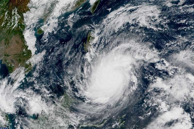
Odette was last spotted 175 kilometers east of Surigao City in Surigao del Norte with peak winds of 185 km per hour near the center and gusts of up to 230 kph, PAGASA said in its 11 a.m. bulletin.
The typhoon was heading west northwest at 25 kph.
According to the state weather bureau, the center of Odette’s eye is expected to make an initial landfall in the vicinity of Siargao-Bucas Grande Islands or Dinagat Islands between 1 p.m. and 3 p.m.
PAGASA hoisted wind signals over the following areas:
TCWS No. 4
(Very destructive typhoon-force winds prevailing or expected within 12 hours)
- Southern Leyte
- Eastern portion Bohol (Talibon, Trinidad, San Miguel, Dagohoy, Pilar, Sierra Bullones, Jagna, Garcia Hernandez, Duero, Guindulman, Anda, Candijay, Alicia, Mabini, Ubay, Pres. Carlos P. Garcia, Bien Unido)
- Dinagat Islands
- Surigao del Norte including Siargao and Bucas Grande Islands
"Winds may reach typhoon strength up to 185 km/h in strength within any of the areas where TCWS #4 is hoisted during the passage of the typhoon," PAGASA said.
TCWS No. 3
(Destructive typhoon-force winds prevailing or expected within 18 hours)
- Southern portion of Leyte (Abuyog, Mahaplag, Hilongos, Bato, Matalom, Hindang, Inopacan, City of Baybay, Javier, Macarthur)
- Southern and central portions of Cebu (Camotes Islands, Tuburan, Catmon, Carmen, Danao City, Asturias, Balamban, Cebu City, Compostela, Liloan, Consolacion, Lapu-Lapu City, Mandaue City, Toledo City, City of Talisay, Minglanilla, Samboan, Sibonga, Alcoy, Ginatilan, Boljoon, City of Carcar, Malabuyoc, Moalboal, Cordova, Oslob, Aloguinsan, Pinamungahan, Barili, Santander, Badian, Dalaguete, Alcantara, Ronda, Alegria, City of Naga, Argao, San Fernando, Dumanjug, Sogod)
- Rest of Bohol
- Negros Oriental
- Siquijor
- Southern and central portions of Negros Occidental (Calatrava, San Carlos City, Salvador Benedicto, City of Talisay, Silay City, Bacolod City, Murcia, Bago City, Valladolid, Pulupandan, La Carlota City, San Enrique, La Castellana, Moises Padilla, Pontevedra, Hinigaran, Isabela, Binalbagan, City of Himamaylan, City of Kabankalan, Ilog, Cauayan, Candoni, City of Sipalay, Hinoba-An)
- Guimaras
- Northern portion of Agusan del Norte (Kitcharao, Jabonga, Santiago, Tubay, City of Cabadbaran)
- Northern portion of Surigao del Sur (Carrascal, Cantilan, Madrid, Carmen, Lanuza, Cortes, City of Tandag)
TCWS No. 2
(Damaging gale- to storm-force winds prevailing or expected within 24 hours)
- Southern portion Albay (The city of Tabaco, Malilipot, Rapu-rapu, Bacacay, Santo Domingo, Legazpi City, Manito, Camalig, Daraga, Jovellar, Guinobatan, Pio Duran, City of Ligao, Oas)
- Sorsogon
- Masbate including Ticao and Burias Islands
- Romblon
- Central and southern portions of Oriental Mindoro (Pinamalayan, Gloria, Bansud, Bongabong, Roxas, Mansalay, Bulalacao, Socorro, Pola)
- Central and southern portions of Occidental Mindoro (Sablayan, Calintaan, Rizal, San Jose, Magsaysay)
- Palawan (El Nido, Calamian Islands, Taytay, Dumaran, Araceli, Cuyo Islands)
- Northern Samar
- Eastern Samar
- Samar
- Biliran
- Rest of Leyte
- Rest of Cebu
- Rest of Negros Occidental
- Iloilo
- Capiz
- Aklan
- Antique
- Rest of Surigao del Sur
- Agusan del Sur
- Rest of Agusan del Norte
- Extreme northern portion of Zamboanga del Norte (Dapitan City, Siayan, Sindangan, Jose Dalman, Manukan, Pres. Manuel A. Roxas, Katipunan, Sergio Osmeña Sr., Polanco, Dipolog City, Piñan, Mutia, La Libertad, Rizal, Sibutad)
- Extreme northern portion of Zamboanga del Sur (Josefina, Molave, Mahayag, Dumingag, Tambulig)
- Misamis Occidental
- Northern portion of Lanao del Norte (Kolambugan, Maigo, Munai, Bacolod, Poona Piagapo, Kauswagan, Pantao Ragat, Matungao, Linamon, Baloi, Tagoloan, Pantar, Iligan City)
- Misamis Oriental
- Camiguin
- Northern portion of Bukidnon (Cabanglasan, City of Malaybalay, Lantapan, Talakag, Baungon, Libona, Manolo Fortich, Sumilao, Impasug-Ong, Malitbog)
- Northern portion of Lanao del Sur (Tagoloan II, Kapai)
TCWS No. 1
(Strong winds prevailing or expected within 36 hours)
- Catanduanes,
- Camarines Norte
- Camarines Sur
- Rest of Albay
- Marinduque
- Southern portion of Quezon (San Antonio, Tiaong, Candelaria, Sariaya, Dolores, Lucena City, Pagbilao, Padre Burgos, Atimonan, Agdangan, Unisan, Gumaca, Plaridel, Pitogo, Lopez, Guinayangan, Buenavista, Catanauan, General Luna, Macalelon, Mulanay, San Narciso, San Andres, San Francisco, Tagkawayan, Calauag, Quezon, Alabat, City of Tayabas, Perez)
- Batangas
- Rst of Oriental Mindoro
- Rest of Occidental Mindoro
- Rest of mainland Palawan including Balabac and Kalayaan Islands
- Northern portion of Davao Oriental (Baganga, Cateel, Boston)
- Northern portion of Davao de Oro (Laak, Mawab, Nabunturan, Montevista, Monkayo, New Bataan, Compostela)
- Northern portion of Davao del Norte (Talaingod, Santo Tomas, Kapalong, Asuncion, San Isidro, New Corella)
- Rest of Bukidnon
- Rest of Lanao del Norte
- Rest of Lanao del Sur
- Rest of northern portion of Zamboanga del Norte (Labason, Kalawit, Tampilisan, Liloy, Salug, Godod, Bacungan, Gutalac, Baliguian)
- Rest of northern portion of Zamboanga del Sur (Bayog, Lakewood, Kumalarang, Guipos, Dumalinao, Tukuran, Ramon Magsaysay, Aurora, Sominot, Tigbao, Labangan, Pagadian City, Midsalip
- Northern portion of Zamboanga Sibugay (Titay, Ipil, Naga, Kabasalan, Siay, Diplahan, Buug)
What to expect
Heavy rains
- Caraga
- Central Visayas
- Misamis Oriental
- Camiguin
- Southern Leyte
- Negros Occidental
Moderate to heavy with at times intense rains
- Leyte
- Southern portions of Eastern Samar and Samar
- Zamboanga del Norte
- Lanao del Sur
- Davao Oriental
- Davao de Oro
- Davao del Norte
- Rest of Northern Mindanao
Light to moderate with at times heavy rains
- Bicol region
- Quezon
- Rest of Visayas
- Rest of Zamboanga Peninsula
- Mainland Bangsamoro.
According to PAGASA, there is a "moderate to high risk of storm surge of up to 3 meters in height which may cause life-threatening flooding in the low-lying coastal areas of the following areas:
- Central Visayas
- Northern Mindanao
- Iloilo
- Guimaras
- Negros Occidental
- Eastern Samar
- Southern Leyte
- Dinagat Islands
- Surigao del Norte
- Surigao del Sur
- Agusan del Norte
- Several localities in the northern portion of Palawan including Calamian, Cuyo and Cagayancillo Islands
- Antique
- Southern portion of Samar
- Leyte
- Davao Oriental
Odette is forecast to continue intensifying until it makes landfall this afternoon. It may reach a pre-landfall peak intensity of 185 to 195 kph.
It may slightly weaken once it crosses northeastern Mindanao, Visayas and Palawan, but it is forecast to remain a typhoon.
Over 45,000 people have sought shelter in emergency centers, according to the National Disaster Risk Reduction Center.
Track
- Thursday evening: Over the coastal waters of Ubay, Bohol
- Friday morning: Over the coastal waters of Cuyo Palawan
- Saturday morning: 200 km east of Pag-asa Island, Kalayaan, Palawan
- Sunday morning: 355 km northwest of Pag-asa Island, Kalayaan, Palawan (outside PAR)
- Monday morning: 1,020 km west of Northern Luzon (outside PAR)
- Tuesday morning: 975 km west of extreme Northern Luzon (outside PAR)


- Latest
- Trending