Tropical Depression Ofel maintains strength, moves west-northwestward
MANILA, Philippines — Tropical Depression Ofel is maintaining its strength as it moves toward Burias island in Masbate province, weather forecasters said Wednesday.
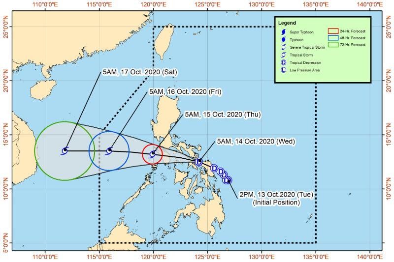
In its 11 a.m. bulletin Wednesday morning, state weather bureau Pagasa added that the tropical depression, which carries with it maximum sustained winds of 45 kilometers per hour near the center and gustiness of up to 55 kph, may pass close or over Romblon and Mindoro provinces.
READ: ‘Ofel’ makes second landfall in Sorsogon; Signal No. 1 up in 8 areas
Its center was last seen 50 km west of Juban, Sorsogon as of 10 a.m. Wednesday, moving west-northwestward at 10 kph.
"It is likely to emerge over the West Philippine Sea on tomorrow morning and exit the Philippine Area of Responsibility (PAR) on Friday morning or afternoon," Pagasa said.
"'Ofel' is forecast to remain a tropical depression while crossing the southern Luzon area. However, this weather disturbance is forecast to intensify into a tropical storm after emerging over the West Philippine Sea," it added.
State weather forecasters have also warned that flooding, including flash floods, and rain-induced landslides may occur during heavy or prolonged rainfall particularly in areas susceptible to these hazards.
Tropical Cyclone Wind Signal No. 1 remains hoisted over the following areas, where intermittent rains and winds of 30 to 60 kph may be expected in at least 36 hours:
- Batangas
- southern portion of Laguna, including Luisiana, Majayjay, Liliw, Nagcarlan, Rizal, San Pablo City, Calauan, Alaminos, Los Baños, Bay, Magdalena
- central and southern portions of Quezon including Guinayangan, Tagkawayan, Buenavista, San Narciso, San Andres, Mulanay, San Francisco, Catanauan, Lopez, Calauag, Quezon, Alabat, Perez, Atimonan, Tayabas City, Mauban, Sampaloc, Lucban, Gumaca, General Luna, Macalelon, Pitogo, Unisan, Plaridel, Padre Burgos, Agdangan, Pagbilao, Lucena City, Sariaya, Candelaria, Dolores, Tiaong, San Antonio
- Calamian Islands, Occidental Mindoro, Oriental Mindoro, Marinduque, Romblon, Camarines Norte, Camarines Sur, Catanduanes, Albay, Sorsogon and Masbate (including Ticao and Burias Islands)
Northern Samar, Eastern Samar, Samar and Biliran are no longer on TCWS 1.
"Ofel" is also set to bring moderate to heavy with at times intense rains over Bicol Region, Calabarzon, Aurora, Marinduque, Romblon, and Mindoro provinces, and light to moderate with at times heavy rains will be experienced over Metro Manila, Cagayan Valley, Cordillera Administrative Region, rest of Central Luzon.
Meanwhile, the southwest monsoon or habagat will bring moderate to heavy rains over Caraga, Davao Region, and Sarangani, and light to moderate with at times heavy rains may prevail over the rest of Mindanao.
Forecast positions
- Thursday morning: 265 km West of Calapan City, Oriental Mindoro(13.4 °N, 118.7 °E)
- Friday morning: 725 km West of Southern Luzon (Outside Philippine area of responsibility)( 13.8 °N, 114.5 °E)
- Saturday morning: 1,285 km West of Southern Luzon (Outside Philippine area of responsibility) ( 13.8 °N, 109.3 °E)
— Franco Luna


- Latest
- Trending