Only 3 areas under Signal No. 3 as ‘Tisoy’ weakens further
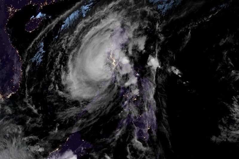
MANILA, Philippines — Weather forecasters have lifted storm signals in several areas as Typhoon Tisoy (Kammuri) continues to weaken and spirals away from land after it battered parts of Luzon and Visayas with torrential rains and destructive winds.
At 4 p.m., the typhoon was spotted 110 km northwest of San Jose, Occidental Mindoro or 135 km north of Coron, Palawan.
The weakening of “Tisoy” was expected after it made four landfalls over Sorsogon, Masbate, Marinduque and Oriental Mindoro. It now has peak winds of 130 kph from the previous 140 kph and gusts of up to 200 kph from the previous 205 kph.
The typhoon is heading west at 25 kph.
“Tisoy” lashed southern Luzon and parts of Visayas with fierce winds and heavy rains, toppling trees and power poles and forcing the evacuation of hundreds of thousands from their homes.
The typhoon also prompted suspensions of classes and work and cancellation
Residents of Quezon province and Rizal will experience frequent to continuous heavy (isolated intense rains) until Wednesday morning.
Occasional to frequent heavy rains are expected over Mindoro provinces, Metro Manila, Central Luzon, rest of CALABARZON, Cagayan Valley, Cordillera Administrative Region, Marinduque and Romblon and intermittent heavy rains over Calamian Islands.
PAGASA lifted storm signals over Masbate, Benguet, La Union, Albay, Sorsogon, Catanduanes, Capiz, Iloilo, southern Isabela and parts of Quirino, Nueva Vizcaya, Aklan, Samar, Northern Samar and Antique.
Tropical Cyclone Warning Signals, however, remain hoisted over the following areas:
TCWS No. 3 (Winds between 121 kph and 170 kph in at least 18 hours)
- Oriental Mindoro
- Occidental Mindoro, including Lubang Island
- Batangas
TCWS No. 2 (Winds between 61 kph and 121 kph in at least 24 hours)
- Romblon
- Camarines Norte
- Metro Manila
- Bulacan
- Bataan
- Tarlac
- Pampanga
- Rizal
- Quezon, including Polillo Islands
- Zambales
- Marinduque
- Cavite
- Laguna
- Northern portion of Camarines Sur (Cabugao, Libmanan, Pamplona, Pasacao, Sipocot, Lupi, Ragay, Del Gallego)
- Southern portion of Nueva Ecija (Cabanatuan City, Cabiao, Gabaldon, Gapan City, General Tinio, Jaen, Laur, Palayan City, Peñaranda, San Antonio, San Isidro, San Leonardo, Santa Rosa, Aliaga, Licab and Zaragoza)
- Southern Aurora (Dipaculao, Maria Aurora, Baler, San Luis, Dingalan)
- Calamian Islands (Coron, Busuanga, Culion, Linapacan)
TCWS No. 1 (Winds between 30 kph and 60 kph)
- Southern portion of Quirino (Nagtipunan)
- Rest of Aurora
- Northern portion of Palawan (El Nido, Taytay, Araceli, Dumaran)
- Rest of Camarines Sur
- Cuyo Islands (Cuyo, Magsaysay, Agutaya)
- Pangasinan
- Southern portion of Nueva Vizcaya (Alfonso, Castaneda, Aritao, Dupax Del Norte, Dupax De Sur, Kasibu, Santa Fe)
- Burias Island
- Rest of Nueva Ecija
- Northern Aklan (Malay, Buruanga, Nabas, Ibajay)
- Northern Antique (Caluya, Libertad, Pandan)
Weather forecasters warned the possibility of storm surges of up to three meters over several coastal areas in Marinduque, Mindoro provinces, Romblon, Cavite and Batangas.
Forecast positions
- Wednesday afternoon: 375 km west of Subic, Zambales
- Thursday afternoon: 655 km west of Subic, Zambales (outside PAR)
- Friday afternoon: 775 km west of Coron, Palawan (outside PAR)
— Gaea Katreena Cabico


- Latest
- Trending