Signal No. 1 still up in Batanes, Babuyan Islands as 'Egay' maintains strength
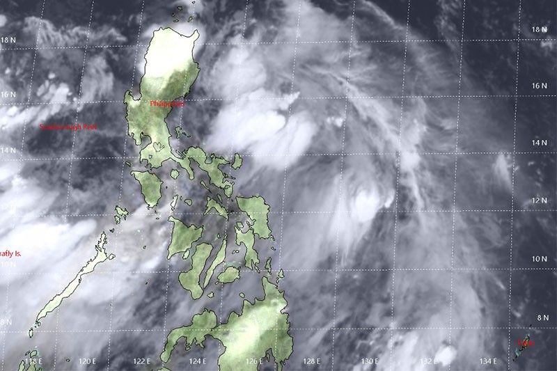
MANILA, Philippines — Signal No. 1 is still hoisted in Batanes and Babuyan Group of Islands as Tropical Depression Egay maintains its strength.
According to state weather bureau PAGASA, the weather disturbance is now moving toward extreme northern Luzon.
PAGASA warned fisherfolks and those with small seacraft in areas under Signal No. 1 not to venture out due to moderate to rough seas brought about by the tropical depression.
At 7 a.m., the center of Egay was located 165 kilometers east of Aparri, Cagayan.
The tropical depression packs maximum winds of 45 kph with gusts of up to 60 kph. It is forecast to move northwest at 35 kph.
It is forecasted to be at 280 kilometers west-northwest of Basco, Batanes by Tuesday evening, which is outside the Philippine area of responsibility.
Meanwhile, the "habagat" or southwest monsoon will continue to bring rains over Metro Manila, Ilocos, Cordillera Administrative Region, Central Luzon, Calabarzon, Mimaropa, Bicol, Antique, Aklan and western Iloilo.
The rest of Luzon and Western Visayas are expected to experience cloudy skies with scattered rainshowers and thunderstorms.
"Residents in the aforementioned areas, especially those living in areas identified to be at high risk of flooding and landslides, are advised to take precautionary measure, coordinate with local disaster risk reduction and management offices, and continue monitoring for updates, especially the Thunderstorm Advisories and Heavy Rainfall Warnings to be issued by PAGASA Regional Services Divisions," PAGASA said. — Patricia Lourdes Viray
PAGASA has raised Tropical Cyclone Wind Signal No. 1 over Batanes, where it says winds of 30-60 kph can be expected in the next 36 hours due to Tropical Depression Egay.
PAGASA also says intermittent rains may be expected within 36 hours.
Tropical Cyclone Warning Signal No. 1 is also up over the province.
The low pressure area, now Tropical Depression "Egay, packs maximum sustained winds of 55 kilometer per hour near the center and gustiness of up to 70kph and central pressure 1004 hPa.
It is slowly moving north northwestward.
PAGASA says the tropical depression's center was estimated based on all available data at 900 km East of Southeastern Luzon (14.4°N, 132.5°E).
The LPA that used to be "Egay" has completely dissipated, PAGASA says.
But rains are still expected in Pangasinan, Zambales, Bataan, Mindoro and Palawan due to habagat.
Metro Manila will also experience cloudy skies with scattered rainshowers.
Tropical Depression Egay remains almost stationary, PAGASA says in its 11 a.m. severe weather bulletin.
PAGASA says monsoon rains may continue on Tuesday, July 2, over Metro Manila, Ilocos, Cordillera, Zambales, Bataan, Tarlac, Pampanga, Bulacan, Mindoro Provinces and Palawan.
"Egay" is expected to weaken into a low pressure area within 12 to 24 hours.
Its center was located at 195 km east-northeast of Aparri, Cagayan or 205 km east of Calayan, Cagayan at 10 a.m. today.
It packs maximum winds of up to 45 kph near the center and gustiness of up to 60 kph.
Signal No. 1 is still hoisted over Batanes and Babuyan Group of Islands.
Tropical Depression Egay maintains strength as it moves toward extreme northern Luzon.
At 7 a.m., the center of "Egay" was estimated based on all available data at 165 km east of Aparri, Cagayan.
It packs maximum winds of up to 45 kph near the center and gustiness of up to 60 kph. It moves northwest at 35 kph.
Signal No. 1 is still up over Batanes and Babuyan Group of Islands.
Tropical Depression Egay slightly weakens as it barrels northwestward at 40 kph, PAGASA says.
The state weather bureau adds that the southwest monsoon will bring light to moderate with at times heavy monsoon rains over Metro Manila, Ilocos Region, Cordillera Administrative Region, Central Luzon, Calabarzon, Mimaropa, Bicol, Antique, Aklan and western Iloilo.
Cloudy skies with scattered rain showers and thunderstorms, on the other hand, are expected over the rest of Luzon and Western Visayas.
At 4 a.m., the center of "Egay" was estimated based on all available data at 195 km east-northeast of Aparri, Cagayan or 205 km east of Calayan, Cagayan.
It packs maximum sustained winds of 45 kph near the center and gustiness of up to 60 kph.
Signal No. 1 is raised over Batanes and the Babuyan Group of Islands.


- Latest
- Trending