UP Resilience Institute completes Quezon City waterway mapping
MANILA, Philippines — The University of the Philippines Resilience Institute (UPRI) said it has completed the Quezon City waterway mapping, plotting 446 kilometers more of the city’s waterways.
The waterway mapping was a joint initiative of the UP Resilience Institute Youth Mappers, UPRI-Nationwide Operational Assessment of Hazards (NOAH) Center and the OpenStreetMap Philippines community.
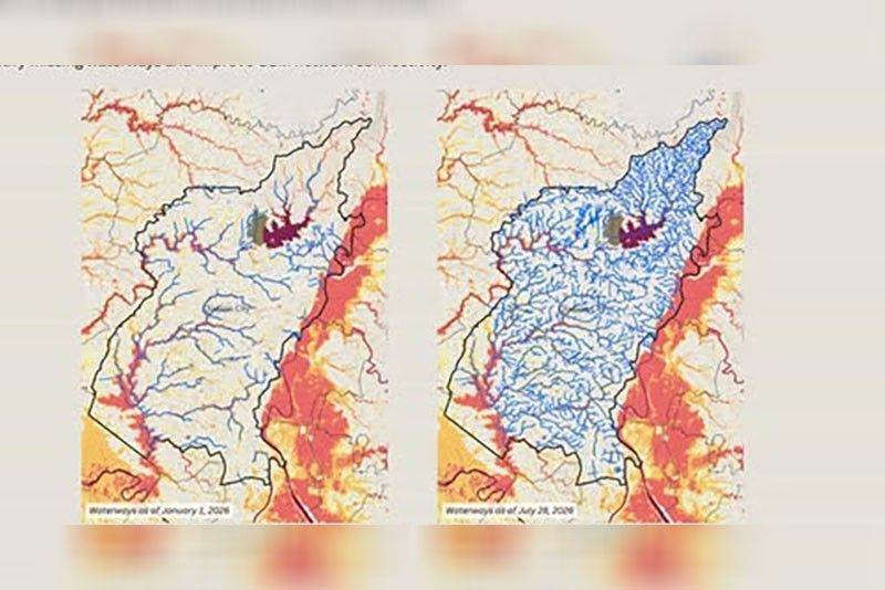
Conducted under #ChasingWaterways, a community mapping initiative, the groups identified and mapped missing and hidden waterways across Quezon City from January to July.
“In a highly urbanized city, waterways do not always look like waterways. Some channels are diverted, disappear beneath roads and buildings, or pass through culverts and drainage systems. Others may simply be missing from existing maps,” the UPRI said.
The mapping project addressed a persistent challenge in urban geospatial data, including small waterways, drainage channels, culverts and modified streams that can be difficult to identify from satellite imagery alone.
“Yet these features form part of the network through which water moves across the city, making their representation important for flood-related mapping and analysis. To help locate these features, #ChasingWaterways combined geospatial analysis with community and local mapping knowledge,” the UPRI said.
The initiative systematically identified potential gaps in OpenStreetMap and directed volunteer mappers to areas that needed closer investigation, using terrain-derived drainage networks and flood hazard data from the UPRI-NOAH Center.
“Waterways may be diverted or channelized, disappear beneath roads and buildings, or pass through culverts and engineered drainage systems. Because of this, drainage networks derived from elevation data do not always correspond with waterways observable on the ground or represented in existing maps,” the UPRI said.
According to the UPRI, 32 contributors had completed more than 1,000 mapping tasks in July and added 446 kilometers of waterways to OpenStreetMap. The mapped waterway network increased from 185 kilometers in January to 631 kilometers by July.
“These figures represent a substantial expansion of the waterway network represented in OpenStreetMap within Quezon City. More importantly, the initiative helped build a more connected representation of the city’s waterways,” the UPRI said.



- Latest
- Trending