Signal No. 2 up in Aurora, parts of CALABARZON as ‘Aghon’ keeps strength
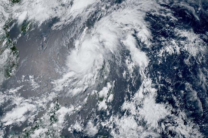
MANILA, Philippines — The province of Aurora was placed under Tropical Cyclone Wind Signal (TCWS) No. 2 as Tropical Storm Aghon (international name: Ewiniar) maintained its strength over Quezon province, PAGASA said on Sunday afternoon.
Aghon, the country’s first cyclone this year, was last spotted in the vicinity of Mauban town with peak winds of 75 kilometers per hour near the center and gusts of up to 125 kph.
It was heading northwestward, across mainland Quezon province and Polillo Islands, slowly.
PAGASA raised wind signals over the following areas:
Signal No. 2 (Winds between 62 kph and 88 kph may be expected in at least 24 hours)
- Aurora
- Northern and central portions of Quezon (Alabat, Perez, Quezon, Gumaca, Lopez, Macalelon, General Luna, Unisan, Pitogo, Plaridel, Agdangan, Padre Burgos, Atimonan, Mauban, Real, General Nakar, Infanta, Sampaloc, Pagbilao, Calauag, Lucban, City of Tayabas, Lucena City, Tiaong, Candelaria, Sariaya, Dolores, San Antonio) including Polillo Islands
- Laguna
- Eastern portion of Batangas (City of Tanauan, San Jose, Lipa City, Mataasnakahoy, Balete, Malvar, Santo Tomas, Cuenca, San Pascual, Batangas City, Ibaan, Padre Garcia, Rosario, San Juan, Taysan, Lobo)
- Eastern portion of Rizal (Jala-Jala, Pililla, Tanay, Cardona, Binangonan, Morong, Baras)
Residents of areas under Signal No. 2 could experience minor to moderate impacts from strong winds.
Signal No. 1 (Winds between 39 and 61 kph may be expected in at least 36 hours or intermittent rains may be expected within 36 hours)
- Eastern portion of Isabela (Divilacan, San Mariano, San Guillermo, Jones, Echague, San Agustin, Ilagan City, Benito Soliven, City of Cauayan, Maconacon, Angadanan, Naguilian, Palanan, Dinapigue)
- Eastern portion of Quirino (Maddela, Nagtipunan, Aglipay)
- Southern portion of Nueva Vizcaya (Alfonso Castaneda, Dupax del Sur, Dupax del Norte)
- Eastern and southern portions of Nueva Ecija (General Tinio, Gabaldon, Bongabon, Pantabangan, Rizal, General Mamerto Natividad, Laur, Palayan City, Peñaranda, San Leonardo, City of Gapan, Cabanatuan City, Santa Rosa, San Isidro, Cabiao, San Antonio, Jaen, Zaragoza, Aliaga, Talavera, Llanera)
- Southern portion of Bataan (Orani, Samal, City of Balanga, Abucay, Pilar, Orion, Limay, Mariveles, Bagac)
- Eastern portion of Pampanga (Candaba, San Luis, San Simon, Apalit, Santa Ana, Arayat, Mexico, Santa Rita, Guagua, Sasmuan, Macabebe, Masantol, Santo Tomas, Minalin, City of San Fernando, Bacolor, Lubao)
- Bulacan
- Metro Manila
- Rest of Quezon
- Rest of Rizal
- Cavite
Rest of Batangas - Northern and central portions of Oriental Mindoro (Pinamalayan, Pola, Naujan, Victoria, Socorro, City of Calapan, Bansud, Gloria, Baco, San Teodoro, Puerto Galera, Bongabong)
- Marinduque
- Extreme northern portion of Romblon (Concepcion, Corcuera, Banton)
- Camarines Norte
- Camarines Sur
Residents of areas under Signal No. 1 could experience minimal to minor impacts from strong winds.
What to expect
PAGASA said that Aghon could bring rain of up to 200 millimeters over Quezon province, and between 100 and 200 mm over Aurora, eastern portion of Bulacan, Rizal, Laguna, Metro Manila and Camarines Norte until Monday afternoon.
Meanwhile, the eastern portion of Isabela, Nueva Ecija, the rest of Bulacan, the eastern portion of Pampanga, Cavite, Batangas, Oriental Mindoro, Occidental Mindoro, Romblon, Burias Island, the western portion of Camarines Sur, Cuyo Islands, Aklan, and Antique will have 50 to 100 mm of rainfall.
The state weather bureau warned of higher rainfall in elevated or mountainous areas. This can lead to flooding and landslides, especially in areas susceptible to these hazards or places that have experienced recent heavy rain.
PAGASA also said that there is a minimal to moderate risk of storm surge over the exposed and low-lying coastal areas of Cagayan, Isabela, Aurora, Central Luzon, Metro Manila, CALABARZON, Mindoro provinces, Marinduque, Romblon, Camarines Norte, Camarines Sur, and Burias Island within the next 24 hours.
Sea travel is risky for small seacrafts, including all motor bancas, over the coastal waters of Aurora, Marinduque and Quezon province, southern coastal waters of Batangas and northern coastal waters of Camarines Norte.
Aghon will also bring moderate to rough seas of 1.5 to 3.5 meters over the coastal waters along the northern and eastern seaboards of Luzon and the seaboard of Bicol region.
According to the National Disaster Risk Reduction and Management Council (NDRRMC), four individuals in Bicol region were reportedly injured, and over 2,700 people were affected by Aghon.
Aghon's track
After crossing mainland CALABARZON and Polillo Islands, the tropical storm is expected to be over the waters off the east coast of Quezon province this evening.
During this time, Aghon will likely remain a tropical storm, although it could intensify into a severe tropical storm while over the sea east of Quezon province.
Starting Monday, Aghon will gradually accelerate northeastward while intensifying. It may reach typhoon category by Tuesday afternoon or evening, and may exit the Philippine Area of Responsibility (PAR) on Wednesday.
Forecast position
- May 26, 2024 11:00 p.m. - 80 km east northeast of Infanta, Quezon
- May 27, 2024 11:00 a.m. - 140 km east of Casiguran, Aurora
- May 27, 2024 11:00 p.m. - 280 km east of Tuguegarao City, Cagayan
- May 28, 2024 11:00 a.m. - 520 km east of Calayan, Cagayan
- May 28, 2024 11:00 p.m. - 695 km east northeast of Basco, Batanes
- May 29, 2024 11:00 a.m. - 1,050 km east northeast of extreme Northern Luzon
- May 30, 2024 11:00 a.m. - 1,625 km east northeast of extreme Northern Luzon (outside PAR)
— Gaea Katreena Cabico


- Latest
- Trending