Six areas in Mindanao under Signal No. 2 ahead of Kabayan's landfall
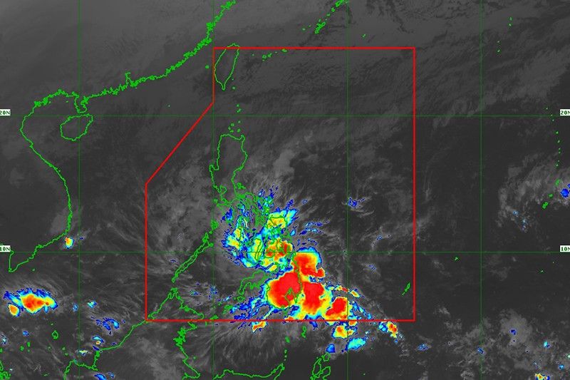
MANILA, Philippines — State weather bureau PAGASA placed several areas in Mindanao under Wind Signal No. 2 Monday morning as Tropical Storm Kabayan (international name: Jelawat) approached the Philippine landmass.
Kabayan, the country's 11th cyclone this year, was last spotted over the coastal waters of Manay in Davao Oriental. Moving west at 20 kilometers per hour, it is expected to make landfall in the province this morning.
The tropical storm is packing peak winds of 65 kph near the center and gusts of up to 80 kph.
PAGASA hoisted wind signals in the following areas:
Signal No. 2
- Dinagat Islands
- Surigao del Norte including Siargao and Bucas Grande Islands
- Surigao del Sur
- Northern portion of Agusan del Norte (Kitcharao, Jabonga, Santiago, City of Cabadbaran, Remedios T. Romualdez, Tubay)
- Eastern portion of Agusan del Sur (Trento, Bunawan, San Francisco, Rosario, Prosperidad, City of Bayugan, Sibagat)
- Northern portion of Davao Oriental (Boston, Cateel)
Residents of areas under Signal No. 2 may experience minor to moderate impacts from gale force winds.
Signal No. 1
- Southern portion of mainland Palawan (Sofronio Española, Brooke's Point, Bataraza, Balabac, Rizal, Quezon, Narra)
- Cagayancillo Islands
- Southern Leyte
- Leyte
- Southern portion of Samar (Basey, Santa Rita, Marabut, Talalora, Villareal, Pinabacdao)
- Southern portion of Eastern Samar (Maydolong, City of Borongan, Quinapondan, Guiuan, Lawaan, Balangiga, Llorente, Giporlos, Salcedo, Balangkayan, General Macarthur, Hernani, Mercedes)
- Cebu including Camotes and Bantayan Islands
- Bohol
- Siquijor
- Negros Oriental
- Negros Occidental
- Guimaras
- Rest of Agusan del Norte
- Rest of Agusan del Sur
- Central portion of Davao Oriental (Baganga, Manay, Caraga, Tarragona, Lupon, Banaybanay)
- Davao de Oro
- Davao del Norte
- Davao City
- Camiguin
- Misamis Oriental
- Bukidnon
- Misamis Occidental
- Lanao del Norte
- Lanao del Sur
- Northern portion of Maguindanao del Norte (Buldon, Barira, Matanog, Parang, Sultan Kudarat, Sultan Mastura)
- Northern portion of Cotabato (Arakan, Carmen, Banisilan, Alamada, President Roxas, Kabacan, Matalam, Antipas, Magpet, Libungan, Pigkawayan)
- Northern and central portions of Zamboanga del Norte (Siayan, Sindangan, Jose Dalman, Manukan, Pres. Manuel A. Roxas, Sergio Osmeña Sr., Katipunan, Dipolog City, Polanco, Mutia, Piñan, Dapitan City, Sibutad, La Libertad, Rizal, Siocon, Baliguian, Gutalac, Labason, Kalawit, Tampilisan, Liloy, Salug, Godod, Bacungan)
- Zamboanga del Sur
- Zamboanga Sibugay
Minimal to minor impacts from strong winds are possible within any of these areas.
Heavy rainfall
According to PAGASA, Surigao del Sur, Surigao del Norte, Dinagat Islands, Agusan del Sur, Davao del Norte, Davao de Oro and Davao Oriental are expected to receive an accumulated rainfall of 100 to 200 millimeters today.
Meanwhile, Central Visayas, Biliran, Leyte, Southern Leyte, Zamboanga del Norte, Northern Mindanao, Davao City, Cotabato, Lanao del Sur, the southern portions of Samar and Eastern Samar, and the rest of Caraga, Davao Oriental, Davao de Oro, and Davao del Norte will have an accumulated rainfall ranging between 50 and 100 millimeters.
The weather bureau warned that rainfall is expected to be higher in mountainous areas. This may result in flooding and landslides, particularly in areas highly susceptible to these hazards and those that have experienced significant rainfall in recent days.
The shear line, a weather system formed when cold and warm winds converge, may also bring heavy rain to the eastern portion of southern Luzon.
PAGASA said that once Kabayan makes landfall in Davao Oriental, it is forecast to cross Mindanao's rugged terrain and emerge over Sulu Sea this afternoon or evening.
Kabayan is expected to be downgraded into a tropical depression after landfall.
It is also not ruling out the possibility of the cyclone being further downgraded into a low pressure area while over land or after emerging over the sea. In such a case, however, redevelopment into a cyclone may still occur over the Sulu Sea.
Then, Kabayan will traverse the Sulu Sea, south of Cagayancillo Islands. It is forecast to make another landfall, this time as a tropical depression, over central or southern Palawan Tuesday morning or afternoon.
Kabayan will emerge over the West Philippine Sea shortly thereafter. It may come close or pass over the Kalayaan Islands between Tuesday evening and Wednesday morning.
Forecast position
- Dec. 18, 2023 5 p.m. - In the vicinity of Midsalip, Zamboanga del Sur
- Dec. 19, 2023 5 a.m. - 370 km west of Dipolog City, Zamboanga del Norte
- Dec. 19, 2023 5 p.m. - Over the coastal waters of Rizal, Palawan
- Dec. 20, 2023 5 a.m. - 205 km south southeast of Pag-asa Island, Kalayaan, Palawan or 425 km west of Puerto Princesa City, Palawan (outside PAR)
- Dec. 20, 2023 5 p.m. - 270 km southwest of Pag-asa Island, Kalayaan, Palawan or 680 km west of Puerto Princesa City, Palawan (outside PAR)
- Dec. 21, 2023 5 a.m.- 880 km west of southwestern Luzon (outside PAR)
- Dec. 22, 2023 5 a.m.- 1,555 km west of estern Mindanao (outside PAR)


- Latest
- Trending