More areas under Signal No. 2 as 'Karding' intensifies further
FOR THE LATEST 'KARDING' UPDATES, CHECK THESE LINKS:
- Signal No.5 over Polillo as ‘Karding’ seen to make landfall in northern Luzon
- LIVE updates: Super Typhoon Karding
--
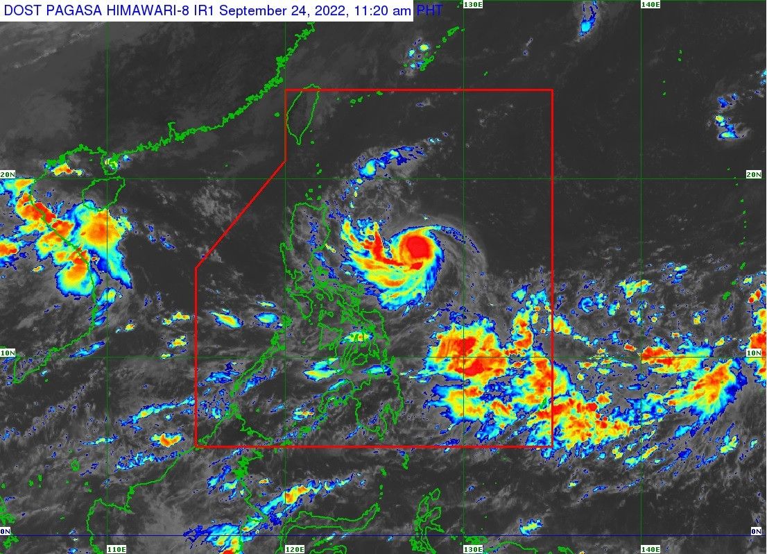
MANILA, Philippines (Update 2, 5:34 p.m.) — State weather service PAGASA has raised Signal No. 2 over more areas as Severe Tropical Storm Karding (international name: Noru) further intensified, packing winds of 110 kph near the center and gusts of up to 135 kph.
The following areas under Signal No. 2 can expect winds between 61 kph and 120 kph in at least 24 hours:
- Southeastern portion of Isabela (Dinapigue, Jones, San Agustin, Echague, San Guillermo, San Mariano)
- Southeastern portion of Quirino (Nagtipunan, Maddela)
- Southeastern portion of Nueva Vizcaya (Alfonso Castaneda)
- Eastern portion of Nueva Ecija (Bongabon, Laur, Palayan City, General Tinio, Gabaldon, Pantabangan, Rizal)
- Aurora
- Eastern portion of Bulacan (Doña Remedios Trinidad, Norzagaray)
- Eastern portion of Rizal (Rodriguez, City of Antipolo, Tanay)
- Eastern portion of Laguna (Santa Maria, Famy, Siniloan, Pangil, Pakil, Paete, Kalayaan, Lumban, Cavinti)
- Northern and central portion of Quezon (General Nakar, Pollilo Islands, Infanta, Real, Mauban, Perez, Alabat, Quezon, Calauag, Tagkawayan, Guinayangan)
- Northwestern portion of Camarines Sur (Del Gallego, Ragay, Lupi, Sipocot)
- Camarines Norte
Meanwhile, Signal No. 1 is up over the following areas:
- Metro Manila
- Southern portion of Cagayan (Peñablanca, Iguig, Tuguegarao City, Enrile, Solana, Tuao, Piat, Amulung, Rizal)
- Rest of Isabela
- Rest of Quirino
- Rest of Nueva Vizcaya
- Southern portion of Apayao (Conner)
- Abra
- Kalinga
- Mountain Province
- Ifugao
- Benguet
- Southern portion of Ilocos Norte (Nueva Era, Badoc, Pinili, Banna, City of Batac, Currimao, Paoay, Marcos)
- Ilocos Sur
- La Union
- Pangasinan
- Rest of Nueva Ecija
- Rest of Bulacan
- Tarlac
- Pampanga
- Zambales
- Bataan
- Rest of Laguna
- Rest of Rizal
- Rest of Quezon
- Cavite
- Batangas
- Rest of Camarines Sur
- Albay
- Catandauanes
- Marinduque
- Northwestern portion of Occidental Mindoro (Lubang Islands, Paluan, Abra de Ilog)
- Northewestern portion of Oriental Mindoro (San Teodoro, Puerto Galera, City of Calapan, Baco)
Areas under Signal No. 1 can expect winds between 30 kph to 60 kph in at least 36 hours.
PAGASA said that the highest wind signal that it would likely raise is Signal No. 4.
Karding is likely to make landfall Sunday morning or afternoon as a typhoon over the east coast of Aurora or the northern portion of Quezon, according to PAGASA.
From Saturday night to early Sunday morning, light to moderate with at times heavy rains are expected over Batanes, Cagayan, Isabela, the northern portion of Aurora, Catanduanes, Camarines Norte and Camarines Sur.
From the rest of Sunday until early Monday morning, Aurora, Nueva Ecija, Tarlac, Pangasinan, and the northern portion of Zambales are expected to experience heavy to intense with at times torrential rains.
During that same period, Central Luzon will experience moderate to heavy with at times intense rains, while Cagayan, Isabela, Quirino, Nueva Vizcaya, Cordillera Administrative Region, Ilocos Provinces, La Union, Metro Manila and Calabarzon will experience moderate to heavy rains.
“Under these conditions, scattered flooding and rain-induced landslides are possible, especially in areas that are highly or very highly susceptible to these hazards,” PAGASA warned.
Occasional rains may also occur over most of Southern Luzon and Visayas, especially over their western sections, starting Saturday or Sunday due to the southwest monsoon or habagat influenced by Karding.
A gale warning is up over the eastern seaboards of Luzon due to Karding, while PAGASA warns small seacrafts that sailing may be risky in the northern and western seaboards of Northern Luzon due to the northeasterlies and the cyclone.
Forecast position
- September 25, 2 a.m. - 300 km East of Baler, Aurora
- September 25, 2 p.m. - 95 km East Southeast of Baler, Aurora
- September 26, 2 a.m. - in the vicinity of Santa Cruz, Zambales
- September 26, 2 p.m. - 360 km West of Dagupan City, Pangasinan
- September 27, 2 a.m. - 630 km West of Dagupan City, Pangasinan (outside PAR)
- September 27, 2 p.m. - 875 km West of Central Luzon (outside PAR)
— Xave Gregorio


- Latest
- Trending