Signal No. 1 stays in several areas in Luzon as 'Dodong' speeds up
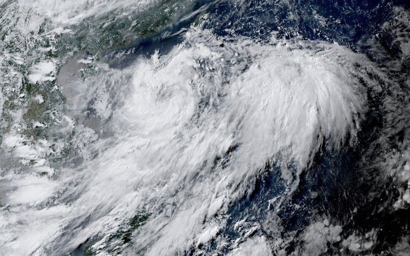
MANILA, Philippines — Tropical Depression Dodong has gained speed and continues to progress in a westward direction while moving over the coastal waters of Laoag, Ilocos Norte, state weather bureau PAGASA said.
Based on its 5 p.m. weather bulletin, Dodong's center was estimated to be over the coastal waters of Laoag, Ilocos Norte, with peak winds of 45 kilometers per hour near the center and gustiness of up to 75 kph.
The fourth tropical cyclone to enter the country this year, Dodong is moving at an accelerated speed of 20 kph in a westward direction.
Tropical Cyclone Wind Signal No. 1 is hoisted in the following areas in Luzon:
- Cagayan including Babuyan Islands
- Apayao
- Ilocos Norte
- Abra
- Ilocos Sur
- Mountain Province
- Kalinga
- northern portion of Isabela (Mallig, Quezon, Santa Maria, Cabagan, Delfin Albano, Tumauini, Santo Tomas, San Pablo, Maconacon)
Minimal to minor impacts from strong winds are anticipated in areas under TCWS No. 1.
What to expect
PAGASA said that Dodong is forecast to move westward or west-northwestward before turning generally northwestward over the West Philippine Sea until it exits the Philippine Area of Responsibility (PAR) Saturday evening or on Sunday early morning.
"Outside the PAR, Dodong will move generally west northwestward over the waters south of southern China," PAGASA said.
It will reach the tropical storm category by Saturday while over the West Philippine Sea.
Rainfall forecast
PAGASA predicted an accumulated rainfall of 50-100 millimeters from Friday to Saturday afternoon in the following areas:
- Cagayan
- Apayao
- Kalinga
- Abra
- Benguet
- Ilocos Norte
- La Union
- Pangasinan
"Under these conditions, flooding and rain-induced landslides are possible, especially in areas that are highly or very highly susceptible to these hazard as identified in hazard maps and in localities that experienced considerable amounts of rainfall for the past several days," the state weather bureau said.
The enhanced southwest monsoon may result in gusty conditions in several regions.
On Friday, MIMAROPA, Bicol Region, Western Visayas, CALABARZON, Metro Manila, Central Luzon and other areas of Northern Luzon should be prepared for potential gusty conditions caused by the enhanced southwest monsoon.
The same regions will continue to experience gusty conditions, along with Zambales, Bataan, Aurora, Pangasinan, La Union, Isabela and Benguet on Saturday.
PAGASA advised that residents in MIMAROPA, Bicol Region, Western Visayas, Cavite, Zambales, Bataan, Aurora, Pangasinan, La Union, Isabela, and Benguet should remain cautious as gusty conditions are expected to persist until Sunday.
In the next 24 hours, the state weather bureau said the eastern seaboards of northern Luzon may experience moderate to rough seas with wave heights ranging from 1.5 to 2.5 meters.
The western seaboards of northern Luzon, as well as the western seaboards of central and southern Luzon, should anticipate rough seas with wave heights between 2.0 to 3.5 meters.
"Mariners of small seacrafts are advised to take precautionary measures when venturing out to sea. If inexperienced or operating ill-equipped vessels, avoid navigating in these conditions," PAGASA said.
Forecast position
- July 15, 2023 (Saturday) 02:00 a.m. - 120 km west northwest of Laoag City, Ilocos Norte
- July 15, 2023 (Saturday) 02:00 p.m. - 205 km west northwest of Laoag City, Ilocos Norte
- July 16, 2023 (Sunday) 02:00 a.m. - 365 km west of Calayan, Cagayan (outside PAR)
- July 16, 2023 (Sunday) 02:00 p.m. - 595 km west of Basco, Batanes (outside PAR)
- July 17, 2023 (Monday) 02:00 a.m. - 730 km west of Basco, Batanes (outside PAR)
- July 17, 2023 (Monday) 02:00 p.m. - 820 km west of extreme northern Luzon (outside PAR)
- July 18, 2023 (Tuesday) 02:00 p.m. - 1,045 km west of extreme northern Luzon (outside PAR)
- July 19, 2023 (Wednesday) 02:00 p.m. - 1,420 km west of extreme northern Luzon (outside PAR)


- Latest
- Trending