'Karding' weakens slightly; Signal No. 1 still up in parts of Luzon
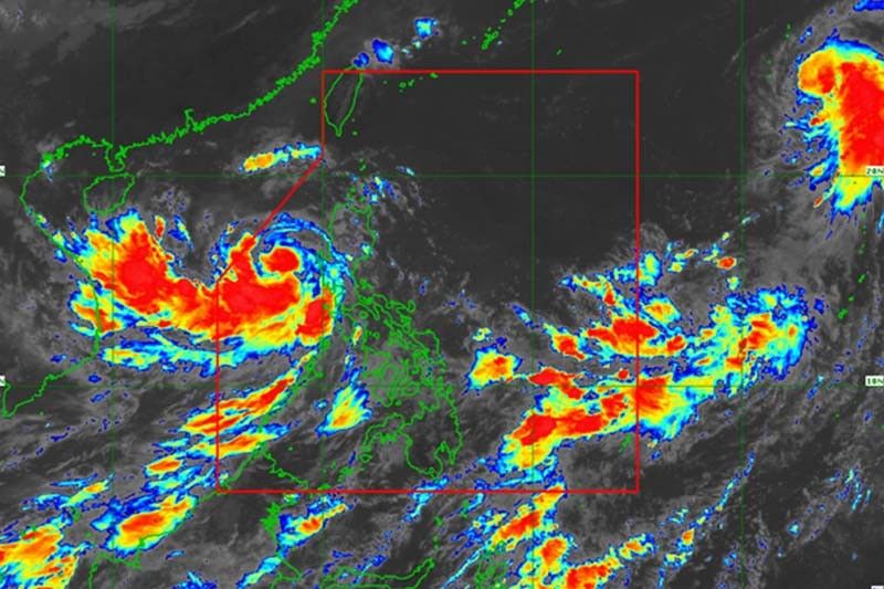
MANILA, Philippines — Typhoon Karding (Noru) has weakened slightly as it continued to move away from Luzon after battering the island with heavy rains and fierce winds, PAGASA said Monday.
Karding was last sighted 230 kilometers west of Dagupan City in Pangasinan, with peak winds of 130 kph and gusts of up to 160 kph.
Moving west northwest at 30 kph, the typhoon is expected to exit the Philippine Area of Responsibility Monday evening.
Wind Signal No. 1 remained hoisted over the following areas:
- Central and western portions of Pangasinan (Santa Barbara, Bayambang, Mangaldan, Dagupan City, Calasiao, San Carlos City, Basista, Urbiztondo, Mangatarem, Aguilar, Bugallon, Binmaley, Lingayen, Labrador, Sual, City of Alaminos, Bolinao, Anda, Bani, Agno, Burgos, Mabini, Dasol, Infanta, Malasiqui, Alcala, Bautista)
- Zambales
- Western portion of Tarlac (Camiling, San Clemente, Santa Ignacia, San Jose, Mayantoc, Capas, Bamban)
- Northwestern portion of Pampanga (Mabalacat City, Angeles City, Porac, Floridablanca)
What to expect
According to PAGASA, gale-force conditions remain possible within any of the areas where Wind Signal No. 1 is raised. Strong winds—or strong breeze to near gale strength—may be also experienced in areas under Signal No. 1.
Residents of Zambales, Bataan, Lubang Islands, and the west portion of Pangasinan will experience light to moderate with at times heavy rains until Monday afternoon.
Occasional to monsoon rains can also affect the western sections of Central Luzon, Southern Luzon, and Visayas.
PAGASA also warned that the enhanced southwest monsoon may bring moderate to rough seas (1.5 to 3 meters) over the western seaboards of Southern Luzon, Visayas, and Mindanao. These conditions may be risky for those using small seacrafts.
Karding, the strongest tropical cyclone to hit the Philippines this year, made landfalls in Quezon province and Aurora before battering the agricultural region of Central Luzon. It toppled trees and power lines, and flooded low-lying communities.
The Philippines, one of the most vulnerable countries to the effects of climate change, is hit by an average of 20 storms annually. Scientists warn that cyclones are becoming more intense as the world gets warmer because of human-induced climate change.
Karding ravaged the country after an unprecedented “explosive intensification,” PAGASA earlier said.
Karding’s track
- September 26, 8 PM: 475 west of Dagupan City, Pangasinan (outside PAR)
- September 27, 8 AM: 775 km west of Dagupan City, Pangasinan (outside PAR)


- Latest
- Trending