


Typhoon Basyang joins 'Agaton' inside PAR
MANILA, Philippines (Updated 3:26 p.m.) — Only eight areas in Visayas and Mindanao remained under Tropical Cyclone Wind Signal No. 1 as Tropical Depression Agaton continued to move slowly, forecasters said Tuesday afternoon.
In a bulletin issued past 2 p.m., PAGASA said the slow-moving cyclone was last seen in the vicinity of Llorente in Eastern Samar, with maximum sustained winds of 45 kilometers per hour near the center and gusts of up to 75 kph.
The following areas remained under Tropical Cyclone Wind Signal No. 1:
• Eastern Samar
• Samar
• Northern Samar
• Biliran
• Leyte
• Southern Leyte
• Camotes Island
• Dinagat Islands
Strong winds will be experienced in areas under TCWS No. 1. PAGASA, however, noted that Agaton's winds have “minimal to minor threat to life and property.”
In the next 24 hours, rough seas (2.8 to 4 meters) will prevail over the seaboards of areas under TCWS No. 1.
“These conditions may be risky for most seacrafts,” forecasters warned.
Moderate to heavy with at times intense rains will be experienced in the following areas:
• Eastern Visayas
• Bicol region
• Northern and central portions of Cebu including Bantayan and Camotes Islands
• Aklan
• Capiz
• Iloilo
• Antique
• Guimaras
• Northern and central portions of Negros provinces
Meanwhile, light to moderate with at times heavy rains will affect the following areas:
• MIMAROPA
• Dinagat Islands
• Zamboanga del Norte
• Quezon province
• Rest of Visayas
According to PAGASA, Agaton is expected to move slowly within the next six to 12 hours toward the Philippine Sea beginning Tuesday evening or Wednesday morning.
The tropical depression is also forecast to deteriorate into a remnant low within the next 24 hours,” the weather bureau said, adding the remnant of Agaton will be assimilated within the circulation of Basyang.
Twenty fatalities and six injuries have been reported during the onslaught of the year’s first tropical cyclone, but these figures have yet to be validated, the National Disaster Risk Reduction and Management Council said.
'Basyang' now inside PAR
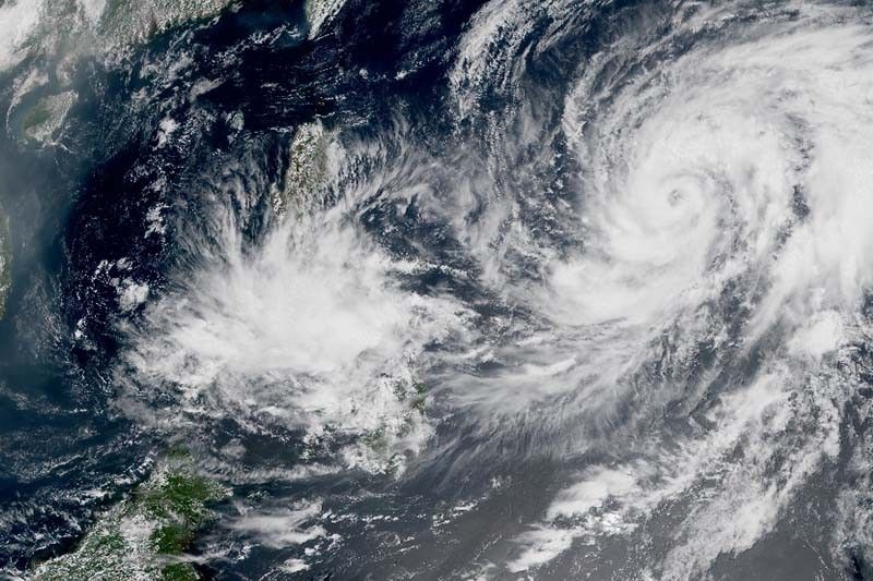
Cyclone Malakas, now intensified to typhoon status, entered the Philippine Area of Responsibility Tuesday morning and was named 'Basyang'.
This means there are two cyclones inside the country’s jurisdiction.
As of 10 a.m., the Basyang was about 1,435 kilometers east of Southern Luzon and heading north northwest at 20 kph, according to the state weather bureau.
It has peak winds of 120 kph near the center and gusts of up to 150 kph.
The typhoon is not expected to have direct effects on the weather and sea conditions of the country, PAGASA said.
“However, swells resulting from this tropical cyclone is forecast to generate moderate to rough seas over the northern and eastern seaboards of Luzon and the eastern seaboards of Visayas and Mindanao. These conditions may be risky for those using small seacrafts,” it warned.
Forecasters added the stay of Basyang will be brief and it may exit the PAR region Tuesday evening. The typhoon is expected to continue its intensification and may reach a peak intensity of 150 kph Wednesday morning.
The Philippines, one of the most vulnerable nations to the impacts of human-induced climate change, is hit by an average of 20 cyclones every year.
Forecast track of Agaton
• Tuesday evening: Over the coastal waters of Guiuan, Eastern Samar
• Wednesday morning: 195 km of Guiuan, Eastern Samar
Forecast track of Basyang
• Wednesday morning: 1,515 km east of Northern Luzon (outside PAR)
• Thursday morning: 1,650 km east of extreme Northern Luzon (outside PAR)
• Friday morning: 1,955 km east northeast of extreme Northern Luzon (outside PAR)
• Saturday morning 2,660 km east northeast of extreme Northern Luzon (outside PAR)
— Gaea Katreena Cabico
Typhoon Basyang (international name Malakas) is the second tropical cyclone to enter the Philippines in 2022. Bookmark this page for updates. — Main photo: JTWC
Typhoon Malakas, formerly "Basyang," was located 1,545 km east of Central Luzon (outside PAR) at 3 a.m., state forecasters say.
The tropical cycline packs winds of 150 kph and gustiness of up to 185 kph.
It is moving northeast at 10 kph.
Typhoon Basyang has left the Philippine Area of Responsibility at 1 p.m., state weather bureau PAGASA says in its 5 p.m. bulletin.
Basyang will continue to intensify and may reach a peak intensity of 155 kph by Wednesday afternoon.
At 4 p.m., the tropical cyclone was located 1,400 km east of Central Luzon with winds of 130 kph and gusts of up to 160 kph.
Typhoon Malakas (international name) entered the Philippine Area of the Philippines at 10 a.m., state weather bureau PAGASA says.
The tropical cyclone will be called Basyang.
At 10:00 AM today, Typhoon MALAKAS has entered the Philippine Area of Responsibility and was named #BasyangPH. Tropical Cyclone Bulletins will be issued beginning at 11:00 AM today. pic.twitter.com/OOf07gqHlQ
— PAGASA-DOST (@dost_pagasa) April 12, 2022


- Latest
- Trending


