


Signal No. 3 up in 7 areas as ‘Ursula’ makes landfall over Eastern Samar
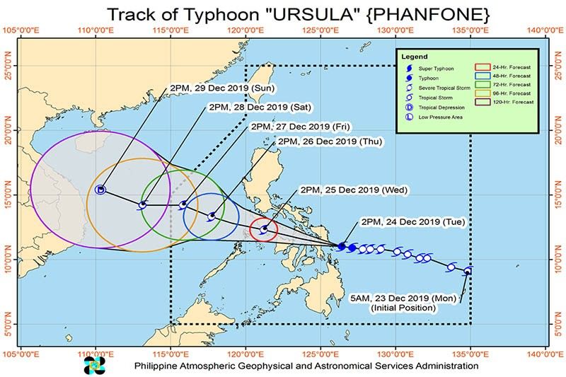
MANILA, Philippines— Typhoon “Ursula” (International name: Phanfone) made its first landfall over Eastern Samar on Tuesday afternoon, PAGASA said.
At 4:45 p.m., the eye of “Ursula” was over Salcedo, Eastern Samar.
The state weather bureau said following the landfall, the eyewall of the typhoon is bringing violent winds over the southern portion of Eastern Samar.
It added that it is likely to affect Biliran, the southern portion of Samar, and northern portion of Leyte in the next hours.
At 4 p.m., “Ursula’s” eye was traced at 20 kilometers East Northeast of Guiuan, Eastern Samar.
The typhoon packs maximum sustained winds of up to 120 km per hour near the center and gustiness of up to 150 kph.
Ursula is seen moving west at 25 kph.
According to PAGASA, the areas of Dinagat Islands, Siargao and Bucas Grande Islands, Eastern Visayas, Sorsogon, Masbate, northern and central Cebu, northern Negros Provinces, Aklan, Antique, Capiz, Iloilo, Guimaras and Romblon may experience occasional to frequent heavy rains between today and tomorrow noon.
On the other hand, the areas of Bicol Region, Quezon, Marinduque, Oriental Mindoro, and the rest of Visayas and Surigao del Norte would experience light to moderate with intermittent heavy rains.
Meanwhile, PAGASA also forecast occasional to frequent heavy rains over Aklan, Antique, Capiz, Romblon, Marinduque, Oriental Mindoro, Occidental Mindoro, Batangas, and Calamian Islands between Christmas day, Wednesday and late evening.
The weather agency said Cuyo Islands, Negros Provinces, Iloilo, Guimaras, Aurora, and the rest of CALABARZON would experience light to moderate with intermittent heavy rains.
In its 5 p.m. advisory, PAGASA said storm signals remain up over several areas.
TCWS No. 3 (121 to 170 kph winds prevailing or expected in 18 hours)
- Masbate including Ticao Island
- Northern Samar
- Samar
- Eastern Samar
- Biliran
- Leyte
- Extreme Northern Cebu including Camotes Island (Daaanbantayan, Medellin, Bantayan, Sta. Fe, Madridejos, San Francisco, Poro, Tudela, Pilar)
TCWS No. 2 ( 61 to 120 kph winds prevailing or expected in 24 hours)
-
Southern portion of Quezon (Mulanay, San Narciso, San Andres, San Francisco)
-
Marinduque
-
Oriental Mindoro
-
Occidental Mindoro including Lubang Island
-
Romblon
-
Albay
-
Sorsogon
-
Burias Island
-
Calamian
-
Cuyo Islands
-
Central portion of northern Cebu (Bogo City, Tabogon, Tabuelan, Borbon)
-
Northeastern Iloilo (Carles, Balasan, Estancia, Batad, San Dionisio, Sara, Concepcion, Lemery, Ajuy)
-
Northern Antique (Libertad, Pandan, Sebaste, Culasi, Tibiao)
-
Capiz
-
Aklan
-
Southern Leyte
-
Northern Negros Occidental (Enrique B. Magalona, Victorias, Manapla, Cadiz, Sagay, Escalante, Toboso)
-
Dinagat Islands
TCWS No. 1 (30-60 kph winds prevailing or expected in 36 hours)
-
Bulacan
-
Bataan
-
Metro Manila
-
Rizal
-
Cavite
-
Rest of Quezon
-
Laguna
-
Batangas
-
Camarines Sur
-
Camarines Norte
-
Catanduanes
-
Northern Palawan (Linapacan, El Nido, Taytay, Araceli, Dumaran, San Vicente, Roxas)
-
Rest of Cebu
-
Bohol
-
Siquijor
-
The rest of Antique
-
The rest of Iloilo
-
Guimaras
-
Negros Oriental
-
The rest of Negros Occidental
-
Surigao del Norte including Siargao and Bucas Grande Islands
—Rosette Adel


- Latest
- Trending


