More areas under Signal No. 2 as ‘Jenny’ nears land
MANILA, Philippines (Update 1 9:31 p.m.) — Ten provinces are now placed under Tropical Cyclone Wind Signal No. 2 as Tropical Storm Jenny (international name: Podul) continues to inch toward the Philippine landmass.
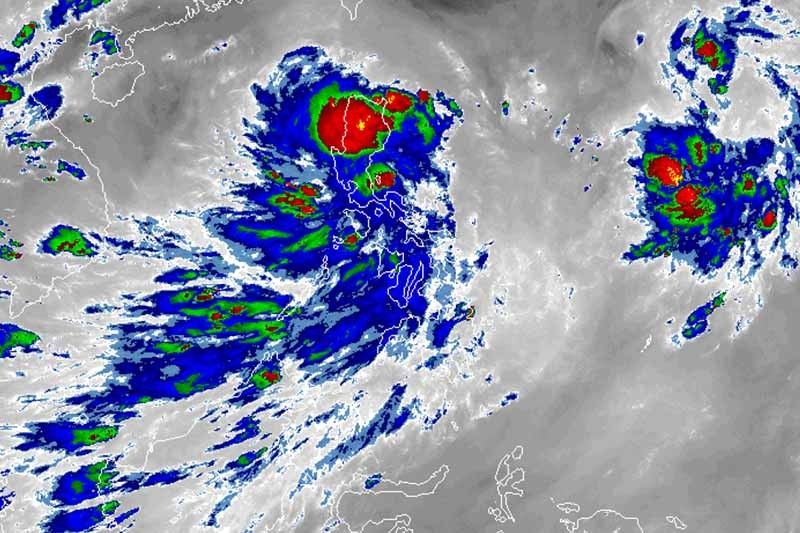
The eye of “Jenny” was located 210 km east-northeast of Infanta, Quezon or 210 km east of Baler, Aurora at 7 p.m on Tuesday. It packs maximum sustained winds of up to 65 kph near the center and gusts of up to 80 kph.
In its 8 p.m severe weather bulletin, PAGASA raised TCWS No. 2 over:
- Isabela
- Aurora
- Quirino
- Nueva Vizcaya
- Mountain Province
- Ifugao
- Benguet
- Ilocos Sur
- La Union
- Pangasinan
Residents of these areas may experience winds between 61 kph and 120 kph in at least 24 hours.
TCWS No. 1, meanwhile, is up over the following areas:
- Cagayan
- Apayao
- Abra
- Kalinga
- Ilocos Norte
- Nueva Ecija
- Tarlac
- Zambales
- Bataan
- Pampanga
- Bulacan
- Metro Manila
- Rizal
- Northern portion of Quezon including Polillo Islands and Alabat Island
- Cavite
- Laguna
- Camarines Norte
- Northeastern portion of Camarines Sur
- Catanduanes
Winds between 30 and 60 kph or intermittent rains may be expected in these areas within 36 hours.
PAGASA warned that sea travel remains dangerous over the seaboards of areas under TCWS and seaboards of Batanes.
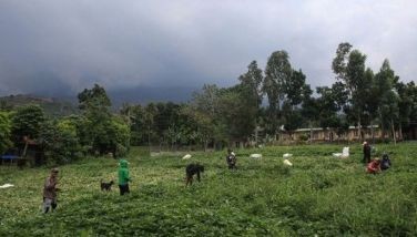
Occasional gusty conditions are also possible in the Visayas and other areas of Luzon due to the southwest monsoon.
Landfall between Tuesday night and Wednesday morning
Moving west-northwest at 35 kph, Tropical Storm Jenny may make landfall over Aurora province between 9 p.m. Tuesday and 1 a.m. Wednesday.
Weather forecasters said “Jenny” would cross parts of central and northern Luzon before exiting the Philippine landmass Wednesday morning.
If it maintains its track and speed, the tropical storm may leave the Philippine area of responsibility Thursday.
Rainy week
PAGASA said that intermittent to frequent moderate to heavy rains may be experienced over Cordillera Administrative Region, Isabela, Cagayan, Quirino, Nueva Vizcaya, Aurora, Nueva Ecija and the northern portion of Quezon between Tuesday afternoon and Wednesday morning.
Meanwhile, light to moderate with intermittent heavy rains may affect Metro Manila, Central Visayas, Western Visayas, Northern Mindanao, Zamboanga Peninsula and the rest of Luzon.
Between Wednesday morning and Thursday morning, light to moderate with intermittent to occasionally heavy rains may prevail over Metro Manila, Western Visayas, Mindoro provinces, the northern portion of Palawan (including Calamian and Cuyo Islands), Zambales and Bataan.
Forecast positions
- Wednesday afternoon: 320 km west-northwest of Dagupan City, Pangasinan
- Thursday afternoon: 870 km west of Sinait, Ilocos Sur (outside the Philippine area of responsibility)
— Gaea Katreena Cabico
A Low Pressure Area east of Virac, Catanduanes has developed into a tropical depression and will be called "Jenny," PAGASA says.
The weather bureau will issue its first Severe Weather Bulletin on Tropical Depression Jenny at 5 p.m. on Monday, August 26.
Follow this thread for updates.
The state weather bureau reports that as of 2 p.m., the Low Pressure Area East of Central Luzon entered the Philippine Area of Responsibility.
It developed into Tropical Depression Jenny.
Tropical Storm Jenny (international name: Podul) is now outside the Philippine area of responsibility. It exited at 2 p.m. Wednesday, August 28, and is now headed to Hainan, China.
Tropical Storm Jenny is forecast to make landfall in the vicinity of Casiguran, Aurora in the next two hours, PAGASA says in its 11 p.m. severe weather bulletin.
Once it hits land, it is likely to weaken into a tropical depression.
As of 8 p.m., 10 areas are under Signal No. 2 while 19 are placed under Signal No. 1 due to "Jenny."
PAGASA raised Signal No. 2 over Isabela, Aurora, Quirino, Nueva Vizcaya, Mountain Province, Ifugao, Benguet, Ilocos Sur, La Union and Pangasinan.
Meanwhile, Signal No. 1 is hoisted over Cagayan, Apayao, Abra, Kalinga, Ilocos Norte, Nueva Ecija, Tarlac, Zambales, Bataan, Pampanga, Bulacan, Metro Manila, Rizal, northern portion of Quezon including Polillo Islands and Alabat Island, Cavite, Laguna, Camarines Norte, northeastern portion of Camarines Sur, Catanduanes
PAGASA hoisted Signal No. 2 in three more provinces, raising the areas under this signal to six: Isabela, Aurora, Quirino, Nueva Vizcaya, Ifugao and Mountain Province.
These areas, on the other hand, are under Signal No. 1:
- Cagayan
- Apayao
- Abra
- Kalinga
- Benguet
- Ilocos Norte
- Ilocos Sur
- La Union
- Pangasinan
- Nueva Ecija
- Tarlac
- Zambales
- Bataan
- Pampanga
- Bulacan
- Metro Manila
- Rizal
- Northern portion of Quezon including Polillo Islands and Alabat Island
- Cavite
- Laguna
- Camarines Norte
- Northeastern portion of Camarines Sur
- Catanduanes


- Latest
- Trending