'Goring' now a super typhoon; Parts of Isabela under Signal No. 3
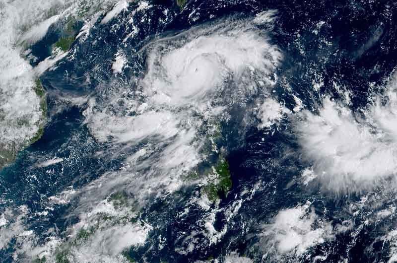
MANILA, Philippines — Cyclone Goring (international name: Saola) has intensified into a super typhoon Sunday morning, and will bring heavy rain and strong winds to parts of northeastern Luzon, the state weather bureau said.
Goring was last spotted over the coastal waters of Palanan in Isabela, with peak winds of up to 185 kilometers per hour near the center and gusts of up to 230 kph.
PAGASA said the slow-moving cyclone will remain a super typhoon until it makes landfall over southern Taiwan on Wednesday or Thursday.
The following areas were placed under Tropical Cyclone Wind Signals:
Signal No. 3
- Extreme eastern portion of Isabela (Divilacan, Palanan)
Storm-force winds may cause moderate to significant impacts in these areas.
Signal No. 2
- Eastern portion of mainland Cagayan (Peñablanca, Baggao, Gattaran, Lal-Lo, Gonzaga, Santa Teresita, Buguey, Santa Ana)
- Eastern portion of Isabela (Dinapigue, Ilagan City, Maconacon, Cabagan, Tumauini, San Pablo, Benito Soliven, San Mariano)
- Extreme northern portion of Aurora (Dilasag, Casiguran)
Minor to moderate impacts from gale-force winds are possible in these areas.
Signal No. 1
- Babuyan Islands
- Rest of mainland Cagayan
- Rest of Isabela
- Quirino
- Nueva Vizcaya
- Apayao
- Kalinga
- Abra
- Mountain Province
- Ifugao
- Eastern portion of Benguet (Bokod, Buguias, Kabayan, Mankayan)
- Eastern portion of Ilocos Norte (Pagudpud, Adams, Vintar, Carasi, Nueva Era, Banna, Marcos, Dingras, Solsona, Piddig, Dumalneg, Bangui)
- Northeastern portion of Nueva Ecija (Carranglan, Pantabangan, Bongabon, Gabaldon, Laur, Rizal)
- Northern and central portions of Aurora (Dinalungan, Dipaculao, Baler, Maria Aurora, San Luis)
- Polillo Islands
- Calaguas Islands.
Minimal to minor impacts from strong winds are also possible within any of the areas under Signal No. 1.
What to expect
According to PAGASA, the super typhoon will dump an accumulated rainfall of more than 200 millimeters over the eastern portion of Isabela.
The eastern portions of mainland Cagayan and Isabela will have an accumulated rainfall of 100 to 200 mm, while Ilocos region, Apayao, Abra, Bengue, northern portion of Aurora, eastern portion of Nueva Vizcaya, and rest of mainland Cagayan and Isabela will have an accumulated rainfall of 50 to 100 mm.
The weather agency warned that floods and landslides may occur in areas that are susceptible to these hazards and in localities that experienced significant rainfall for the past few days.
Goring will also enhance the southwest monsoon, which will bring occasional or monsoon rains over the western portions of Central Luzon, Southern Luzon, and Visayas over the next three days.
The enhanced southwest monsoon will continue to bring gusty conditions over the following areas that are not under any wind signal: Aurora, Bataan, Metro Manila, Calabarzon, Mimaropa, Bicol region, Visayas, Dinagat Islands, and Camiguin.
PAGASA warned that the condition of the northern and eastern coastal waters of Luzon is “hazardous.”
Goring is forecast to begin its loop over the Philippine Sea east of Cagayan-Isabela area before heading north to Taiwan. It is likely that the cyclone will exit the Philippine Area of Responsibility as a severe tropical storm or a minimal typhoon.
Forecast position
- August 27, 2023 2:00 PM - 155 km east northeast of Casiguran, Aurora
- August 28, 2023 2:00 AM - 250 km east northeast of Casiguran, Aurora
- August 28, 2023 2:00 PM - 355 km east of Tuguegarao City, Cagayan
- August 29, 2023 2:00 AM - 370 km east of Aparri, Cagayan
- August 29, 2023 2:00 PM - 310 km east of Calayan, Cagayan
- August 30, 2023 2:00 AM - 150 km east of Basco, Batanes
- August 31, 2023 2:00 AM - 250 km north northwest of Itbayat, Batanes or in the vicinity of Pingtung County, Taiwan
- September 1, 2023 2:00 AM - 250 km north northwest of Itbayat, Batanes (OUTSIDE PAR)
— Gaea Katreena Cabico


- Latest
- Trending