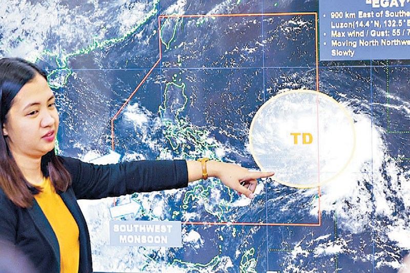
Pagasa: Egay may develop into super typhoon

MANILA, Philippines — The Philippine Atmospheric, Geophysical and Astronomical Services Administration (PAGASA) yesterday said that a low-pressure area (LPA) east of Southern Luzon has developed into Tropical Depression Egay and may turn into a super typhoon, adding that many areas in the country should prepare for the potential cyclone that has a radius of 550 kilometers.
PAGASA weather specialist Ana Clauren-Jorda said that Egay will also enhance the southwest monsoon.
“In terms of intensity of Tropical Depression Egay, it is expected to develop into tropical storm category within the next 24 hours and by tomorrow (Saturday) it is possible (to) develop into a severe tropical storm. By Sunday, it will develop into a typhoon category and by Monday, it is possible it will reach the super typhoon category,” Clauren-Jorda said.
Under PAGASA’s tropical cyclone wind signal system, a super typhoon is declared if it has sustained winds of 185 kilometers per hour; typhoon, 118 to 184 kph; severe tropical storm, 89 to 117 kph; tropical storm, 62 to 88 kph, and tropical depression less than 61 kph.“We should take seriously the threat of Tropical Depression Egay as its wide diameter of 550 kilometer radius, with strong winds where it can reach super typhoon category and the amount of rains it will bring,” Clauren-Jorda said.She added that heavy rains are expected in the western section of Southern Luzon and the Visayas amid the effects of Egay and the enhanced southwest monsoon.According to Clauren-Jorda, the tropical depression’s presence will start to be felt from Sunday to Monday in Catanduanes and Northern Samar, where rains will reach 50 to 100 millimeters.“As Tropical Depression Egay will enhance the southwest monsoon this Sunday, we expect strong rains in areas in Mimaropa and the Visayas. From Monday until Tuesday, monsoon rains will continue to affect the western section of Southern Luzon and Western Visayas. We advise the affected residents to take extra precaution as the southwest monsoon will prevail until next week,” she added.
Clauren-Jorda said the weather bureau will start to raise tropical cyclone wind signals in the Bicol region and Eastern Visayas, particularly the eastern portion, starting Saturday evening or early Sunday.
“The southwest monsoon will also bring strong rains in the Mimaropa, Western Visayas and western portion of Mindanao starting Saturday afternoon or Sunday evening,” she said.?She added that Tropical Depression Egay will also cause moderate to rough seas where waves in Southern Luzon and Eastern Visayas could reach as high as 3.5 meters by Sunday.
“We do not discount the possibility of raising gale warning in the western section of the country,” Clauren-Jorda said.
According to her, Egay is moving west northwestward in the next 24 hours and by Saturday, it is possible that it will move northwestward.“Tropical Depression Egay is expected to further gain strength in the next few days as it is still over the ocean,” she said.Clauren-Jorda said that Egay is expected to make landfall in Cagayan and Batanes.“By Monday, it is possible the center of Tropical Depression Egay will be nearer Philippine landmass and we are not discounting the possibility that it will make landfall, particularly in mainland Cagayan and Batanes areas over the weekend or early Monday, or early next week,” she said.Clauren-Jorda said that Egay was last located 900 kilometers east of Southeastern Luzon with maximum sustained winds of 55 kph near the center and gustiness of up to 70 kph.
Meanwhile, the Philippine Institute of Volcanology and Seismology (Phivolcs) has warned of lahar flow from Mayon Volcano in Albay as Tropical Depression Egay threatens the Philippines.Based on the latest bulletin of Phivolcs yesterday, Egay is expected to cause prolonged and heavy rainfall which may generate lahar along major channels of Mayon Volcano.“Due to this development, communities in predetermined areas with lahar hazards from Mayon Volcano are strongly recommended to be vigilant and ready,” Phivolcs said. — Cet Dematera
- Latest
- Trending


