FalconPH
Tropical Storm Falcon is now outside the Philippine area of responsibility, PAGASA says in its 5 p.m. severe weather bulletin.
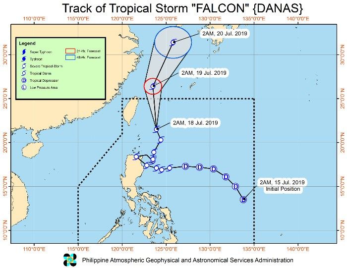
"Falcon's" center was estimated at 655 km north-northeast of Basco, Batanes at 4 p.m. today. It packs maximum sustained winds of up to 80 kph near the center and gustiness of up to 100 kph. It is moving north at 25 kph.
Meanwhile, the LPA outside PAR it is monitoring was estimated based on all available data at 310 km west-northwest of Sinait, Ilocos Sur at 3 p.m. today. This LPA may develop into a tropical depression within 36 hours.
'Falcon' has maintained strength and continues to move north, PAGASA says in its early morning Severe Weather Bulletin.
As of early Thursday, the tropical storm was 230 kilometers northeast of Basco, Batanes—the northernmost province in Luzon. It is moving north at 20 kilometers per hour.
'Falcon' has maximum sustained winds of up to 65 kph near the center and gustiness of up to 80 kph.
"Today, moderate to at times heavy rains will be experienced over Ilocos Region, Zambales, Bataan, Cavite, Batangas, Occidental Mindoro, and northern Palawan including Calamian and Cuyo Islands. Meanwhile, light to moderate to at times heavy rains will be experienced over Metro Manila and the rest of Luzon," PAGASA also says.
Tropical Storm Falcon maintains its strength as it tracks northward, according to a 5 a.m. PAGASA bulletin. Its center was spotted at 230 kilometers northeast of Basco, Batanes at 4 a.m. today with maximum winds of 65 kph near the center and gusts of 80 kph.
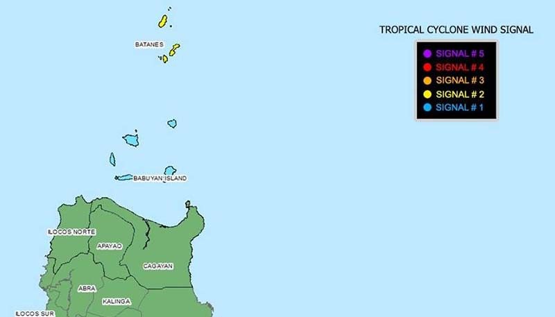
Batanes is still under Tropical Cyclone Warning Signal No. 2, while Signal No. 1 is hoisted over the Babuyan Group of Islands,
Tropical Storm Falcon maintains its strength as it tracks northward, according to a 5 a.m. PAGASA bulletin. Its center was spotted at 230 kilometers northeast of Basco, Batanes at 4 a.m. today with maximum winds of 65 kph near the center and gusts of 80 kph.
Batanes is still under Tropical Cyclone Warning Signal No. 2, while Signal No. 1 is hoisted over the Babuyan Group of Islands,

Tropical Storm Falcon has maintained its strength with maximum sustained winds of 65 kph and gusts of 80 kph.
As of 4 p.m., "Falcon's" eye was located at 265 km east of Calayan, Cagayan.
Signal No. 2 is still up over Batanes while Signal No. 1 is raised over Apayao, Cagayan, Ilocos Norte and Babuyan Group of Islands.
Classes on July 17, Wednesday, have been suspended in all levels in the following areas due to Tropical Storm Falcon:
National Capital Region
- Caloocan
- Las Piñas
- Makati
- Malabon
- Mandaluyong
- Manila
- Marikina
- Muntinlupa
- Navotas
- Parañaque
- Pasay
- Pasig
- Pateros
- Quezon City
- San Juan City
- Taguig City
- Valenzuela City
Abra
Apayao
Bataan
Batangas
- Balete
- Calaca
- Calatagan
- Laurel
- Lemery
- Lian
- San Luis
- Taal
- Tanauan
- Tingloy
Benguet
- Itogon
Bulacan
- Bulakan
Cagayan
Camarines Sur
Cavite
Ilocos Sur
- Burgos
- Caoayan
- Sinait
- Sta Cruz
- Sugpon
Isabela
La Union
- Caba
- Pugo
- San Gabriel
Negros Occidental
- Bago City
- Binalbagan
- Himamaylan City
- Hinoba-an
- Cadiz City
- Ilog
- Isabela
- La Castellana
- Moises Padilla
- Murcia
- Pontevedra
- Pulupandan
- San Carlos City
- Sipalay City
- Talisay City
- Valladolid
Nueva Ecija
- Cuyapo
Pangasinan
- Aguilar
- Bani
- Binmaley
- Bugallon
- Burgos
- Labrador
- Laoac
- Lingayen
- Mabini
- Manaoag
- Mangaldan
- Mapandan
- Sto Tomas
- Urbiztondo
Romblon
- Ferrol
- San Andres
Tarlac
- Anao
- Bamban
- Capas
- Concepcion
Zambales
- Olongapo City
- Subic
"Falcon" (international name: Danas) intensifies into a tropical storm as it continues to move westward.
PAGASA in its 5 p.m. severe weather bulletin says "Falcon" developed into a tropical storm at 2 p.m. today.
Signal No. 2 is up over the northeastern portion of Cagayan including Babuyan Group of Islands while Signal No. 1 is raised over Batanes, rest of Cagayan, northern portion of Ilocos Norte, northern portion of Abra, Apayao, Kalinga, Isabela, eastern portion of Mt. Province and the eastern portion of Ifugao.
Signal No. 1 may be raised over the northern portions of Aurora, Quirino and Nueva Vizcaya and the rest of Abra, Mt. Province and Ifugao in the succeeding bulletins.
"Falcon" is expected to closely approach or make landfall over Babuyan-Batanes Islands area tomorrow evening and may exit the Philippine area of responsibility on Friday, July 19.
Its eye was located at 335 km east-southeast of Tuguegarao City, Cagayan at 4 p.m. today.
Classes have been suspended in the following areas due to inclement weather brought by Tropical Depression Falcon:
All levels:
- Biliran
- Dinagat, Dinagat Islands (island barangays)
- San Jose, Dinagat Islands
Pre-school to elementary
Basilisa, Dinagat Islands
Pre-school to high school
Babatngon, Leyte
Pre-school to senior high school
- San Fernando, Romblon
- San Miguel, Leyte
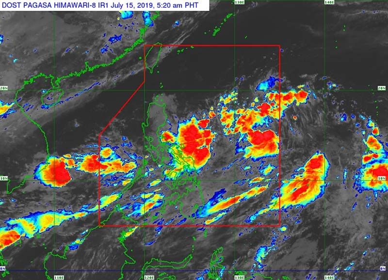
The low pressure area that PAGASA was monitoring off Guiuan, Eastern Samar has developed into a tropical depression, which is now designated "Falcon".
According to the latest weather update, the tropical depression was 990 km east of Virac, Catanduanes as of early Monday morning. "Falcon" has maximum sustained winds of 45 kph near the center and gustiness of up to 60 kph.
It is moving north northwest at 20 kph.
No tropical storm warning signals have been raised yet, but PAGASA says Bicol and Eastern Visayas can expect scattered rainshowers and thunderstorms brought by the tropical depression. MIMAROPA, the rest of the Visayas and Mindanao will also see similar weather because of the Southwest Monsoon.
"Residents in the aforementioned areas, especially those living in areas identified to be at risk of flooding and landslides, are advised to take precautionary measures, coordinate with local disaster risk reduction and management offices, and continue monitoring for updates, especially the Thunderstorm Advisories and Heavy Rainfall Warnings to be issued by PAGASA Regional Services Divisions," PAGASA says.


- Latest
- Trending