


12 areas under Signal No. 1 as 'Aghon' keeps strength
MANILA, Philippines — Twelve areas in Luzon, Visayas and Mindanao have been placed under Signal No. 1 on Friday morning due to Tropical Depression Aghon.
State weather bureau PAGASA hoisted Signal No. 1 over the following areas:
Luzon
- Sorsogon
- Albay (Manito, Legazpi City, City of Tabaco, Rapu-Rapu, Santo Domingo, Malilipot, Bacacay, Malinao, Tiwi)
- Catanduanes
- Camarines Sur (Caramoan, Garchitorena, Presentacion, Sagñay, San Jose, Lagonoy, Tigaon)
Visayas
- Eastern Samar
- Samar
- Northern Samar
- Leyte (Babatngon, Tacloban City, Palo, Tanauan, Tolosa, Dulag, Mayorga, Macarthur, Abuyog, Javier)
- Southern Leyte (Silago, Hinunangan, Hinundayan, Anahawan, San Juan, Liloan, Saint Bernard, San Ricardo, Pintuyan, San Francisco)
Mindanao
- Dinagat Islands
- Surigao del Norte including Siargao - Bucas Grande Group
- Surigao del Sur (Carrascal, Cantilan, Madrid, Carmen, Lanuza, Cortes, City of Tandag)
Residents of these areas may expect winds of 30 to 60 kilometers per hour or intermittent rains within 36 hours.
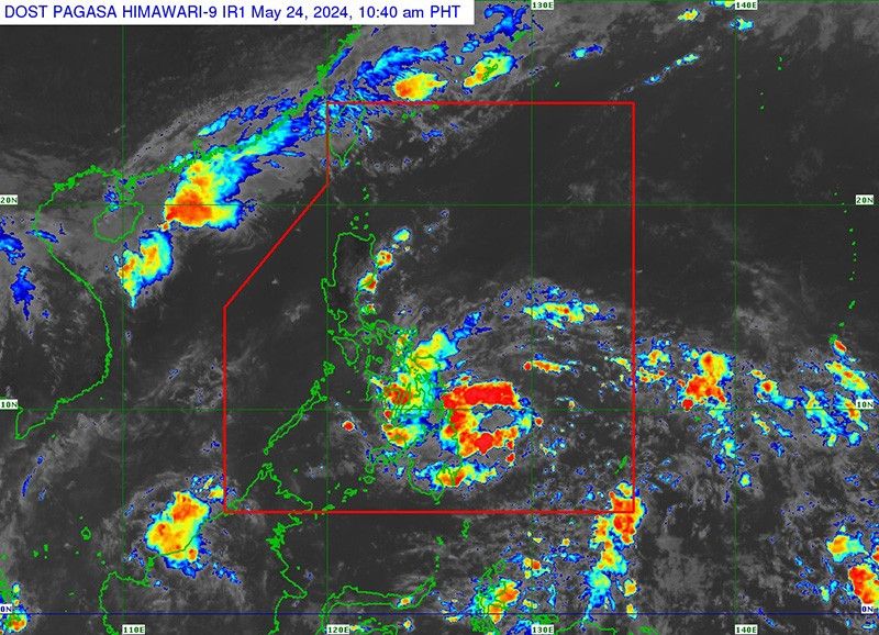
"Aghon"—the first tropical cyclone to enter the Philippine area of responsibility—was last seen 605 km east of Hinatuan, Surigao del Sur, as of 10 a.m. Friday.
It has winds of 45 kilometers per hour and gusts of up to 55 kph.
Heavy rainfall outlook
Aghon is expected to bring significant rainfall and strong winds to parts of the Eastern Visayas and Bicol Region over the coming days.
From Friday until Saturday noon:
- 100-200 mm: Eastern Samar, Southern Leyte, Surigao del Norte, Dinagat Islands
- 50-100 mm: Surigao del Sur, rest of Eastern Visayas, Albay, Sorsogon, Masbate (including Ticao and Burias Islands), Catanduanes, eastern portion of Camarines Sur
From Saturday noon to Sunday noon:
- 100-200 mm: Northern Samar, Albay, Sorsogon, Masbate (including Ticao and Burias Islands), Catanduanes, Camarines Sur
- 50-100 mm: Camarines Norte, rest of Eastern Visayas, southern portion of Quezon (including Polillo Islands)
From Sunday noon to Monday noon:
- 50-100 mm: Catanduanes, Camarines Norte, Camarines Sur
"Forecast rainfall are generally higher in elevated or mountainous areas. Under these conditions, flooding and rain-induced landslides are possible especially in areas that are highly or very highly susceptible to these hazards as identified in hazard maps and in localities that experienced considerable amounts of rainfall for the past several days," PAGASA said.
Hazards affecting coastal waters
Tropical Depression AGHON is expected to cause moderate to rough seas (1.5 to 3.0 meters) along the northern and eastern seaboards of Eastern Visayas and the eastern seaboard of the Caraga Region.
Mariners operating motor bancas and similarly-sized vessels are advised to take precautionary measures and avoid navigating these waters if possible, especially if inexperienced or operating ill-equipped vessels.
Track and intensity outlook
Aghon is expected to move generally west northwestward or northwestward from Friday until Saturday while slowly intensifying.
"On the track forecast, Aghon is forecast to make a close approach or make landfall in the vicinity of Eastern Visayas tomorrow morning as a tropical storm," the state weather bureau said.
PAGASA said an earlier landfall over Eastern Visayas and a direct passage near the Bicol Region are possible given the trend of a westward shift in Aghon's track and the forecast probability cone.
Forecast position
- May 24, 2024 08:00 p.m.: 220 km east of Surigao City, Surigao del Norte
- May 25, 2024 08:00 a.m.: 65 km east northeast of Guiuan, Eastern Samar
- May 25, 2024 08:00 p.m.: 65 km east northeast of Virac, Catanduanes
- May 26, 2024 08:00 a.m.: 170 km northeast of Daet, Camarines Norte
- May 26, 2024 08:00 p.m.: 230 km east of Casiguran, Aurora
- May 27, 2024 08:00 a.m.: 335 km east of Tuguegarao City, Cagayan
- May 28, 2024 08:00 a.m.: 705 km east northeast of Itbayat, Batanes
- May 29, 2024 08:00 a.m.: 1,670 km northeast of extreme Northern Luzon (outside PAR)


- Latest
- Trending


