Philippines rejects China’s expanded 10-dash line in SCS
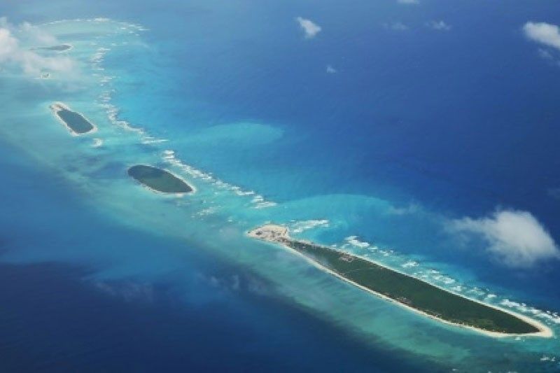
MANILA, Philippines — Manila has lodged a protest against China’s release of its supposed new standard map, which shows an even bigger coverage of waters and land features within Philippine territory.
In a statement yesterday, the Department of Foreign Affairs (DFA) said the Philippines rejects the 2023 version of China’s Standard Map – now showing a 10-dash line – issued by the Ministry of Natural Resources of China on Aug. 28.
Beijing’s claim in the South China was originally based on its so-called nine-dash line. The new map includes Taiwan. India has also protested Beijing’s new map, while Malaysia vowed to file its own protest.
“This latest attempt to legitimize China’s purported sovereignty and jurisdiction over Philippine features and maritime zone has no basis under international law, particularly the 1982 United Nations Convention on the Law of the Sea (UNCLOS),” the DFA said.
In a landmark ruling on July 12, 2016, the Permanent Court of Arbitration based in The Hague found no legal basis for China to claim “historic rights” over almost the entire South China Sea.
“The 2016 Arbitral Award invalidated the nine-dashed line. It categorically stated that maritime areas of the South China Sea encompassed by the relevant part of the ‘nine-dash line’ are contrary to the Convention and without lawful effect to the extent that they exceed the geographic and substantive limits of China’s maritime entitlements under the Convention,” the DFA said.
“The Philippines, therefore, calls on China to act responsibly and abide by its obligations under UNCLOS and the final and binding 2016 Arbitral Award,” it said.
India has protested the inclusion of its Aksai Chin region and its northeastern state of Arunachal Pradesh in the Chinese map.
Asked to react to China’s new map, National Security Adviser Eduardo Año said the 2016 arbitral ruling is “final and binding” and gave assurance that the government would protect the Philippines’ territory and sovereignty.
“We do not recognize the 10-dash line. We do not even recognize the nine-dash line, much more the 10-dash line. The arbitral award is final and binding and it gives us our maritime entitlement, our extended economic zone, our territorial waters and even our extended continental shelf,” Año said at a press briefing.
“We will continue to protect our territorial integrity and our national sovereignty. Our armed forces, our uniformed services, our government will do everything in its capacity to ensure that we are protecting our national interest,” he added.
China released the new map ahead of the Association of Southeast Asian Nations Summit in Indonesia.
Galvanize support for Philippines
At a press briefing, Senate President Juan Miguel Zubiri said China’s new standard map would only galvanize support for the Philippines’ sovereign rights over the West Philippine Sea and isolate China in the eyes of the world. He said China has even antagonized India, its partner in the BRICS (Brazil, Russia, India, China, South Africa) economic bloc.
“Misery loves company. The criticisms over their expansive 10-dash line will solidify support for the arbitral ruling, which quashed the previous nine-dash line. More countries will support the Philippines in condemning that ridiculous 10-dash line,” Zubiri said.
Sen. Francis Tolentino, at a separate briefing, said China’s release of a new map was part of its “aggressive expansion.”
He vowed to expedite the passage of the law that will delineate the country’s internal waters, territorial sea, contiguous zone, exclusive economic zone (EEZ) and continental shelf, pending before the Senate special committee on Philippine maritime and admiralty zones.
“We should prioritize the maritime zone bill, because China’s 10-dash line is inching closer to Batanes,” Tolentino said.
Sen. Risa Hontiveros, for her part, called China “delusional” as she urged the National Mapping and Resource Information Authority to come up with a map that shows the country’s continental shelves and territorial seas within its EEZ.
“We know that China is a master manipulator, willing to bend the truth for her own gain, at the expense of countries like ours. China will continue to spread fake news, fund pro-Beijing mouthpieces, and distribute propaganda materials. We must push back. We must not rest until China stops her absurdity,” Hontiveros said. – Marc Jayson Cayabyab, Alexis Romero


- Latest
- Trending