Signal No. 2 up in parts of northern Luzon due to 'Betty'
MANILA, Philippines — State weather bureau PAGASA on Monday morning raised Tropical Cyclone Wind Signal No. 2 in parts of Northern Luzon as Typhoon Betty (international name: Mawar) sped up slightly over the waters east of Cagayan.
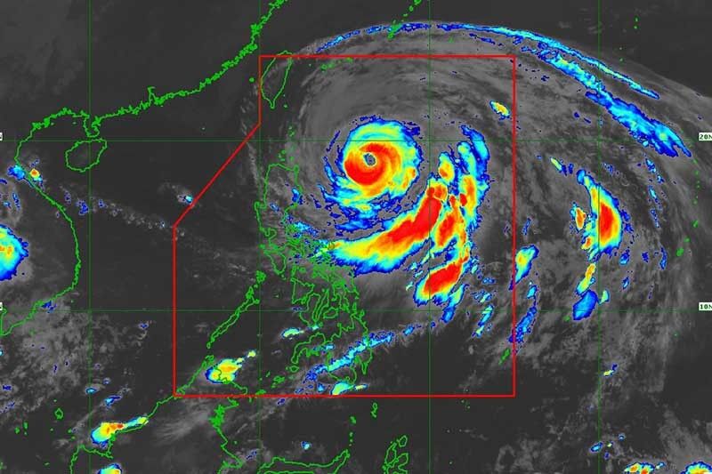
Betty was last seen 525 kilometers east of Aparri in Cagayan with peak winds of 155 kilometers per hour near the center and gusts of up to 190 kph. It was moving northwest at 20 kph.
PAGASA hoisted wind signals in parts of Luzon due to Betty.
Wind Signal No. 2
- Batanes
- Eastern portion of Babuyan Islands (Babuyan Island, Camiguin Island, Didicas Island, Pamuktan Island)
- Northeastern portion of mainland Cagayan (Santa Ana)
In areas under Signal No. 2, minor to moderate impacts caused by gale-force winds are likely. Rice and corn crops may be adversely affected.
Wind Signal No. 1
- Rest of Babuyan Islands
- Rest of mainland Cagayan
- Isabela
- Quirino
- Northeastern portion of Nueva Vizcaya (Kasibu, Quezon, Solano, Bagabag, Diadi, Villaverde, Bayombong, Ambaguio)
- Apayao
- Abra
- Kalinga
- Mountain Province
- Ifugao
- Ilocos Norte
- Northern and central portions of Aurora (Dilasag, Casiguran, Dinalungan, Dipaculao, Baler)
- Polillo Islands
- Northern portion of Catanduanes (Caramoran, Viga, Gigmoto, Panganiban, Bagamanoc, Pandan)
- Northeastern portion of Camarines Sur (Caramoan, Garchitorena, Lagonoy, Tinambac, Siruma)
- Northern portion of Camarines Norte (Vinzons, Paracale, Jose Panganiban, Capalonga, Talisay, Daet, Mercedes, Basud)
Winds brought by Betty may result in minimal to minor impacts in areas under Signal No. 1. Rice crops, however, may suffer significant damage when they are in the flowering stage.
What to expect
According to state meteorologists, those living in the eastern portion of Babuyan Islands and the northeastern portion of mainland Cagayan will experience rain between 50 and 100 millimeters until early Tuesday morning.
From Tuesday morning to early Wednesday morning, Betty will dump 100 to 200 millimeters of rain to Batanes and the eastern portion of Babuyan Islands.
The country’s second cyclone of the year is enhancing the southwest monsoon (habagat) this week. Monsoon rains are likely over the western portions of Mimaropa and Western Visayas by Tuesday.
PAGASA warned that flooding and landslides are likely under these conditions, especially in areas that are highly susceptible to these hazards and in areas that experienced considerable amounts of rainfall for the past several days.
Occasional gusts are possible in the eastern portion of Central Luzon, eastern and southern portions of Southern Luzon that are not under any wind signal, and most of Visayas as the cyclone enhances the southwest monsoon.
The state weather bureau said the typhoon may “steadily weaken over the next five days due to cooler ocean waters and dry air intrusion.” It may be downgraded into a severe tropical storm late Thursday or early Friday and into a tropical storm late Friday or early Saturday.
Betty is forecast to move generally northwestward slowly today and may become slow-moving or almost stationary from tomorrow to mid-Wednesday while over the waters east of Batanes. Then, it will gradually accelerate towards the waters east of Taiwan and the southern portion of Ryukyu Islands.
Betty may exit the Philippine Area of Responsibility Friday.
Forecast position
- May 29, 2023 2:00 PM - 445 km east of Calayan, Cagayan
- May 30, 2023 2:00 AM - 320 km east of Basco, Batanes
- May 30, 2023 2:00 PM - 265 km east of Basco, Batanes
- May 31, 2023 2:00 AM - 245 km east of Itbayat, Batanes
- May 31, 2023 2:00 PM - 250 km east northeast of Itbayat, Batanes
- Jun 01, 2023 2:00 AM - 290 km east northeast of Itbayat, Batanes
- Jun 02, 2023 2:00 AM - 530 km northeast of Itbayat, Batanes
- Jun 03, 2023 2:00 AM - 835 km northeast of Extreme Northern Luzon (outside PAR)
— Gaea Katreena Cabico


- Latest
- Trending