Red rainfall warning up over Batangas, parts of Quezon province
MANILA, Philippines — Weather forecasters issued on Wednesday morning heavy rainfall warnings over parts of Luzon due to Severe Tropical Storm Jolina (Conson).
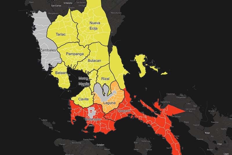
In an 8 a.m. advisory, PAGASA raised red rainfall warning over the following areas:
- Quezon (San Andres, San Francisco, Mulanay, San Narciso, Catanauan, Buenavista, Guinayangan, Lopez, General Luna, Tagkawayan, Calauag, Macalelon, Gumaca, Pitogo, Unisan, Plaridel, Agdangan, Atimonan, Padre Burgos, Pagbilao, Mauban, Sampaloc, Tayabas, Lucban, Sariaya, Candelaria, Dolores, Tiaong, San Antonio, Lucena, Perez, Alabat, Quezon)
- Batangas
A red rainfall warning is issued when observed rainfall is more than 30 millimeters within one hour or if downpour has continued for the past three hours and is more than 65 mm.
Under this, community response is needed as severe flooding is expected in flood-prone areas.
The state weather bureau also issued orange rainfall warning—or when rainfall is between 15 mm and 30 mm in an hour—over Laguna.
Flooding is threatening in areas under the orange alert.
Meanwhile, yellow rainfall warning was hoisted over the following areas:
- Metro Manila
- Tarlac
- Nueva Ecija
- Bataan
- Pampanga
- Bulacan
- Cavite
- Rizal
- Quezon (Real, Infanta, Polilio, Jomalig, Patnanungan, Burdeos, Panukulan, General Nakar)
This means the expected rainfall is between 7.5 mm and 15 mm within an hour. Flood is possible in flood-prone areas.
PAGASA also said that light to moderate with occasional heavy rains affecting Zambales may persist within three hours.
Jolina was last located over the coastal waters of San Juan, Batangas with peak winds of 95 kph and gusts of up to 115 kph. It is moving west northwest at 15 kph.

Follow this page for updates on Jolina, the tenth tropical cyclone to enter the Philippines on 2021. — Main photo from JTWC
Typhoon Kiko slightly weakens as it moves towards the Babuyan Islands-Batanes area, state weather bureau PAGASA says on Friday morning.
At 4 a.m., Kiko was located 280 km east northeast of Casiguran, Aurora with winds of 185 kph and gustiness of 230 kph.
Tropical cyclone wind signals are raised in the following areas:
Signal No. 3
- the extreme northeastern portion of Cagayan (Santa Ana)
Signal No. 2
- Batanes
- Babuyan Islands
- the remaining eastern portion of mainland Cagayan (Aparri, Camalaniugan, Lal-Lo, Gattaran, Baggao, Peñablanca, Buguey, Santa Teresita, Gonzaga)
- the northeastern portion of Isabela (San Pablo, Maconacon, Divilacan, Palanan)
Signal No. 1
- the rest of mainland Cagayan
- the northeastern portion of Ilocos Norte (Pagudpud, Adams, Dumalneg, Bangui, Vintar, Carasi)
- Apayao
- the eastern portion of Kalinga (City of Tabuk, Pinukpuk, Rizal)
- the northwestern and southeastern portions of Isabela (Santa Maria, Quezon, Mallig, Roxas, San Manuel, Cabatuan, Aurora, City of Cauayan, Angadanan, San Guillermo, Dinapigue, San Mariano, Cabagan, Santo Tomas, Delfin Albano, Tumauini, Quirino, Burgos, Gamu, Ilagan City, Luna, Reina Mercedes, Naguilian, Benito Soliven)
- the northern portion of Aurora (Dilasag, Casiguran)
All tropical cyclone wind signals have been lifted as Tropical Storm Jolina continues to move over the West Philippine Sea, state weather bureau PAGASA says.
The tropical cyclone is forecast to exit the Philippine Area of Responsibility Thursday night.
At 10 a.m., Jolina was located 240 km west of Dagupan City, Pangasinan with winds of 85 kph and gustiness of 115 kph. It is moving west ward at 10 kph.
Severe Tropical Storm Jolina is forecast to exit the Philippine Area of Responsibility by Thursday afternoon or evening, state weather bureau PAGASA says.
At 4 a.m., Jolina was located 145 km west northwest of Iba, Zambales or 175 km west of Dagupan City, Pangasinan with winds of 85 kph and gustiness of 5 kph.
Tropical cyclone wind signal no. 1 is hoisted over:
- the western portion of Pangasinan (Anda, Bolinao, Infanta, Aguilar, Sual, Labrador, Dasol, Bugallon, Burgos, Mabini, Agno, City of Alaminos, Bani, Lingayen, Mangatarem)
- the northern portion of Zambales (San Antonio, Botolan, San Narciso, San Felipe, Cabangan, Palauig, Iba, Masinloc, Candelaria, Santa Cruz)
Severe Tropical Storm Jolina continues to move northwestward crossing the Batangas-Cavite area before emerging over the mouth of Manila Bay on Wednesday afternoon or evening.
State weather bureau PAGASA says Jolina is expected to make its ninth landfall in the vicinity of Bataan Peninsula tonight.
At 2 p.m., Jolina was located in the vicinity of San Nicolas, Batangas with winds of 95 kph and gustiness of 160 kph. It is moving northwestward at 15 kph.
Tropical cyclone wind signals are up in the following areas:
Signal No. 2
- the northern and central portions of Oriental Mindoro (Bansud, Gloria, Pinamalayan, Pola, Socorro, Victoria, Puerto Galera, San Teodoro, Baco, City of Calapan, Naujan)
- the northern and central portions of Occidental Mindoro (Abra de Ilog, Paluan, Mamburao, Santa Cruz, Sablayan) including Lubang Islands
- the central portion of Quezon (Infanta, Real, Mauban, Sampaloc, Lucban, City of Tayabas, Lucena City, Sariaya, Candelaria, Dolores, Tiaong, San Antonio, Pagbilao)
- Batangas
- Cavite
- Laguna
- Rizal
- Metro Manila
- the southern portion of Bulacan (Pandi, Bulacan, Marilao, Calumpit, Norzagaray, Plaridel, Santa Maria, Balagtas, Bocaue, Bustos, City of Malolos, Angat, Obando, City of San Jose del Monte, Pulilan, City of Meycauayan, Hagonoy, Paombong, Guiguinto, San Rafael, Baliuag)
- Pampanga
- Bataan
- Zambales
- Tarlac
Signal No. 1
- Marinduque
- La Union
- the southern portion of Benguet (Sablan, Tublay, Bokod, La Trinidad, Baguio City, Itogon, Tuba, Kapangan, Atok)
- the southern portion of Nueva Vizcaya (Alfonso Castaneda, Dupax del Norte, Dupax del Sur, Aritao, Santa Fe, Kayapa)
- the southern portion of Aurora (Baler, Maria Aurora, San Luis, Dingalan)
- Pangasinan
- Nueva Ecija
- the rest of Bulaca
- the northern and southern portions of Quezon (Padre Burgos, Agdangan, Unisan, Gumaca, Atimonan, Plaridel, Pitogo, Macalelon, Quezon, Alabat, Perez, General Nakar) including Polillo Islands
- the rest of Oriental Mindoro
- the rest of Occidental Mindoro


- Latest
- Trending