


'Jolina' to make 8th landfall in Batangas while 'Kiko' intensifies
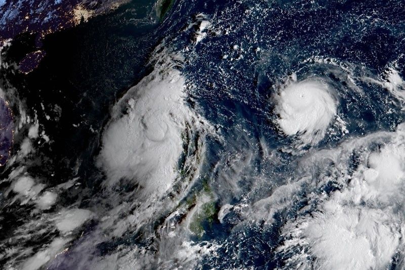
MANILA, Philippines (Updated 8:43 a.m.) — Severe Tropical Storm Jolina is forecast to make its eighth landfall over Lobo-San Juan area in Batangas on Wednesday morning while Typhoon Kiko rapidly intensified over the Philippine Sea.
State weather bureau PAGASA said Jolina has slightly weakened and is about to make another landfall.
At 7 a.m., Jolina was located over the coastal waters of San Juan, Batangas with winds of 95 kph and gusts of up to 115 kph. It is moving west northwest at 15 kph.
Jolina is forecast the Philippine Area of Responsibility on Friday morning.
Tropical cyclone wind signals are still up in the following areas:
Signal No. 2
- Marinduque
- the northern and central portions of Oriental Mindoro (Bansud, Gloria, Pinamalayan, Pola, Socorro, Victoria, Puerto Galera, San Teodoro, Baco, City of Calapan, Naujan)
- the northern and central portions of Occidental Mindoro (Abra de Ilog, Paluan, Mamburao, Santa Cruz, Sablayan) including Lubang Islands,
- the central and southern portions of Quezon (Buenavista, Mulanay, San Narciso, San Francisco, San Andres, Catanauan, General Luna, Lopez, Macalelon, Sampaloc, Unisan, Pagbilao, Sariaya, Alabat, Pitogo, City of Tayabas, Padre Burgos, Lucban, Gumaca, Agdangan, Plaridel, San Antonio, Candelaria, Atimonan, Quezon, Tiaong, Mauban, Perez, Lucena City, Dolores, Real, Infanta)
- Batangas
- Cavite
- Laguna
- Rizal
- Metro Manila
- the southern portion of Bulacan (Pandi, Bulacan, Marilao, Calumpit, Norzagaray, Plaridel, Santa Maria, Balagtas, Bocaue, Bustos, City of Malolos, Angat, Obando, City of San Jose del Monte, Pulilan, City of Meycauayan, Hagonoy, Paombong, Guiguinto, San Rafael, Baliuag)
- Pampanga
- Bataan
- Zambales
- Tarlac
Signal No. 1
- La Union
- the southern portion of Benguet (Sablan, Tublay, Bokod, La Trinidad, Baguio City, Itogon, Tuba, Kapangan, Atok)
- the southern portion of Nueva Vizcaya (Alfonso Castaneda, Dupax del Norte, Dupax del Sur, Aritao, Santa Fe, Kayapa)
- the southern portion of Aurora (Baler, Maria Aurora, San Luis, Dingalan)
- Pangasinan
- Nueva Ecija
- the rest of Bulacan
- the rest of Quezon including Polillo Islands
- Camarines Norte
- the western portion of Camarines Sur (Ragay, Del Gallego, Lupi, Sipocot, Cabusao, Libmanan, Pasacao, Pamplona)
- the western portion of Romblon (Odiongan, Romblon, Banton, Santa Maria, Concepcion, San Andres, San Jose, Looc, Ferrol, Alcantara, San Agustin, Calatrava, Corcuera, Santa Fe)
- the rest of Oriental Mindoro
- the rest of Occidental Mindoro
What to expect
Heavy rainfall
- Heavy to intense with at times torrential rains over: Metro Manila, Romblon, Marinduque, Cavite, Laguna, Batangas, Rizal, Quezon, Camarines Provinces, and Mindoro Provinces
- Moderate to heavy with at times intense rains over: Aurora, Bataan, Bulacan, Nueva Ecija, Pampanga, Tarlac, Zambales, Albay, Sorsogon, northern Palawan, Aklan, Antique, Capiz, Iloilo, and Guimaras
Severe winds
- Damaging gale-force to storm-force winds over: areas under Signal No. 2
- Strong winds (strong breeze to near gale conditions) with occasional gusts over: areas under Signal No. 1
Coastal inundation
- Storm surge of up to 1.5 m over several coastal areas of Quezon
- Rough to very rough seas (2.5 to 5.0 m) over the seaboards of areas under Signal No. 2
- Moderate to rough seas (1.2 to 2.8 m) will be experienced over the seaboards of areas under Signal No. 1
Forecast positions
- Thursday morning: In the vicinity of San Narciso, Zambales
- Friday morning: 470 km west of Daguan City, Pangasinan (outside PAR)
- Saturday morning: 840 km west of Northern Luzon (outside PAR)

Signal No. 4 may be hoisted due to 'Kiko'
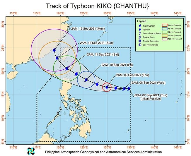
Meanwhile, PAGASA warned that the highest possible wind signal that may be raised for Typhoon Kiko is Signal No. 4.
At 4 a.m., Kiko was located 1,175 km east of Central Luzon with winds of 150 kph and gustiness of 185 kph. It is moving westward at 20 kph.
No tropical cyclone wind signals are raised yet but PAGASA said wind signals may be hoisted for several provinces in Northern Luzon, with higher wind signal levels possible over Extreme Northern Luzon starting Wednesday night or Thursday morning.
Forecast positions
- Thursday morning: 830 km East of Central Luzon
- Friday morning: 410 km East of Aparri, Cagayan
- Saturday morning: Over the coastal waters of Itbayat, Batanes
- Friday morning: 525 km Northwest of Itbayat, Batanes (outside the PAR)
– Patricia Lourdes Viray

Follow this page for updates on Jolina, the tenth tropical cyclone to enter the Philippines on 2021. — Main photo from JTWC
Typhoon Kiko slightly weakens as it moves towards the Babuyan Islands-Batanes area, state weather bureau PAGASA says on Friday morning.
At 4 a.m., Kiko was located 280 km east northeast of Casiguran, Aurora with winds of 185 kph and gustiness of 230 kph.
Tropical cyclone wind signals are raised in the following areas:
Signal No. 3
- the extreme northeastern portion of Cagayan (Santa Ana)
Signal No. 2
- Batanes
- Babuyan Islands
- the remaining eastern portion of mainland Cagayan (Aparri, Camalaniugan, Lal-Lo, Gattaran, Baggao, Peñablanca, Buguey, Santa Teresita, Gonzaga)
- the northeastern portion of Isabela (San Pablo, Maconacon, Divilacan, Palanan)
Signal No. 1
- the rest of mainland Cagayan
- the northeastern portion of Ilocos Norte (Pagudpud, Adams, Dumalneg, Bangui, Vintar, Carasi)
- Apayao
- the eastern portion of Kalinga (City of Tabuk, Pinukpuk, Rizal)
- the northwestern and southeastern portions of Isabela (Santa Maria, Quezon, Mallig, Roxas, San Manuel, Cabatuan, Aurora, City of Cauayan, Angadanan, San Guillermo, Dinapigue, San Mariano, Cabagan, Santo Tomas, Delfin Albano, Tumauini, Quirino, Burgos, Gamu, Ilagan City, Luna, Reina Mercedes, Naguilian, Benito Soliven)
- the northern portion of Aurora (Dilasag, Casiguran)
All tropical cyclone wind signals have been lifted as Tropical Storm Jolina continues to move over the West Philippine Sea, state weather bureau PAGASA says.
The tropical cyclone is forecast to exit the Philippine Area of Responsibility Thursday night.
At 10 a.m., Jolina was located 240 km west of Dagupan City, Pangasinan with winds of 85 kph and gustiness of 115 kph. It is moving west ward at 10 kph.
Severe Tropical Storm Jolina is forecast to exit the Philippine Area of Responsibility by Thursday afternoon or evening, state weather bureau PAGASA says.
At 4 a.m., Jolina was located 145 km west northwest of Iba, Zambales or 175 km west of Dagupan City, Pangasinan with winds of 85 kph and gustiness of 5 kph.
Tropical cyclone wind signal no. 1 is hoisted over:
- the western portion of Pangasinan (Anda, Bolinao, Infanta, Aguilar, Sual, Labrador, Dasol, Bugallon, Burgos, Mabini, Agno, City of Alaminos, Bani, Lingayen, Mangatarem)
- the northern portion of Zambales (San Antonio, Botolan, San Narciso, San Felipe, Cabangan, Palauig, Iba, Masinloc, Candelaria, Santa Cruz)
Severe Tropical Storm Jolina continues to move northwestward crossing the Batangas-Cavite area before emerging over the mouth of Manila Bay on Wednesday afternoon or evening.
State weather bureau PAGASA says Jolina is expected to make its ninth landfall in the vicinity of Bataan Peninsula tonight.
At 2 p.m., Jolina was located in the vicinity of San Nicolas, Batangas with winds of 95 kph and gustiness of 160 kph. It is moving northwestward at 15 kph.
Tropical cyclone wind signals are up in the following areas:
Signal No. 2
- the northern and central portions of Oriental Mindoro (Bansud, Gloria, Pinamalayan, Pola, Socorro, Victoria, Puerto Galera, San Teodoro, Baco, City of Calapan, Naujan)
- the northern and central portions of Occidental Mindoro (Abra de Ilog, Paluan, Mamburao, Santa Cruz, Sablayan) including Lubang Islands
- the central portion of Quezon (Infanta, Real, Mauban, Sampaloc, Lucban, City of Tayabas, Lucena City, Sariaya, Candelaria, Dolores, Tiaong, San Antonio, Pagbilao)
- Batangas
- Cavite
- Laguna
- Rizal
- Metro Manila
- the southern portion of Bulacan (Pandi, Bulacan, Marilao, Calumpit, Norzagaray, Plaridel, Santa Maria, Balagtas, Bocaue, Bustos, City of Malolos, Angat, Obando, City of San Jose del Monte, Pulilan, City of Meycauayan, Hagonoy, Paombong, Guiguinto, San Rafael, Baliuag)
- Pampanga
- Bataan
- Zambales
- Tarlac
Signal No. 1
- Marinduque
- La Union
- the southern portion of Benguet (Sablan, Tublay, Bokod, La Trinidad, Baguio City, Itogon, Tuba, Kapangan, Atok)
- the southern portion of Nueva Vizcaya (Alfonso Castaneda, Dupax del Norte, Dupax del Sur, Aritao, Santa Fe, Kayapa)
- the southern portion of Aurora (Baler, Maria Aurora, San Luis, Dingalan)
- Pangasinan
- Nueva Ecija
- the rest of Bulaca
- the northern and southern portions of Quezon (Padre Burgos, Agdangan, Unisan, Gumaca, Atimonan, Plaridel, Pitogo, Macalelon, Quezon, Alabat, Perez, General Nakar) including Polillo Islands
- the rest of Oriental Mindoro
- the rest of Occidental Mindoro


- Latest
- Trending


