


'Kiko' enters PAR as 'Jolina' weakens further
MANILA, Philippines — State weather bureau PAGASA is now monitoring two severe tropical storms inside the Philippine Area of Responsibility.
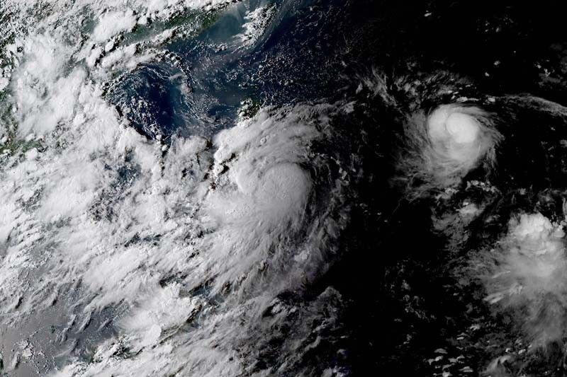
PAGASA announced that Severe Tropical Storm Chanthu has entered the PAR past 5 p.m. and was given the local name “Kiko.” The weather bureau did not provide details such as the cyclone’s location, intensity and movement as bulletins will be issued starting 11 p.m.
However, in an advisory issued at 11 a.m., PAGASA said that Kiko is “unlikely to bring significant amounts of rainfall.” It is also expected to remain far from the Philippine landmass throughout the forecast period.
Weakening continues
Weather forecasters also reported that Severe Tropical Storm Jolina (Conson) has weakened further but it is still expected to dump heavy rains in parts of Luzon and Visayas.
Jolina’s maximum sustained winds decreased from 110 kilometers per hour to 100 kph, and gusts from 135 kph to 125 kph. But it kept its direction and speed, moving west northwest at 15 kph.
It was last seen 60 kilometers west northwest of Masbate City or 90 km east of Romblon town.
Jolina hit the land five times and it is expected to make another landfall or pass near over Marinduque-Southern Quezon area tomorrow morning.
Tropical Cyclone Wind Signals remain hoisted over the following areas:
TCWS No. 2
(Damaging gale force to storm force winds prevailing or expected within 24 hours)
- Central and southern portions of Quezon (Tagkawayan, Guinayangan, Lopez, Buenavista, San Narciso, San Andres, San Francisco, Mulanay, Catanauan, General Luna, Macalelon, Calauag, Gumaca, Pitogo, Unisan, Atimonan, Plaridel, Agdangan, Padre Burgos, Quezon, Alabat, Perez, Mauban, City of Tayabas, Sampaloc, Lucban, Pagbilao, Lucena City, Sariaya, Candelaria, Dolores, Tiaong, San Antonio, Real)
- Southern portion of Rizal (Binangonan, Cardona, Jala-Jala, Pililla)
- Laguna
- Southeastern portion of Batangas (Calaca, Laurel, Lemery, Talisay, San Nicolas, Balete, City of Tanauan, Santo Tomas, Malvar, Lipa City, Mataasnakahoy, Cuenca, Agoncillo, Taal, Santa Teresita, Alitagtag, San Jose, Batangas City, Ibaan, Taysan, Lobo, Rosario, San Juan, Padre Garcia, San Pascual, Bauan, Mabini, San Luis, Tingloy),
- Northeastern portion of Oriental Mindoro (Puerto Galera, San Teodoro, Baco, City of Calapan, Naujan, Victoria, Pola, Socorro, Pinamalayan, Gloria)
- Marinduque
- Romblon
- Sorsogon
- Western portion of Albay (Polangui, Oas, City of Ligao, Guinobatan, Camalig, Daraga, Legazpi City, Manito, Jovellar, Pio Duran, Libon)
- Masbate including Ticao and Burias Islands
- Western and southern portion of Camarines Sur (Bato, Nabua, Balatan, Iriga City, Baao, Bula, Ocampo, Pili, Naga City, Canaman, Pamplona, Milaor, Gainza, Camaligan, San Fernando, Minalabac, Pasacao, Libmanan, Magarao, Cabusao, Bombon, Sipocot, Lupi, Ragay, Del Gallego)
- Western portion of Camarines Norte (Paracale, Jose Panganiban, Capalonga, Santa Elena, Labo, San Vicente, San Lorenzo Ruiz)
TCWS No. 1
(Strong winds prevailing or expected within 36 hours)
- Southern portion of Aurora (Dipaculao, Maria Aurora, Baler, San Luis, Dingalan)
- Southern portion of Quirino (Nagtipunan)
- Southern portion of Nueva Vizcaya (Alfonso Castaneda, Dupax del Sur, Dupax del Norte, Aritao, Santa Fe)
- Nueva Ecija
- Pangasinan
- Tarlac
- Zambales
- Bataan
- Bulacan
- Pampanga
- Metro Manila
- Rest of Rizal
- Rest of Quezon
- Cavite
- Rest of Batangas
- Rest of Oriental Mindoro
- Occidental Mindoro including Lubang Island
- Rest of Camarines Norte
- Rest of Camarines Sur
- Catanduanes,
- Rest of Albay
- Western portion of Northern Samar (Pambujan, San Roque, Silvino Lobos, Mondragon, Lope de Vega, Catarman, Bobon, Victoria, San Jose, Rosario, Lavezares, Allen, Biri, San Isidro, Capul, San Antonio)
- Northwestern portion of Samar (Calbayog City, Santa Margarita, Santo Niño, Almagro, Tagapul-An)
- Biliran
- Northwestern portion of Leyte (San Isidro, Calubian, Leyte, Tabango, Villaba)
- Northern portion of Cebu (Daanbantayan, Medellin, City of Bogo, San Remigio, Santa Fe, Bantayan Islands, Tabogon)
- Northern portion of Negros Occidental (City of Escalante, Sagay City, Cadiz City, Manapla, City of Victorias, Enrique B. Magalona)
- Capiz
- Aklan
- Northern portion of Iloilo (Carles, Balasan, Batad, San Dionisio, Sara, Concepcion, Ajuy, Lemery, Barotac Viejo, San Rafael, City of Passi, Bingawan, San Enrique, Banate, Estancia)
- Northwestern portion of Antique (Caluya)
What to expect
These areas will experience heavy to at times torrential rains in the next 24 hours:
- Masbate
- Sorsogon
- Albay
- Catanduanes
- Camarines Norte
- Camarines Sur
- Southern Quezon
- Romblon
- Marinduque
- Oriental Mindoro
- Occidental Mindoro
Meanwhile, moderate to heavy with at times intense rains will affect residents of the following areas:
- Metro Manila
- Aurora
- Rest of CALABARZON
- Western Visayas
PAGASA warned that the threat of coastal inundation due to storm surge of up to 1 meter remains for several coastal localities in Biliran, Sorsogon, Samar and Masbate, “which may pose threat to life and property.”
Jolina is expected to traverse Calabarzon and Central Luzon before exiting the Philippine landmass and weakening into a tropical storm.


- Latest
- Trending


