


Signal No. 2 still up in 3 Bicol areas as 'Bising' further weakens
April 20, 2021 | 7:44am
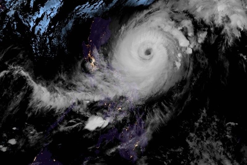
This satellite image shows Typhoon Bising (international name Surigae)
RAMMB
MANILA, Philippines — At least three areas in the Bicol region are still under Tropical Cyclone Wind Signal No. 2 as Typhoon Bising further weakens, state weather bureau PAGASA said.
As of 4 a.m. on Tuesday, Bising was located 505 km east of Infanta, Quezon with maximum winds of 175 kph and gusts of up to 215 kph.
Tropical cyclone wind signals are hoisted over the following areas:
Signal No. 2
Winds of greater than 61 kph and up to 120 kph may be expected in at least 24 hours.
- Catanduanes
- the eastern portion of Camarines Sur (Sagnay, San Jose, Lagonoy, Garchitorena, Presentacion, Caramoan)
- the northeastern portion of Albay (Tiwi, Malinao, Tabaco City, Malilipot, Bacacay, Rapu-Rapu)
Signal No. 1
Winds of 30-60 kph may be expected in at least 36 hours or intermittent rains may be expected within 36 hours
- Batanes
- Cagayan including Babuyan Islands
- Isabela
- Quirino
- Apayao
- the eastern portion of Kalinga (Pinukpuk, Rizal, Tabuk City)
- the extreme eastern portion of Mountain Province (Paracelis)
- the extreme eastern portion of Ifugao (Alfonso Lista)
- the northern portion of Aurora (Baler, Dipaculao, Dinalungan, Casiguran, Dilasag)
- the eastern portion of Quezon (Calauag, Guinayangan, Tagkawayan, Buenavista, San Narciso, San Andres) including Polillo Islands
- Camarines Norte
- the rest of Camarines Sur
- the rest of Albay
- Sorsogon
- the northern portion of Masbate (Aroroy, Masbate City, Baleno, Mobo, Uson, Palanas, Dimasalang) including Burias and Ticao Islands
- Northern Samar
- the northern portion of Samar (Tagapul-An, Almagro, Santo Nino, Calbayog City, Santa Margarita, Gandara, Pagsanghan, Tarangnan, San Jorge, San Jose de Buan, Matuguinao)
- the northern portion of Eastern Samar (Maslog, Can-Avid, Dolores, Oras, San Policarpo, Arteche, Jipapad)
Rainfall forecast
Heavy to intense rains
- Catanduanes
Moderate to heavy rains
- eastern portion of Camarines Sur
- Rapu-Rapu Islands
Sea conditions
Very rough to high seas (4.5 to 10 meters)
- northern and eastern seaboards of Luzon
Rough to high seas (3 to 7 meters)
- northern and eastern seaboards of Eastern Visayas
Rough to very rough seas (2.8 to 4.5 meters)
- northern and western seaboards of Northern Luzon
Rough seas (2.5 to 4 meters)
- eastern seaboards of Caraga and Davao Oriental
- remaining seaboards of areas under TCWS
Moderate to rough seas (1.2 to 3 meters)
- western seaboard of Central Luzon
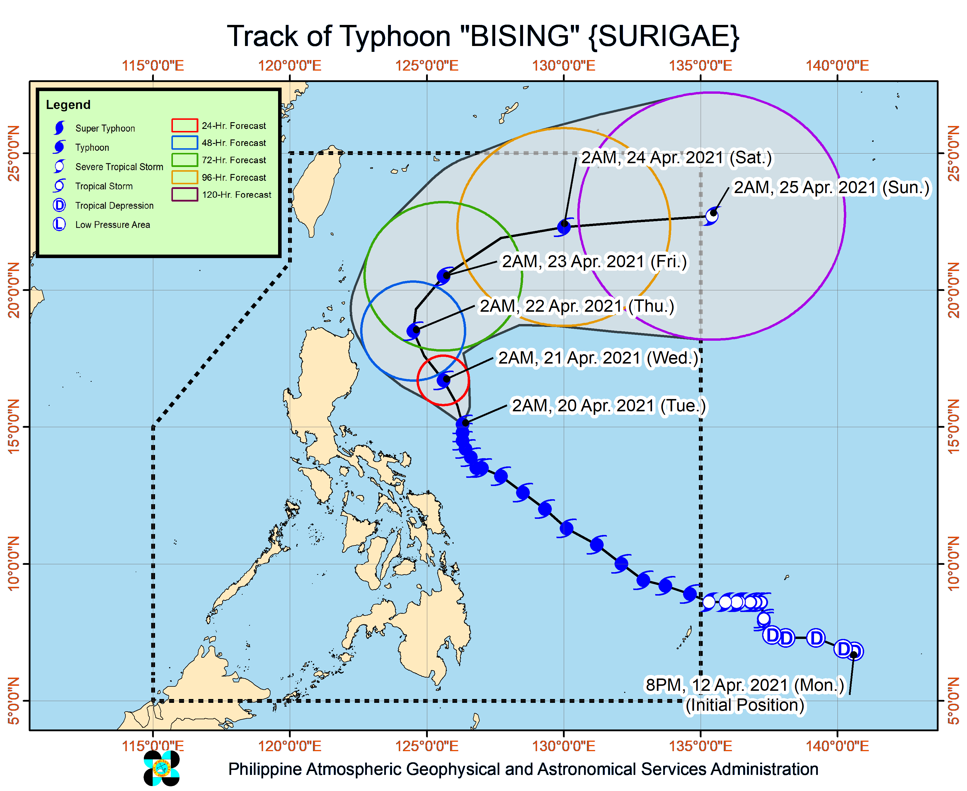
Forecast track
- Wednesday morning: 375 km East of Casiguran, Aurora
- Thursday morning: 305 km East of Aparri, Cagayan
- Friday morning: 380 km East of Basco, Batanes
- Saturday morning: 855 km East Northeast of Extreme Northern Luzon
- Sunday morning: 1,410 km East Northeast of Extreme Northern Luzon (outside PAR)
— Patricia Lourdes Viray
BrandSpace Articles


<
>
Philstar
x
- Latest
- Trending
Trending
Latest
Trending

By Emmanuel Tupas | 16 hours ago

By Ian Laqui | 21 hours ago

By Bella Cariaso | 16 hours ago

By Dapne Galvez | 16 hours ago

Latest


By Alexis Romero | 16 hours ago

16 hours ago

By Patrick Miguel | 16 hours ago

By Mayen Jaymalin | 16 hours ago
Recommended