'Ulysses' maintains strength with expected landfall over Quezon-Aurora
MANILA, Philippines — (Updated 9:55 p.m.) Typhoon Ulysses (international name Vamco) has kept its strength and is set to hit Quezon-Aurora area later tonight, PAGASA said in its latest bulletin.
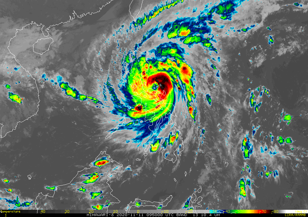
The state weather bureau said Ulysses was closing in at 65 km north of Daet in Camarines Norte, and is still carrying 140 kph maximum sustained winds and 195 kph gusts.
Ulysses, the 21st storm to hit the Philippines this year, is moving at a west southwestward direction at a speed of 15 kph.
At 6:30 p.m. tonight, it was reported to have made a close approach in Calaguas Island, where forecasters have projected that it will make its first landfall.
Now, PAGASA's latest forecast said Ulysses will make landfall in Polillo Islands between 10 p.m. to 12 a.m. of Thursday, as well as over the northern portion of mainland Quezon at dawn.
"Afterwards, Ulysses will cross Central Luzon and emerge over the western seaboard of Zambales tomorrow morning," the agency added.
"Destructive winds and intense with at times torrential rainfall" will are still expected over Camarines Sur and Camarines Norte tonight, and will persist over Aurora and the northern portion of Quezion tonight through early Thursday morning.
Ulysses will bring heavy to intense with at times torrential rains between tonight and early Thursday morning over Camarines Norte, Camarines Sur, Metro Manila, CALABARZON, Aurora, Bulacan, Pampanga and Bataan.
Moderate to heavy with at times intense rains, meanwhile, will be experienced over the Cordillera Administrative Region, mainland Cagayan Valley, Catanduanes, Marinduque as well as the norther portion of Mindoro provinces and the rest of Central Luzon.
The remaining parts of Luzon and Visayas will in turn see light to moderate with ocassional heavy rains.
As of 8 p.m. of November 11, the following areas are still under storm warning signals:
Signal No. 3 (121 to 170 kph winds expected in 18 hours)
- southern portion of Quirino (Maddela, Nagtipunan)
- southern portion of Nueva Vizcaya (Alfonso Castaneda, Dupax Del Norte, Dupax Del Sur)
- Pangasinan
- Nueva Ecija
- Aurora
- Tarlac
- Zambales
- Bataan
- Pampanga
- Bulacan
- Metro Manila
- Rizal
- Cavite
- Laguna,
- northern and central portions of Quezon (General Nakar, Infanta, Real, Mauban, Sampaloc, Lucban, Tayabas City, Sariaya, Candelaria, Dolores, Tiaong, San Antonio, Lucena City, Pagbilao, Atimonan, Padre Burgos, Unisan, Agdangan, Gumaca, Plaridel, Pitogo, Macalelon, Lopez, General Luna, Catanauan, Buenavista, Guinayangan, Tagkawayan, Calauag, Quezon, Alabat, Perez) including Polillo Islands
- Batangas
- Catanduanes
- Camarines Norte
- northern portion of Camarines Sur (Del Gallego, Ragay, Lupi, Sipocot, Cabusao, Bombon, Calabanga, Tinambac, Siruma, Goa, Lagonoy, San Jose, Garchitorena, Presentacion, Caramoan)
Signal No. 2 (61 to 120 kph winds expected in 24 hours)
- rest of Quirino
- rest of Nueva Vizcaya
- southern portion of Benguet (Bokod, Itogon, Tublay, La Trinidad, Sablan, Baguio City, Tuba)
- southern portion of La Union (Burgos, Naguilian, Bauang, Caba, Aringay, Tubao, Pugo, Santo Tomas, Rosario, Agoo)
- rest of Quezon
- Marinduque
- northern portion of Occidental Mindoro (Paluan, Abra de Ilog) including Lubang Island
- northern portion of Oriental Mindoro (Pola, Victoria, Naujan, Baco, Calapan City, San Teodoro, Puerto Galera)
- rest of Camarines Sur
- Albay
- Sorsogon
- Burias
- Ticao Islands
Signal No. 1 (30 to 60 kph winds expected in 36 hours)
- Isabela
- Kalinga
- Mountain Province
- Ifugao
- rest of Benguet
- Abra
- Ilocos Sur
- rest of La Union
- rest of Occidental Mindoro,
- rest of Oriental Mindoro,
- Romblon
- rest of Masbate
- northern Samar
- northern portion of Samar (Santo Nino, Almagro, Tagapul-An, Tarangnan, Calbayog City, Santa Margarita, Gandara, Pagsanghan, San Jorge, San Jose de Buan, Matuguinao),
- northern portion of Eastern Samar (Maslog, Dolores, Oras, San Policarpo, Arteche, Jipapad)
Hazards
PAGASA has said too that there is a "high risk" of a storm surge reaching up to 3 meters in the coastal areas of Aurora, Quezon including Polillo Islands, Camarines Norte, Catanduanes, northern and eastern Camarines Sur.
Storm surge reaching two meters, meanwhile, is also possible over the northern portions of Mindoro provinces including Lubang Island, Marinduque, Romblon, Masbate including Ticao and Burias Islands, as well as Albay, Sorsogon and the remaining areas of Camarines Sur.
"These storm surges, which may be accompanied by swells and/or breaking waves near the coast, can cause life-threatening and damaging coastal inundation," the weather bureau said.
Coastal areas surrounding the Laguna de Bay are also at a moderate risk of a storm surge, forecasters added.
In the next 24 hours, Ulysses will bring rough to very rough seas with wave height reaching between 2.5 to 10 meters over the seaboards of areas under storm warning signals, and the eastern seaboard of Eastern Samar, which are not under Signal No. 1.
The northeast monsoon or Amihan's surge will also bring rough to high seas of about 3 to 6 meters over the remaining seaboards of Northern Luzon and rough seas between 2.5 to 3.5 meters over the seaboards of Kalayaan Islands.
Western seaboards of Palawan, including Calamian Islands, meanwhile, as well as the eastern seaboards of Mindanao, will see moderate to rough seas, with wave height reaching 1.5 to 2.5 meters.
Forecast Positions
- Thursday afternoon: 190 km West of Iba, Zambales
- Friday afternoon: 620 km West of Iba, Zambales (Outside PAR)
- Saturday afternoon: 1,060 km West of Central Luzon (Outside PAR)


- Latest
- Trending