Rains to persist in parts of northern Luzon due to ‘Sarah’
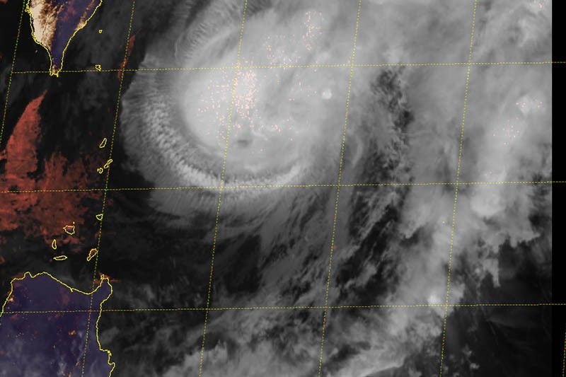
MANILA, Philippines — The trough or extension of Severe Tropical Storm Sarah (Fung-wong) will dump rains over parts of northern Luzon, weather forecasters said late Thursday afternoon.
At 4 p.m., “Sarah” was located 255 kilometers east of Basco, Batanes.
The severe tropical storm now packs maximum sustained winds of 110 kph from the previous 100 kph and gusts of 135 kph from the previous 125 kph. It is forecast to gradually weaken on Friday or Saturday.
Heading northwest at 10 kph, “Sarah” is forecast to exit the Philippine Area of Responsibility on Saturday morning.
Tropical Cyclone Wind Signal No. 1 has been hoisted over Batanes. Intermittent rains or winds between 30 kph and 60 kph may be experienced in the province.
“Sarah” will bring light to moderate rains over Isabela, Cagayan (especially on the eastern section) and northern Aurora.
Meanwhile, gusty conditions will be experienced over the northern and western section of northern Luzon, especially in the coastal and mountainous areas, due to the surge of northeast monsoon or amihan.
Sea travel remains risky over the seaboards of Batanes, seaboards of northern Luzon, and the western seaboard of central and southern Luzon.
Forecast positions
- Friday afternoon: 365 km north northeast of Basco, Batanes
- Saturday afternoon: 755 km north northeast of Basco, Batanes (outside PAR)
- Sunday afternoon: 1,465 km north northeast of Basco, Batanes (outside PAR)
— Gaea Katreena Cabico


- Latest
- Trending