Signal No. 2 in Isabela, Aurora, Quirino as ‘Jenny’ becomes tropical storm
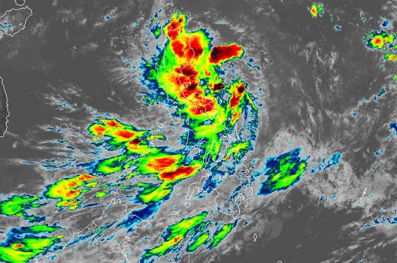
MANILA, Philippines — State weather bureau PAGASA placed three provinces in Luzon under Tropical Cyclone Wind Signal No. 2 as “Jenny” (Podul) intensified into a tropical storm Tuesday morning.
“Jenny” was last spotted 360 kilometers east northeast of Daet, Camarines Norte or 490 km east of Infanta, Quezon.
The tropical storm packs maximum sustained winds of 65 kph near the center and gusts of up to 80 kph. It is moving west northwest—toward Central Luzon—at 25 kph.
Weather forecasters placed Isabela, Aurora and Quirino under TCWS No. 2, which means winds between 61 kph and 120 kph may be expected in at least 24 hours.
TCWS Signal No. 1 is still up over the following areas:
- Cagayan
- Nueva Vizcaya
- Apaya
- Abra
- Kalinga
- Mountain Province
- Ifugao
- Benguet
- Ilocos Norte
- Ilocos Sur
- La Union
- Pangasinan
- Nueva Ecija
- Tarlac
- Zambales
- Bataan
- Pampanga
- Bulacan
- Metro Manila
- Rizal
- Northern portion of Quezon including Polillo Islands
- Cavite
- Laguna
- Camarines Norte
- Northeastern portion of Camarines Sur
- Catanduanes
Winds between 30 and 60 kph or intermittent rains may be expected within 36 hours.
Travel remains risky over the seaboards of areas under TCWS.
“Jenny” is forecast to make landfall in Aurora between Tuesday evening and early Wednesday morning. It is expected to leave the Philippine Area of Responsibility on Thursday.
Rainy weather in most parts of Luzon
PAGASA said that intermittent to frequent moderate to heavy rains will be experienced today over Bicol region, Samar provinces, Quezon, Rizal, Bulacan, Pampanga, Nueva Ecija, Aurora, Nueva Vizcaya, Quirino, Isabela and Cagayan.
Meanwhile, light to moderate with intermittent heavy rains will affect Metro Manila, the rest of Luzon and Visayas, Zamboanga Peninsula, Northern Mindanao and Bangsamoro.
Between Tuesday evening and Wednesday morning, residents of Central Luzon, Metro Manila, Rizal, northern portion of Quezon, Nueva Vizcaya, Quirino, Benguet, Pangasinan and La Union may experience intermittent to frequent moderate to heavy rains. Meanwhile, light to moderate with intermittent heavy rains may affect Western Visayas and the rest of Luzon.
Weather forecasters said that by Wednesday, light to moderate with intermittent to occasional heavy rains may affect Western Visayas, Mindoro provinces, northern portion of Palawan (including Calamian and Cuyo Islands), Zambales and Bataan.
Occasion gusty conditions may also occur in Visayas and other areas of Luzon due to the southwest monsoon.
Forecast positions
- Wednesday morning: 140 km west northwest of Dagupan City
- Thursday morning: 725 km west of Sinait, Ilocos Sur (outside PAR)


- Latest
- Trending