'Ineng' expected to strengthen into tropical storm by Thursday
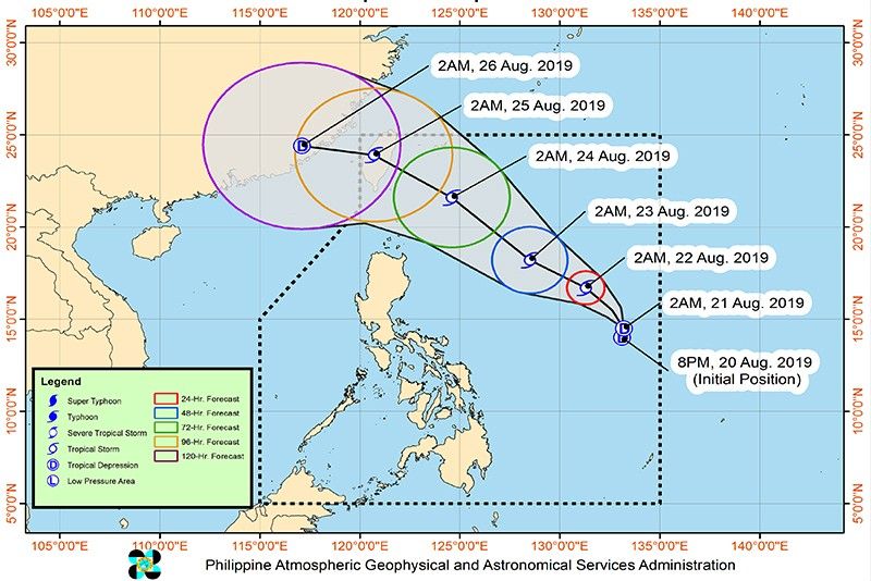
MANILA, Philippines (Update 1 11:40 a.m.) — Tropical Depression Ineng is still on track to develop into a tropical storm by Thursday but is less likely to make landfall, appearing to spare the country as it gathers more strength, PAGASA said in a forecast Wednesday morning.
PAGASA in its 11 a.m. severe weather bulletin added that the tropical depression is expected to leave the Philippine area of responsibility on Sunday, August 25.
"'Ineng' remains less likely to make landfall on any part of the country. Furthermore, this weather disturbance may intensify into a Tropical Storm within 24 hours," the state weather bureau said.
The tropical depression's strength has not changed since PAGASA's first briefing on "Ineng" today at 5 a.m. The weather disturbance still packs maximum sustained winds of 55 kph near the center and gusts of up to 70 kph.
It is slowly moving at a northwest direction and its center is located 1,155 km east of Infanta, Quezon at 10 a.m.
PAGASA said light to moderate with intermittent heavy rains are expected on Wednesday over Bicol and Eastern Visayas due to the outer rain bands of "Ineng."
Similar weather conditions are seen over Mimaropa and the rest of the Visayas, due to the southwest monsoon or habagat, and in Batanes and Babuyan Islands, due to the trough of an LPA near Taiwan.
No Tropical Cyclone Wind Signal is raised.
The Philippines, located on the so-called Pacific Ring of Fire, is visited by around 20 typhoons every year. — with Ian Nicolas Cigaral
Get updates on "Ineng," the ninth tropical cyclone to enter the Philippine area of responsibility in 2019.
Weather bureau PAGASA says "Ineng" has made a landfall over Pingtung Country in southern Taiwan.
Based on its 5 p.m. weather bulletin, the eye of Severe Tropical Storm Ineng was situated at 275 kilometes north northwest of Basco, Batanes.
It continues to move in a west northwest direction at 20 kilometers per hour.
"Tropical Cyclone Wind Signal over Ilocos Norte, Apayao and Cagayan (mainland) are now lifted," PAGASA says.
"Batanes and Babuyan Islands are still warned against strong winds associated with 'INENG'. Furthermore, occasional gusty conditions will still prevail over most of Luzon due to the Southwest Monsoon," it adds.
PAGASA announces that Severe Tropical Storm Ineng is already off the southern coast of Pingtung country in Taiwan.
Based on its 2 p.m. weather bulletin, the center of "Ineng" is located at 185 kilometers northwest of Basco, Batanes.
It has maximum sustained winds of 100 kilometers per hour near the center and gust of up to 125 kph.
"Ineng," which is expected to exit the Philippine area of responsibility on Saturday afternoon, is moving west northwest at 25 kph.
The city government of Laoag, Ilocos Norte has declared a state of calamity after Severe Tropical Storm Ineng and the southwest monsoon brought heavy rains that caused massive flooding in the area.
Severe Tropical Storm Ineng has made a close approach to Batanes as it heads towards southern Taiwan, PAGASA says.
In its 11:00 a.m. weather advisory, the eye of "Ineng" was located at 140 kilometers north northwest of Basco Batanes.
It is moving west northwest at 30 kilometers per hour, with maximum sustained winds of 100 kph near the center and gustiness of up to 125 kph.
"Ineng" is expected to exit the Philippine Area of Responsibility on Saturday afternoon, PAGASA adds.
PAGASA says Severe Tropical Storm Ineng has accelerated further, moving closer to Batanes area.
In its 8 a.m. severe weather bulletin, the center of "Ineng" was located at 105 kilometers north of Basco, Batanes. It is moving west northwest at 30 kilometers per hour, with maximum sustained winds of 100 kph near the center and gustiness of up to 125 kph.


- Latest
- Trending