Typhoon Ulysses makes landfall thrice over Quezon

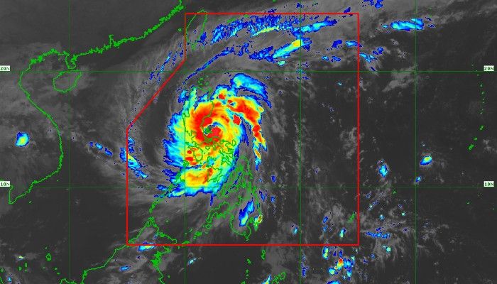
MANILA, Philippines (3rd update; First published at 12:04 a.m.) — Typhoon Ulysses further intensified as it stepped into Quezon, making three landfalls in the area and reaching its peak over the northern part of the province between late Wednesday night and Thursday morning.
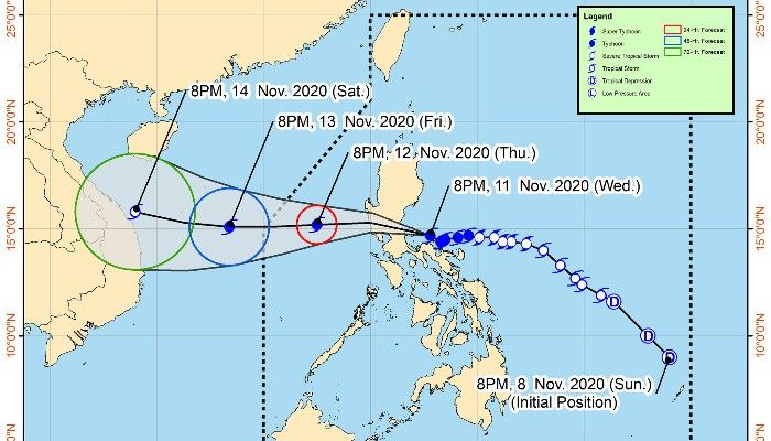
Upon its first landfall at 10:30 p.m. over Patnanungan, Ulysses was packing maximum sustained winds of 150 kilometers per hour near the center and gustiness of up to 205 kph at a slow tracking of 15 kph west-northwestward.
LIVE updates: Typhoon Ulysses
By 11:30 p.m., the cyclone's center was in the vicinity of Burdeos where it made its second landfall. It further strengthened before landing anew over General Nakar in the northern part of the province at 1:30 a.m.
In an earlier advisory, state weather bureau PAGASA forecasted that Ulysses' peak intensity will occur while it made its third landfall.
The cyclone is expected to slightly weaken as it slams against the tips of Sierra Madre and Zambales mountain ranges while remaining a typhoon.
It is then likely to emerge over the western seaboard of Zambales on Thursday morning, according to PAGASA's estimates.
Areas under Signal No. 3
121-170 kph winds prevailing or expected within 18 hours
- Southern portion of Quirino (Maddela, Nagtipunan)
- Southern portion of Nueva Vizcaya (Alfonso Castaneda, Dupax Del Norte, Dupax Del Sur)
- Pangasinan
- Nueva Ecija
Aurora - Tarlac
- Zambales
- Bataan
- Pampanga
- Bulacan
- Metro Manila
- Rizal
- Cavite
- Laguna
- Batangas
- Northern and central portions of Quezon (General Nakar, Infanta, Real, Mauban, Sampaloc, Lucban, Tayabas City, Sariaya, Candelaria, Dolores, Tiaong, San Antonio, Lucena City, Pagbilao, Atimonan, Padre Burgos, Unisan, Agdangan, Gumaca, Plaridel, Pitogo, Macalelon, Lopez, General Luna, Catanauan, Buenavista, Guinayangan, Tagkawayan, Calauag, Quezon, Alabat, Perez) including Polillo Islands
- Camarines Norte
- Northern portion of Camarines Sur (Siruma, Cabusao, Libmanan, Sipocot, Lupi, Ragay, Del Gallego, Tinambac, Calabanga, Bombon, Magarao)

Areas under Signal No. 2
61-120 kph winds prevailing or expected in 24 hours
- Central and southern portions of Isabela (Mallig, Quirino, Ilagan, Roxas, Burgos, Gamu, Palanan, San Mariano, Dinapigue, San Guillermo, Benito Soliven, Naguilian, Reina Mercedes, Luna, San Manuel, Aurora, Cabatuan, Cauayan City, San Mateo, Alicia, Angadanan, Echague, Jones, San Agustin, San Isidro, Ramon, Santiago City, Cordon)
- The rest of Quirino
- The rest of Nueva Vizcaya
- Mountain Province
- Ifugao
- Benguet
- The southern portion of Ilocos Sur (Cervantes, Quirino, San Emilio, Lidlidda, Santiago, Banayoyo, Candon City, Galimuyod, Gregorio Del Pilar, Salcedo, Santa Lucia, Santa Cruz, Sigay, Suyo, Tagudin, Alilem, Sugpon)
- La Union
- Northern portion of Occidental Mindoro (Paluan, Abra de Ilog) including Lubang Island
- Northern portion of Oriental Mindoro (Pola, Victoria, Naujan, Baco, Calapan City, San Teodoro, Puerto Galera)
- Marinduque
- The rest of Quezon
- The rest of Camarines Sur
- Catanduanes
- Albay
- Burias Island
- Northern portion of Sorsogon (Sorsogon City, Castilla, Pilar, Donsol)
Areas under Signal No. 1
30-60 kph winds prevailing or expected in 36 hours
- The rest of Isabela
- Kalinga
- Abra
- The rest of Ilocos Sur
- The rest of Occidental Mindoro
- The rest of Oriental Mindoro
- Romblon
- The rest of Sorsogon
- Central and western portion of Masbate (Palanas, Cawayan, Milagros, Dimasalang, Uson, Mobo, Masbate City, Baleno, Aroroy, Mandaon, Balud) including Ticao Island
- Western portion of Northern Samar (Lavezares, Biri, San Jose, Rosario, Victoria, San Isidro, Allen, San Antonio, Capul, San Vicente)
Ulysses is forecast to step outside the Philippine area of responsibility on Friday morning or afternoon.
- Latest
- Trending


