


Multi-hazard platform empowers Filipinos to report disasters in real-time
MANILA, Philippines — Filipinos can now report and share information about floods, earthquakes, volcanic eruptions, and cyclones in their communities directly from their mobile phones with the launch of a multi-hazard platform.
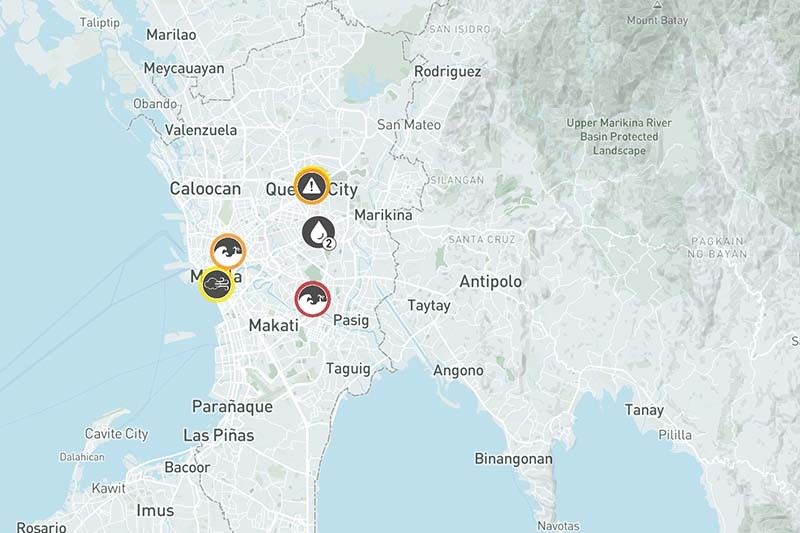
MapaKalamidad.ph is a crowd-based platform that provides real-time hazard information. The tool aims to enhance disaster preparedness and response efforts in the Philippines by empowering citizens to share critical information in the face of hazards.
The Philippines is one of the countries most vulnerable to the impacts of climate change, including cyclones and floods. It is also highly exposed to geologic hazards, such as earthquakes and volcanic eruptions.
MapaKalamidad.ph harnesses the power of social media to gather disaster information from residents on the ground, who often have the most up-to-date information in their area. This real-time information, like a flood report, is then displayed on a web-based map.
The data can be used by authorities to coordinate response efforts.
“MapaKalamidad allows everyone access to this information on their mobile phones, which means every single resident can participate in this cooperative process to share what’s going on around them, to understand what’s going on around them,” Nashin Mahtani, director of Yayasan Peta Bencana (Disaster Map Foundation), told reporters during the platform’s launch Monday.
“That allows people to make critical decisions about safety and navigation during disasters instead of concentrating decision making tools in a small group of people sitting in a control room,” she added.
A pilot version of the platform was launched in 2020, covering only Quezon City and Pampanga. The reach of the tool was expanded nationwide in 2022, but was only limited to flood reports.
“Establishing and developing initiatives in the area of information sharing support the various aspects of our work in disaster risk reduction,” Office of Civil Defense (OCD) Operations Service Director Cesar Idio said.
How to report using the MapaKalamidad.ph
Social media users can search for @kalamidadbot on Telegram or @mapakalamidad on Facebook Messenger to report hazards in their communities.
A one-time link prompts them to input location, upload a photo, and describe the hazard. Then, users will receive links to their reports on the map.
“What makes MapaKalamidad stand out is that it’s not an app, and it plugs into existing social media channels. That’s what allows us to reach millions of users every day,” Mahtani said.
She added the platform was designed to encourage people to submit detailed information, minimizing the risk of false reports.
Government agencies like the OCD and local government units also help validate reports sent by users.
“Through those factors, we’re able to ensure that all of the reports come in real-time, but they’re all verified,” Mahtani said.
The MapaKalamidad.ph team is working on integrating SMS and radio services to allow residents without internet access to report hazards.
The multi-hazard platform has an Indonesian counterpart—PetaBencana.id—which was launched in 2013.


- Latest


