Existing historical evidence from the Iranun reveals West Philippine Sea part of Philippines
MANILA, Philippines — Filipino historian Nasser Sharief revealed the existing historical evidence illustrating the Philippines' jurisdiction over the West Philippine Sea. This was affirmed by 16 sultans who, on behalf of the Iranun, declared ownership over the Spratly Islands and Scarborough Shoal.
"Our noble purpose is to provide the Philippines a timely 'ammunition' on the sovereign claim of the Philippines over the Spratly Islands and the Scarborough Shoal that have never been brought to the argument," Sultan Tomas Reyes Cabili Jr. said.
In Sharief's recently published monograph, "The Iranun and Philippines' Historical Claims in the South China Sea", he found an indigenous Philippine map named "Carta Indigena Filipina" demonstrating the West Philippine Sea, Spratly Islands and Scarborough Shoal as part of the country.
The Iranun, an ethnic group closely related to the Maranao and Maguindanaon, drafted the map that has been housed at the Museo Naval de Madrid since 1847. They are also Filipino ancestors who were expert mariners with significant knowledge of the seascape and islands of Southeast Asia.
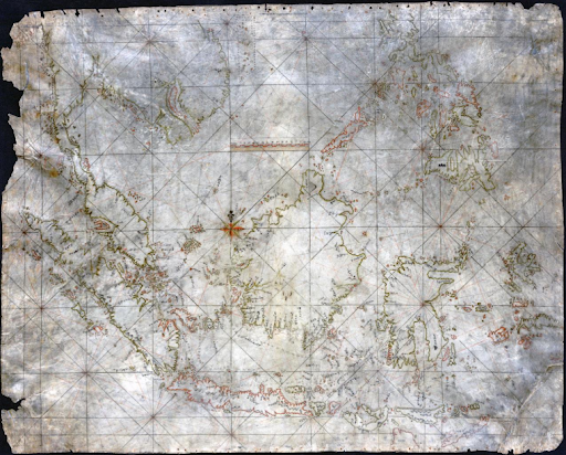
Sharief explained that the Moro-Iranun portulan map was found in a bamboo tube along the waters of the Sulu archipelago and taken from a captured "Moro pirate" ship, hence its name.
Iranun is also a Malay term referring to "pirate," according to the Bangsamoro Commission for the Preservation of Cultural Heritage.
"The provenance of the 'Carta Indigena Filipina' found from the Iranun-Moro 'pirate ship' is pivotal to the Philippines' claim on the Spratlys for the cartography cleanly shows how intimately the Iranun knew minute details of the South China Sea," Sharief said.
However, the historian also recalled the prejudice Southeast Asian countries had toward the Iranun group. Even their contributions to the Philippines' nation-building are not acknowledged, he added.
Some of the forgotten efforts are the Maguindanao cottas the Iranun fought for and Sulu archipelagos they built from the ground up.
"[T]he Iranun are best tuned-out as 'pirates', walk-in characters in the legacy of colonial writings," Sharief said.
But today's territorial standoff between China and the Philippines calls for the Iranun's history and their artifacts. This is an opportunity for the national government to redeem themselves and improve their attitude towards Iranun, Regional chairman Norma Sharief of the Philippine Muslim Teachers' College Institute of Iranun Studies said.
"They are the very key in resolving the impasse at the South China Sea, which now threatens the very security of the world, nay, its very existence," Nasser added.
Since the West Philippine Sea dispute began, China has stood firm in using historical evidence as a reason for their jurisdiction over the body of water and its islands, claiming it to be their "historical right" and disregarding the 2016 Hague ruling of the nine-dash line.
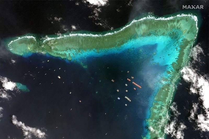
Only last month did the Philippine Coast Guard observed at least 48 Chinese militia vessels in the West Philippine Sea. In April, they found 100 Chinese warships and coast guard ships.
Nasser, however, believes that even the nine-dash line erases off the network established by the Iranun when they traversed along the West Philippine Sea.
"Putting late markers on protruding rocks and planting flags are just semaphore symbolism that has no bearing on actual usage," he said.
If historical evidence bears more weight, he said, then "historical" ownership of disputed islands can be entitled to the Iranun and a Vietnamese indigenous group called Cham.
He added that China's behavior is a clear demonstration of "deliberate ignorance" of Southeast Asian history as they exclude the key islands from the nine-dash line. — Intern, Dominique Nicole Flores


- Latest
- Trending