PAGASA raises Signal No. 1 in Cagayan, Isabela areas due to Super Typhoon Betty
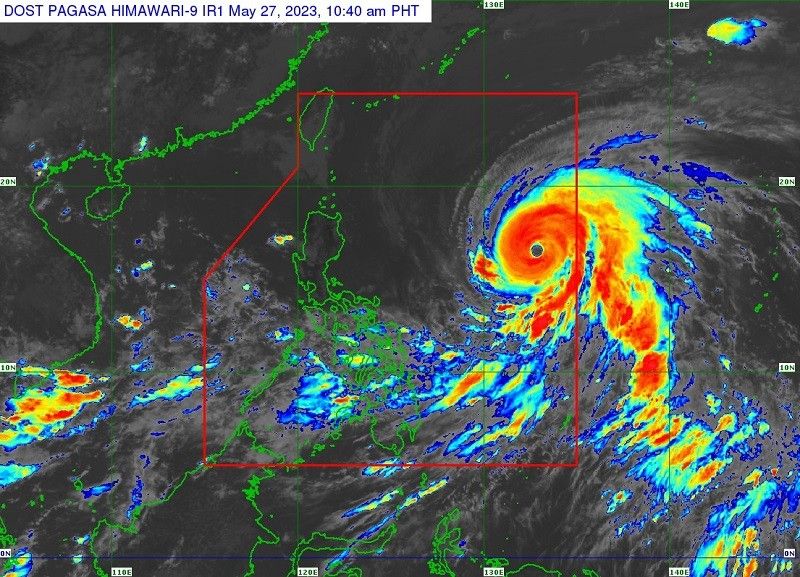
MANILA, Philippines — Super Typhoon Betty maintains its strength while moving west northwestward, prompting the state weather bureau to place the eastern portions of Cagayan and Isabela under Tropical Cyclone Wind Signal No. 1.
The eye of the tropical cyclone was spotted 1,170 kilometers east of Central Luzon at around 10 a.m., according to the latest forecast of PAGASA on Saturday.
- Maximum sustained winds: 195 kilometers per hour near the center
- Gustiness: up to 240 kph
- Movement: west northwestard
- Speed: 30 kph
"Over the weekend, Super Typhoon Betty is forecast to track generally west northwestward. On Monday, the tropical cyclone will turn northwestward and decelerate as it moves over the waters east of Extreme Northern Luzon," said the state weather bureau.
"Betty may eventually become almost stationary between late Tuesday and early Wednesday when it will be closest to Batanes (i.e., within 250-300 km)."
Meanwhile, Tropical Cyclone Warning Signal No. 1 is raised in the following areas:
- The eastern portion of Cagayan (Santa Ana, Gonzaga, Lal-Lo, Gattaran, Baggao, Peñablanca, Santa Teresita, Buguey) including Babuyan and Camiguin Islands
- eastern portion of Isabela (Maconacon, Divilacan, Dinapigue, Palanan, San Mariano, Ilagan City, Tumauini, San Pablo, Cabagan)
Strong winds (strong breeze to near gale strength) will be experienced within the areas where Signal No. 1 is currently hoisted.
"Betty is forecast to remain as a super typhoon over the weekend. Although it will likely maintain its strength for the next 36-48 hours, short-term intensification is not ruled out especially in the next 12 to 24 hours," PAGASA said.
"However, this tropical cyclone may begin weakening considerably on Monday or Tuesday during its slowdown period over the waters east of Batanes due to potential unfavorable conditions (e.g., effect of upwelling of cooler ocean water and dry air intrusion)," it added.
The enhanced southwest moonsoon (habagat) may bring strong breeze to near gale conditions with intermittent gusts starting Sunday evening or early Monday in Visayas, eastern parts of Central and Southern Luzon, and the northern and eastern parts of Mindanao.
Moonsoon rains from the enhanced habagat are possible in the areas that are not directly affected by the super typhoon tomorrow, particularly:
- western sections of MIMAROPA
- Visayas
- Mindanao
Moonsoon rains will likely to be experienced over MIMAROPA and Western Visayas by Monday and Tuesday.
Betty is the second tropical cyclone for 2023 and the first for this month of May.


- Latest
- Trending