


'Odette' slightly weakens, makes another landfall in Palawan
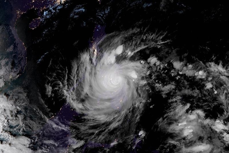
MANILA, Philippines — A slightly weakened Typhoon Odette (international name: Rai) made another landfall over Roxas, Palawan, on Friday afternoon, state weather bureau PAGASA said in its latest bulletin.
Odette, the strongest typhoon to batter the disaster-prone Philippines this year, made landfall over the Palawan municipality at 3:10 p.m. It was last seen at around 4:00 p.m. within the vicinity of San Vicente municipality.
The typhoon slightly weakened with maximum sustained winds of 150 km per hour near the center and gusts of up to 205 kph.
Odette is heading west at 25 kph and is forecast to pass in the vicinity of Kalayaan Islands on Saturday.
The state weather bureau raised Tropical Cyclone Wind Signals over the following areas:
TCWS No. 3 (Destructive typhoon-force winds prevailing or expected within 18 hours)
- Northern portion of Palawan (El Nido, Taytay, Araceli, Dumaran, Roxas, San Vicente, Puerto Princesa City)
“Destructive typhoon-force winds will be experienced within any of the areas where TCWS No. 3 is in effect. This may bring moderate to heavy damage to structures and vegetation,” PAGASA said.
TCWS No. 2 (Damaging gale- to storm-force winds prevailing or expected within 24 hours)
- Central portion of Palawan (Narra, Sofronio Española, Quezon, Aborlan, Rizal, Brooke's Point) including Kalayaan Calamian, Cuyo and Cagayancillo Islands
"Damaging winds reaching gale- to storm-force strength will be experienced within any of the areas where TCWS #2 is in effect," PAGASA said.
"This may result in generally light to moderate damage to structures and vegetation."
TCWS No. 1 (Strong winds prevailing or expected within 36 hours)
- Oriental Mindoro, Occidental Mindoro, and the western portion of Romblon (Santa Maria, Odiongan, Alcantara, Looc, Santa Fe, San Jose, Ferrol, San Andres, San Agustin, Calatrava, Corcuera, Banton, Concepcion), and the rest of Palawan
- Aklan, Capiz, Iloilo, Antique, the western portion of Negros Occidental (Cadiz City, Manapla, City of Victorias, Enrique B. Magalona, Silay City, City of Talisay, Murcia, Bacolod City, Bago City, Valladolid, Pulupandan, La Carlota City, La Castellana, Pontevedra, San Enrique, Moises Padilla, Hinigaran, Isabela, Binalbagan, City of Himamaylan, City of Kabankalan, Ilog, Candoni, Hinoba-An, City of Sipalay, Cauayan, and Guimaras
What to expect
Heavy to torrential rains
- Palawan including Calamian, Cuyo, and Cagayancillo Islands
Moderate to heavy with at times intense rains
- Bicol region
- Quezon
- Rest of MIMAROPA
Light to moderate with at times heavy rains
- Cagayan Valley
- Rest of CALABARZON
- Cordillera Administrative Region
- Aurora
- Lanao del Norte
- Misamis Occidental
According to PAGASA, Odette may exit the Philippine Area of Responsibility Saturday morning or early afternoon.
“Re-intensification is likely once Odette emerges over the West Philippine Sea,” the weather bureau added. "However, continuous weakening may ensue beginning Sunday as the typhoon becomes exposed to increasing vertical wind shear and the surge of the Northeast Monsoon."
More than 300,000 people fled their homes as the typhoon battered the country.
According to the National Disaster Risk Reduction Management Council, one person has been reported dead.
Track
- Saturday morning: 305 km East of Pag-asa Island, Kalayaan, Palawan
- Saturday afternoon: over the coastal waters of Pag-asa Island, Kalayaan, Palawan (outside PAR)
- Sunday morning: 305 km West Northwest of of Pag-asa Island, Kalayaan, Palawan (outside the PAR)
- Sunday afternoon: 500 km Northwest of of Pag-asa Island, Kalayaan, Palawan (outside the PAR)
- Monday morning: 1,080 km West of Central Luzon (outside the PAR)
- Monday afternoon: 1,070 km West of Northern Luzon (outside the PAR)
- Tuesday afternoon: 890 km West of Extreme Northern Luzon (outside the PAR)
- Wednesday afternoon: 715 km West of Calayan, Cagayan (outside the PAR)


- Latest
- Trending


