


'Rai' further intensifies to severe tropical storm as it heads towards PAR
MANILA, Philippines — The tropical storm forecast to enter the Philippine area of responsibility on Tuesday afternoon or evening has further intensified into severe tropical storm category, as government agencies prepare for the impact of the cyclone.
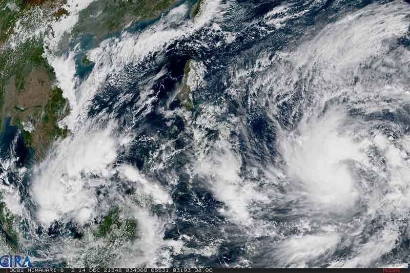
State weather bureau PAGASA in its 11:00 bulletin on Tuesday said Severe Tropical Storm Rai (international name) continues on its west northwestward track to enter PAR on Tuesday afternoon or evening.
The cyclone was located at 1,165 km east of Mindanao, still outside PAR, as of Tuesday 10:00 a.m. It packs maximum sustained winds of 95km/hour near the center and gustiness of up to 115 km/hour.
Once it enters Philippine jurisdiction, it will be assigned the name “Odette.”
Weather forecasters said Rai will start moving westward over the Philippine sea on Wednesday afternoon, and may hit land in Caraga or Eastern Visayas on Thursday afternoon or evening.
PAGASA said while the tropical cyclone is inside PAR, it may further intensify before landfall, and is forecast to reach typhoon category on Wednesday. By Thursday morning or afternoon, it may reach its peak intensity of around 155 km/hour.
Due to strong to typhoon-force winds brought by Rai, the weather bureau said there is high likelihood Visayas, large portions of Mindanao and southern part of Luzon will be placed under Tropical Cyclone Wind Signals
PAGASA said they may hoist up to TCWS No. 3, with localities in eastern portions of Visayas and Mindanao put under Signal No. 1 as early as Tuesday afternoon or evening.
Weather forecasters also said Caraga and Davao Oriental may experience light to moderate with at times heavy rains in the next 24 hours.
“The passage of this tropical cyclone over the central portion of the archipelago may bring heavy to torrential rainfall over Visayas, Mindanao, and several provinces in Southern Luzon, which may bring possible flooding and rain-induced landslides,” the advisory read.
Land travel halted
The Regional Disaster Risk Reduction and Management Council of Eastern Visayas will start implementing the cancellation of land travel for those coming to and from Mindanao and Luzon, effective Tuesday 8:00 a.m., except for those who are already in transit.
“This action is to prevent the unwanted movement, surge, and build-up of individuals and vehicles in ports and terminals due to the cancellation of sea trips due to unfavorable weather conditions,” the RDRRMC 8 letter to transportation regional heads read.
The regional director of the Land Transportation Office also issued a memorandum circular ordering the suspension of land travel bound to Visayas and Mindanao starting 6:00 p.m. of Monday.
Also suspended is land travel bound to Catanduanes and Masbate starting 9:00 a.m. of Tuesday.
The suspension of land travel is directed “as precautionary measure to prevent possible damage to both life and property” due to the typhoon forecast to enter later on Tuesday.
PAGASA also warned of possible coastal inundation due to high waves near the coast and storm surge in low-lying areas near and along the track of the tropical cyclone.
It urged residents of northern and eastern portions of Northern Luzon and the eastern portion of Central Luzon to monitor updates for possible heavy rainfall due to the behavior of the “shear line during and after the passage of the tropical cyclone.”
The passage of Rai will also bring rough to high seas over the seaboards of Mindanao. This is also possible for seaboards of Northern and Central Luzon. The weather bureau added that sea travel is risky for all types of seacrafts over these waters.
For the remaining seaboards in Mindanao, moderate to rough seas are also possible during the passage of the storm, making it risky for sea travel of small seacrafts.
Forecast track, intensity
- Tuesday evening: 945 km east of Mindanao as severe tropical storm
- Wednesday morning: 735 km east of Hinatuan, Surigao del Sur as typhoon
- Wednesday evening: 465 km east of Hinatuan, Surigao del Sur as typhoon
- Thursday morning: 320 km east of Surigao City, Surigao del Norte as typhoon
- Thursday evening: Over the coastal waters of Socorro, Surigao del Norte as typhoon
- Friday morning: Over the coastal waters of Ronda, Cebu as typhoon
- Saturday morning: Over the coastal waters of Taytay, Palawan
- Sunday morning: 165 km northeast of Kalayaan, Palawan


- Latest
- Trending


