PAGASA: Severe Tropical Storm Maring about to exit PAR
MANILA, Philippines — Severe Tropical Storm Maring is set to continue moving westward until it exits the Philippine Area of Responsibility Tuesday morning, government weather forecasters said in the latest update.
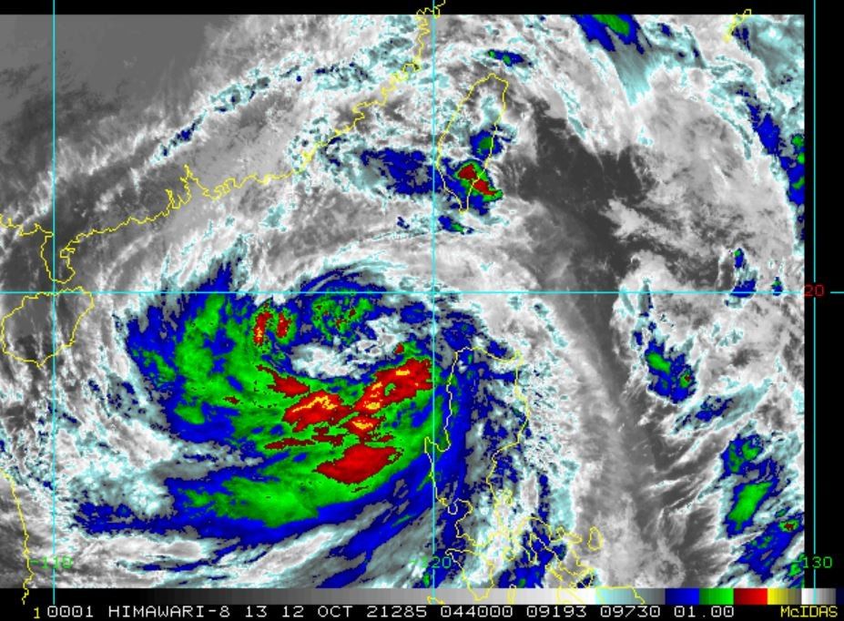
According to the latest weather bulletin issued by state weather bureau PAGASA at 11 p.m. on Tuesday, Maring's center was last seen 315 km west of Calayan, Cagayan and moving westward at 20 kph.
PAGASA added that Maring is carrying maximum sustained winds of 100 kph near the center and gustiness of up to 125 kph, up from 85 and 105 on Sunday. Its tropical cyclone winds also extend outwards up to 850 kilometers from the center.
"It is forecast to exit the Philippine Area of Responsibility this morning," PAGASA said.
"Outside the PAR, 'Maring' will maintain a westward heading and is likely to make landfall in the vicinity of Hainan, China tomorrow evening."

Until then, Tropical Cyclone Wind Signals are still in effect in some areas, particularly in Northern Luzon. They are:
Signal No. 2
- Batanes
- Cagayan including Babuyan Islands
- the northern portion of Isabela (Palanan, Divilacan, Maconacon, Ilagan City, Tumauini, Cabagan, San Pablo, Santa Maria, Santo Tomas, Delfin Albano, Quirino, Gamu, Roxas, Mallig, Quezon)
- Apayao
- Kalinga
- Mountain Province
- Abra
- Ilocos Norte
- and Ilocos Sur
In these areas, PAGASA warned that damaging gale to storm-force winds are prevailing or expected within 24 hours.
Signal No. 1
- The rest of Isabela
- Nueva Vizcaya
- Quirino
- Ifugao
- Benguet
- La Union
- Pangasinan
- Aurora
- Nueva Ecija
- Tarlac
- Zambales
- Pampanga
- Bulacan
- the northern portion of Bataan (Samal, Morong, Dinalupihan, Abucay, Orani, Hermosa)
- and the northern portion of Quezon (General Nakar, Infanta) including Polillo Islands
PAGASA warned that strong winds will be prevailing or are to be expected within 36 hours in these localities.


Follow this page for updates on Maring, the 12th tropical cyclone to enter the Philippines in 2021.
While it has exited the Philippine Area of Responsibility, Severe Tropical Storm Maring will continue to enhance the southwest monsoon, bringing rains over Bataan, Zambales, Occidental Mindoro and Palawan.
At 4 a.m., Maring was located 765 km west of Calayan, Cagayan (outside PAR) with winds of 100 kph and gusts of up to 125 kph.
"The storm will continue moving westward over the West Philippine Sea and maintain its strength until it makes landfall in the vicinity of Hainan, China this afternoon or tonight," state weather bureau PAGASA says.
PAGASA says Severe Tropical Storm Maring is about to exit the Philippine Area of Responsibility.
As of 10 a.m. Tuesday, the center of Maring was estimated based on all available data over 315 kilometers west of Calayan, Cagayan.
It has maximum sustained winds of 100 kilometers per hour near the center, gustiness of up to 125 kph, and central pressure of 975 hPa.
Severe Tropical Storm Maring continues to move away from extreme northern Luzon, state weather bureau PAGASA says.
At 7 a.m., Maring was located 230 km west of Calayan, Cagayan with winds of 100 kph and gusts of 125 kph. It is moving westward at 25 kph.
"Severe Tropical Storm 'MARING' will continue to move westward over the West Philippine Sea throughout the forecast period. It is forecast to exit the Philippine Area of Responsibility (PAR) this morning or afternoon. Outside the PAR, “MARING” will maintain a westward heading and is likely to make landfall in the vicinity of Hainan, China tomorrow evening," PAGASA says in its bulletin.
Severe Tropical Storm Maring slightly intensifies as it moves over the West Philippine Sea.
At 4 a.m., Maring was located 170 km west of Calayan, Cagayan with winds of 100 kph and gustiness of 125 kph.
"Maring" intensifies into a severe tropical storm as it moves towards Babuyan Islands, state weather bureau PAGASA says.
At 10 a.m., Maring was located 240 km east of Aparri, Cagayan or 256 km east sotheast of Calayan, Cagayan with winds of 95 kph and gustiness of 115 kph.
Tropical cyclone wind signals are hoisted over the following areas:
Signal No. 2
- Batanes,
- Cagayan including Babuyan Islands
- the northern portion of Isabela (Palanan, Divilacan, Maconacon, Ilagan City, Tumauini, Cabagan, San Pablo, Santa Maria, Santo Tomas, Delfin Albano, Quirino, Gamu, Roxas, Mallig, Quezon)
- Apayao
- Kalinga
- Mountain Province
- Abra
- Ilocos Norte
- Ilocos Sur
Signal No. 1
- the rest of Isabela
- Nueva Vizcaya
- Quirino
- Ifugao
- Benguet
- La Union
- Pangasinan
- Aurora
- Nueva Ecija
- Tarlac
- Zambales
- Pampanga
- Bulacan
- the northern portion of Bataan (Samal, Morong, Dinalupihan, Abucay, Orani, Hermosa)
- the northern portion of Quezon (General Nakar, Infanta) including Polillo Islands
- Calaguas Islands


- Latest
- Trending