


'Maring' slightly intensifies before exiting PAR
MANILA, Philippines Updated 8:27 a.m.) — Severe Tropical Storm Maring has slightly intensified as it continues to move over the Luzon Strait and West Philippine Sea, state weather bureau PAGASA said.
PAGASA said Maring is forecast to exit the Philippine Area of Responsibility on Tuesday morning or afternoon.
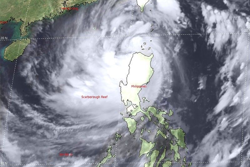
At 7 a.m., the weather disturbance was located 230 km west of Calayan, Cagayan with winds of 100 kph and gusts of up to 125 kph. It is moving westward at 25 kph.
Tropical cyclone wind signals are up in:
Signal No. 2
(Damaging gale to storm-force winds prevailing or expected within 24 hours)
- Batanes
- Cagayan including Babuyan Islands
- the northern portion of Isabela (Palanan, Divilacan, Maconacon, Ilagan City, Tumauini, Cabagan, San Pablo, Santa Maria, Santo Tomas, Delfin Albano, Quirino, Gamu, Roxas, Mallig, Quezon)
- Apayao
- Kalinga
- Mountain Province
- Abra
- Ilocos Norte
- Ilocos Sur
Signal No. 1
(Strong winds prevailing or expected within 36 hours)
- the rest of Isabela
- Nueva Vizcaya
- Quirino
- Ifugao
- Benguet
- La Union
- Pangasinan
- Aurora
- Nueva Ecija
- Tarlac
- Zambales
- Pampanga
- Bulacan
- the northern portion of Bataan (Samal, Morong, Dinalupihan, Abucay, Orani, Hermosa)
- the northern portion of Quezon (General Nakar, Infanta) including Polillo Islands
What to expect
Heavy rainfall
Heavy to torrential rains over:
- Batanes
- the northern portion of Cagayan including Babuyan Islands
- Cordillera Administrative Region
- Ilocos Region
Moderate to heavy with at times intense rains over:
- Zambales
- Bataan
- Tarlac
- the rest of Cagayan
Light to moderate with at times heavy rains over:
- Metro Manila
- Central Luzon
- the rest of Cagayan Valley
Severe winds
- Gale-force to storm-force strength within any of the areas under Signal No. 2
- Strong winds (strong breeze to near gale conditions) with higher gusts within any of the areas under Signal No. 1
- Gusty conditions reaching strong to gale-force in strength over Visayas, Dinagat Islands, Surigao del Norte, Agusan del Norte, Misamis Oriental, Misamis Occidental, Camiguin, Zamboanga del Norte, and the rest of Luzon
Hazards affecting coastal waters
- Rough to high seas (2.8 to 7.5 m) will be experienced over the seaboards of areas under Signals No. 1 and 2
- Moderate to rough seas (1.2 to 2.5 m) will prevail the remaining seaboards of the country
- Gale Warning remains in effect for the western seaboard of Central Luzon (not under any TCWS), the seaboards of Southern Luzon and Visayas, and the western, eastern, and northern seaboards of Mindanao
Forecast position
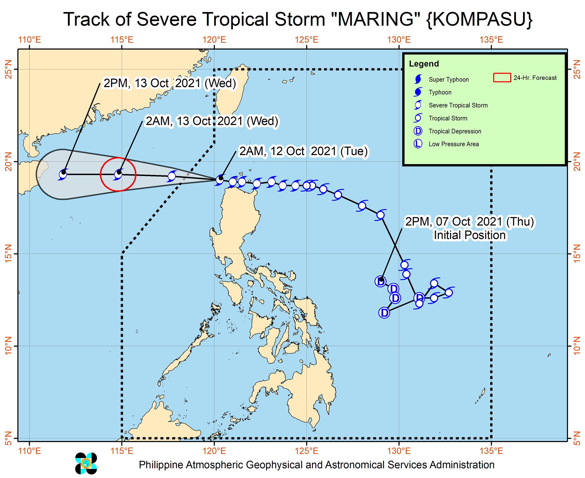
- Tuesday afternoon: 460 km West of Calayan, Cagayan (outside the PAR)
- Wednesday morning: 765 km West of Calayan, Cagayan (outside the PAR)
- Thursday morning: 1,080 km West of Extreme Northern Luzon (outside the PAR)
— Patricia Lourdes Viray
Follow this page for updates on Maring, the 12th tropical cyclone to enter the Philippines in 2021.
While it has exited the Philippine Area of Responsibility, Severe Tropical Storm Maring will continue to enhance the southwest monsoon, bringing rains over Bataan, Zambales, Occidental Mindoro and Palawan.
At 4 a.m., Maring was located 765 km west of Calayan, Cagayan (outside PAR) with winds of 100 kph and gusts of up to 125 kph.
"The storm will continue moving westward over the West Philippine Sea and maintain its strength until it makes landfall in the vicinity of Hainan, China this afternoon or tonight," state weather bureau PAGASA says.
PAGASA says Severe Tropical Storm Maring is about to exit the Philippine Area of Responsibility.
As of 10 a.m. Tuesday, the center of Maring was estimated based on all available data over 315 kilometers west of Calayan, Cagayan.
It has maximum sustained winds of 100 kilometers per hour near the center, gustiness of up to 125 kph, and central pressure of 975 hPa.
Severe Tropical Storm Maring continues to move away from extreme northern Luzon, state weather bureau PAGASA says.
At 7 a.m., Maring was located 230 km west of Calayan, Cagayan with winds of 100 kph and gusts of 125 kph. It is moving westward at 25 kph.
"Severe Tropical Storm 'MARING' will continue to move westward over the West Philippine Sea throughout the forecast period. It is forecast to exit the Philippine Area of Responsibility (PAR) this morning or afternoon. Outside the PAR, “MARING” will maintain a westward heading and is likely to make landfall in the vicinity of Hainan, China tomorrow evening," PAGASA says in its bulletin.
Severe Tropical Storm Maring slightly intensifies as it moves over the West Philippine Sea.
At 4 a.m., Maring was located 170 km west of Calayan, Cagayan with winds of 100 kph and gustiness of 125 kph.
"Maring" intensifies into a severe tropical storm as it moves towards Babuyan Islands, state weather bureau PAGASA says.
At 10 a.m., Maring was located 240 km east of Aparri, Cagayan or 256 km east sotheast of Calayan, Cagayan with winds of 95 kph and gustiness of 115 kph.
Tropical cyclone wind signals are hoisted over the following areas:
Signal No. 2
- Batanes,
- Cagayan including Babuyan Islands
- the northern portion of Isabela (Palanan, Divilacan, Maconacon, Ilagan City, Tumauini, Cabagan, San Pablo, Santa Maria, Santo Tomas, Delfin Albano, Quirino, Gamu, Roxas, Mallig, Quezon)
- Apayao
- Kalinga
- Mountain Province
- Abra
- Ilocos Norte
- Ilocos Sur
Signal No. 1
- the rest of Isabela
- Nueva Vizcaya
- Quirino
- Ifugao
- Benguet
- La Union
- Pangasinan
- Aurora
- Nueva Ecija
- Tarlac
- Zambales
- Pampanga
- Bulacan
- the northern portion of Bataan (Samal, Morong, Dinalupihan, Abucay, Orani, Hermosa)
- the northern portion of Quezon (General Nakar, Infanta) including Polillo Islands
- Calaguas Islands


- Latest
- Trending


