


'Kiko' nears super typhoon status, Signal No. 4 up in Babuyan Islands
MANILA, Philippines — State weather forecasters on Friday afternoon raised Signal No. 4 in the northeastern part of Babuyan Islands as they said Typhoon Kiko is nearing super typhoon status.
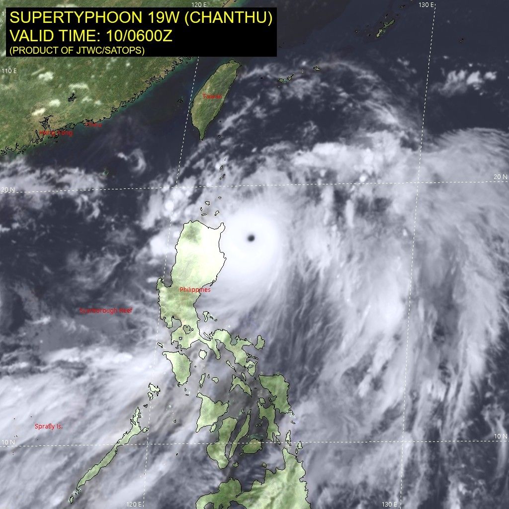
PAGASA said the storm was last seen at 190 km east of Aparri in Cagayan. It is moving northwestward at a speed of 15 kph.
Kiko (Chanthu) further intensified and now carries 215 kilometers per hour peak winds and gusts of up to 265 kph.
The weather bureau classifies a storm as a super typhoon once it reaches winds of 220 kph. The last to hit the Philippines was "Rolly" (Goni) in November last year.
"Further intensification into super typhoon is not ruled out," it said. "Thus, [Signal No. 5] may be the highest wind signal that will be hoisted for this typhoon."
As of 5 p.m. of September 10, these areas are under PAGASA's Tropical Cyclone Wind Signals.
TCWS No. 4
(Very destructive typhoon-force winds prevailing or expected within 12 hours)
- northeastern portion of Babuyan Islands
TCWS No. 3
(Destructive typhoon-force winds prevailing or expected within 18 hours)
- extreme northeastern portion of Cagayan (Santa Ana, Gonzaga)
- rest of Babuyan Islands
- Batanes
TCWS No. 2
(Damaging gale-force to storm-force winds prevailing or expected within 24 hours)
- northern, central, and eastern portions of mainland Cagayan (Aparri, Camalaniugan, Lal-Lo, Gattaran, Baggao, Peñablanca, Buguey, Santa Teresita, Tuguegarao City, Iguig, Amulung, Alcala, Allacapan, Lasam, Ballesteros, Abulug)
- northeastern portion of Isabela (San Pablo, Maconacon, Divilacan, Palanan)
- northeastern portion of Apayao (Flora, Santa Marcela, Luna, Pudtol)
TCWS. No 1
(Strong winds prevailing or expected within 36 hours)
- rest of mainland Cagayan
- eastern portion of Ilocos Norte (Pagudpud, Adams, Dumalneg, Bangui, Vintar, Carasi, Nueva Era,
- Burgos, Pasuquin, Bacarra, Laoag City, Piddig, Solsona, Dingras, Sarrat, San Nicolas)
- rest of Apayao
- northern portion of Kalinga (Balbalan,Pinukpuk, City of Tabuk, Rizal)
- eastern portion of Mountain Province (Paracelis)
- northeastern portion of Abra (Tineg, Lacub, Malibcong)
- northwestern and southeastern portions of Isabela
- (Santa Maria, Quezon, Mallig, Roxas, San Manuel, Cabatuan, Aurora, City of Cauayan, Angadanan, San Guillermo, Dinapigue, San Mariano, Cabagan, Santo Tomas, Delfin Albano, Tumauini, Quirino, Burgos, Gamu, Ilagan City, Luna, Reina Mercedes, Naguilian, Benito Soliven)
- northern portion of Aurora (Dilasag, Casiguran)
What to expect
In the next 24 hours, PAGASA said Kiko is seen to bring heavy to intense with at times torrential rains over the northeastern portion of Cagayan including Babuyan Islands and Batanes.
Northern Isabela and the rest of Cagayan, meanwhile, would see heavy to intense rains. The areas of Ilocos Region, Cordillera Administrative Region, northern and central Aurora and the rest of Cagayan Valley would see moderate to heavy with ocassional intense rains.
The typhoon will keep enhancing the southwest monsoon or the habagat, and bring monsoon rains over the western section of Southern Luzon and Western Visayas also in the next 24 hours.
There is also a "moderate risk" of a storm surge reaching 1 to 2 meters in height in the next 24 hours in coastal areas.
"Rising sea water along with high waves from the shoreline moving inland may cause flooding in low-lying coastal localities of Batanes, Cagayan including Babuyan Islands, and Isabela," PAGASA said.
It added seaboards of areas under wind signals could see rough to phenomenal seas reaching between 3 to 16 meters in height.
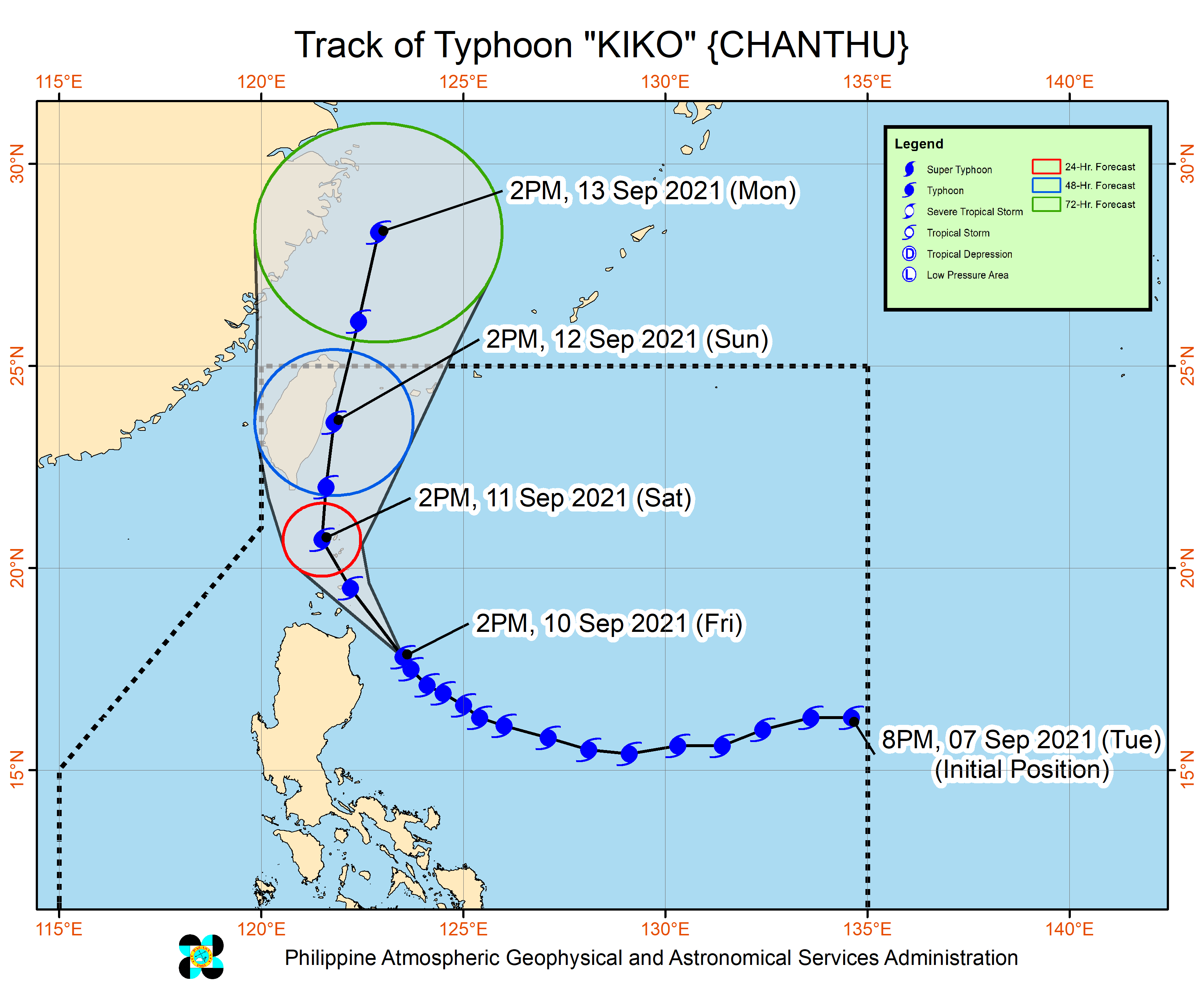
PAGASA is not ruling out a landfall over the northeastern portion of Cagayan. "As such, the public is advised to continue monitoring for possible changes in the track forecast in succeeding bulletins."
Kiko will move northward after passing in the extreme northern Luzon vicinity and is expected to exit the Philippine Area of Responsibility by Sunday evening or Monday morning.
Forecast Position
- Saturday afternoon: Over the coastal waters of Itbayat, Batanes
- Sunday afternoon: 310 km north of Itbayat, Batanes
- Monday afternoon: 595 km north of Itbayat, Batanes (outside PAR)


- Latest
- Trending


