


Typhoon Bising to dump 'moderate to heavy rain' in Bicol region, Eastern Visayas
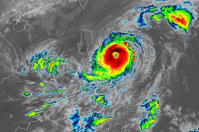
MANILA, Philippines — Typhoon Bising (international name: Surigae) will continue to dump more rain in Bicol region and Eastern Visayas while maintaining its strength, PAGASA said Monday morning.
Bising was last seen 250 kilometers east northeast of Virac, Catanduanes, packing maximum sustained winds of 195 kph near the center and gusts of up to 240 kph.
PAGASA said the typhoon is expected to maintain its current intensity in the next 12 to 24 hours before gradually weakening throughout the remainder of the forecast period.
Bising is projected to move generally northward or north-northwestward until Wednesday evening or Thursday early morning. Then it will head northeastward throughout Thursday an east-northwestward on Friday away from the landmass of Luzon.
Here is PAGASA’s rainfall forecast for Bising:
Moderate to heavy with at times intense rain (Monday)
- Bicol region
- Northern Samar
- Samar
- Eastern Samar
- Biliran
- Leyte
Moderate to heavy rain (Tuesday)
- Bicol region
- Northern Samar
“Under these conditions and considering the antecedent rainfall over the aforementioned areas, flooding (including flashfloods) and rain-induced landslides are increasingly likely to occur especially in areas identified in hazard maps as highly or very susceptible to these hazards,” PAGASA said.
The weather bureau hoisted tropical cyclone wind signals over the following areas:
TCWS No. 2 (Winds between 61 kph and 120 kph may be expected in at least 24 hours)
- Catanduanes
- Eastern portion of Camarines Sur (Garchitorena, Presentacion, Caramoan, Sagnay, San Jose, Lagonoy)
- Eastern portion of Albay (Tiwi, Malinao, Tabaco City, Malilipot, Santo Domingo, Bacacay, Rapu-Rapu, Legazpi City, Manito)
- Eastern and central portions of Sorsogon (Castilla, Sorsogon City, Prieto Diaz, Gubat, Barcelona, Casiguran, Juban, Magallanes, Bulan, Bulusan, Irosin, Santa Magdalena, Matnog)
- Northern Samar
- Samar
- Eastern Samar
- Biliran
TCWS No. 1 (Winds between 30 kph and 60 kph may be expected in at least 36 hours)
- Eastern portion of Isabela (Divilacan, Palanan, Dinapigue)
- Northern portion of Aurora (Casiguran, Dilasag)
- Southeastern portion of Quezon (Guinayangan, Calauag, Tagkawayan) including Polillo Islands, Camarines Norte
- Rest of Camarines Sur
- Rest of Albay
- Rest of Sorsogon
- Masbate including Burias and Ticao Islands
- Leyte
- Southern Leyte
- Northern portion of Cebu (Tabogon, Borbon, San Remigio, Bogo City, Medellin, Daanbantayan) including Bantayan and Camotes Islands
- Dinagat Islands
- Siargao Islands
- Bucas Grande Islands
PAGASA also said the following sea conditions will be experienced over the coastal waters of the country
Very rough to high seas (5 to 12 meters)
- Eastern seaboard of Luzon
Rough to very high seas (2.5 to 7 meters)
- Northern and eastern seaboards of Eastern Visayas
Rough to very rough seas (2.5 to 5 meters)
- Northern and western seaboards of Northern Luzon
- Eastern seaboard of Caraga
Rough seas (2.5 to 4 meters)
- Remaining seaboards of localities where wind signals are in effect
- Eastern seaboard of Davao Oriental
Moderate to rough seas (1.2 to 3 meters)
- Western seaboard of Central Luzon
Forecast positions
- Tuesday morning: 300 km northeast of Virac, Catanduanes or 510 km east of Baler, Aurora
- Wednesday morning: 430 km east of Tuguegarao City, Cagayan
- Thursday morning: 405 km east of Calayan, Cagayan
- Friday morning: 505 km east of Basco, Batanes
- Saturday morning: 965 km east northeast of Basco, Batanes
— Gaea Katreena Cabico
Severe Tropical Storm Bising (international name Surigae) enters the Philippine Area of Responsibility on Friday morning, state weather bureau PAGASA says.
This is the second tropical cyclone to enter the country this year.
TROPICAL CYCLONE UPDATE
— PAGASA-DOST (@dost_pagasa) April 15, 2021
7:00 AM, 16 April 2021
At 6:20 AM today, Severe Tropical Storm "SURIGAE" entered the Philippine Area of Responsibility and was assigned the domestic name "BISING". Severe Weather Bulletins will be issued beginning at 11:00 AM today. pic.twitter.com/m4EJ4bcR5S
PAGASA says Bising weakens into a severe tropical storm.
At 4:00 p.m. Friday, the center of Bising was spotted 825 kilometers east northeast of Basco, Batanes.
Moving northeastward at 15 kilometers per hour, Bising has maximum sustained winds of 110 kph near the center and gustiness of up to 135 kph.
Typhoon Bising slightly weakens as it moves away from the landmass of Luzon, state weather bureau PAGASA says.
At 10 a.m., Bising was located 715 km east northeast of Basco, Batanes or 715 km east northeast of Itbayat, Batanes with winds of 120 kh and gusts of up to 150 kph. It is moving northeastward at 25 kph.
"Tropical cyclone winds of at least strong breeze to near gale in strength extend outward up to 320 km from the center of the typhoon. Destructive typhoon-force winds extend outward up to 50 km from the center of the typhoon," PAGASA says.
Typhoon Bising maintains its strength while moving to the east of Batanes.
State weather bureau PAGASA has lifted Signal No. 1 over Isabela and other areas of Cagayan while the alert is still up in Batanes and the northeastern portion of Cagayan (Santa Ana, Gonzaga) including Babuyan Islands.
At 10 a.m., Bising was located 375 km east northeast of Calayan, Cagayan or 320 km east of Basco, Batanes with winds of 150 kph and gusts of up to 185 kph. It is moving north northwest at 10 kph.
Typhoon Bising weakens as it decelerates over the Philippine Sea, state weather bureau PAGASA says Thursday morning.
The tropical cyclone is forecast to gradually weaken and to be downgraded to severe tropical storm category by Friday.
At 4 a.m., Bising was located 350 km east of Calayan, Cagayan with winds of 150 kph and gusts of 185 kph. It is moving northward at 10 kph.
Tropical cyclone wind signal no. 1 is hoisted over:
- Batanes
- the eastern portion of Cagayan (Santa Ana, Gonzaga, Lal-Lo, Gattaran, Baggao, Peñablanca, Camalaniugan, Buguey, Aparri, Santa Teresita, Alcala, Amulung, Iguig, Tuguegarao City) including Babuyan Islands
- the northeastern portion of Isabela (San Pablo, Maconacon, Divilacan, Palanan)
Seven areas are under Tropical Cyclone Wind Signal no. 1 as Typhoon Bising slows down while maintaining its strength.
At 10 a.m., Bising was located 360 km east of Tuguegarao City, Cagayan with winds of 175 kph and gusts of up to 215 kph. It is moving northwestward at 10 kph.
Areas under Signal No. 1:
- Batanes
- Cagayan including Babuyan Islands
- the eastern portion of Apayao (Luna, Santa Marcela, Flora, Pudtol)
- the eastern portion of Kalinga (Pinukpuk, Rizal)
- the eastern portion of Isabela (Ilagan, San Mariano, Palanan, Divilacan, Maconacon, San Pablo, Cabagan, Tumauini, Santa Maria, Delfin Albano, Santo Tomas, Quezon, Quirino, Gamu, Naguilian, Benito Soliven, Reina Mercedes, Mallig, Burgos, Roxas, Cauayan City, Luna, San Manuel, Cabatuan, Aurora, Dinapigue, San Mateo, Alicia, Angadanan, San Guillermo, Echague, Jones, San Agustin, San Isidro)
- the northeastern portion of Quirino (Maddela)


- Latest
- Trending


