'Ulysses' seen to hit typhoon-battered Southern Luzon, Metro Manila
MANILA, Philippines — Tropical Storm Ulysses—the country's 21st cyclone—is forecast to directly hit or pass near Metro Manila on Thursday, the state weather bureau said.
“Ang prediction natin, with the current data, tatama si Ulysses sa Metro Manila... Maaari din pong hindi tumama ang kanyang mata sa Metro Manila,” PAGASA administrator Vicente Malano said Tuesday as he urged the public to monitor the storm's track.
(With the current data, Ulysses will hit Metro Manila... But it is also possible that its center will not directly pass through Metro Manila.)
Ulysses is forecast to strengthen into a severe tropical storm Tuesday evening. It may reach typhoon category by Wednesday morning and attain its peak intensity of 130 to 155 kph Wednesday afternoon or evening.
When Super Typhoon Rolly (international name: Goni) lashed Luzon early November, it largely bypassed Metro Manila. Before hitting or grazing the capital region, Ulysses is expected to strike the Rolly-battered Bicol region and Calabarzon.
Based on PAGASA’s projection, the center of Ulysses may make landfall over Quezon province Thursday with a close approach over Catanduanes and Camarines Norte—areas badly hit by Super Typhoon Rolly—Wednesday afternoon and evening, respectively.
It is “highly likely” that Ulysses will crash into land at or near peak intensity.
“Tonight until tomorrow would be the most critical period. Ulysses would be near Catanduanes Wednesday afternoon, then in Daet in the evening,” said Landrico Dalida, PAGASA deputy administrator for operations and services.
“Let's not wait for the landfall before we prepare,” Malano added.
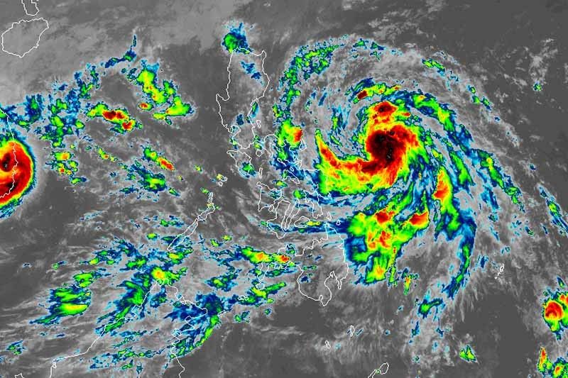
At 10 a.m., Ulysses was located 475 kilometers east of Virac, Catanduanes bearing peak winds of 75 kph near the center from the previous 65 kph and gusts of up to 90 kph from the previous 80 kph. It is heading northwest at 15 kph.
The weather bureau hoisted Tropical Cyclone Wind Signal No. 1 (winds between 30 and 60 kph expected in at least 36 hours) over the following areas in Calabarzon, Bicol region and Eastern Visayas:
- Catanduanes
- Camarines Norte
- Camarines Sur
- Albay
- Sorsogon
- Eastern portion of Masbate (Aroroy, Pio V. Corpuz, Cataingan, Palanas, Uson, Dimasalang, Masbate City, Mobo, Baleno) including Ticao and Burias Islands
- Southern portion of Quezon (Atimonan, Padre Burgos, Agdangan, Unisan, Plaridel, Gumaca, Pitogo, Macalelon, General Luna, Lopez, Catanauan, Mulanay, San Francisco, San Andres, San Narciso, Buenavista, Guinayangan, Tagkawayan, Calauag, Quezon, Alabat, Perez)
- Northern Samar
- Northern portion of Samar (Santo Nino, Almagro, Tagapul-An, Tarangnan, Calbayog City, Santa Margarita, Gandara, Pagsanghan, San Jorge, San Jose de Buan, Matuguinao),
- Northern portion of Eastern Samar (Maslog, Dolores, Oras, San Policarpo, Arteche, Jipapad)
TCWS No. 2 may be raised in some areas of the Bicol region Tuesday afternoon. Based on PAGASA’s projection, the highest wind signal to be hoisted during the passage of Ulysses will be TCWS No. 3.
It will leave the Philippine Area of Responsibility Friday afternoon.
Hazards
The tropical storm will dump light to moderate with at times heavy rains over Aurora, Quezon, Bicol region, Eastern Visayas, Central Visayas, Caraga, Zamboanga Peninsula, Basilan, Sulu, Tawi-Tawi.
Meanwhile, moderate to heavy rains associated with the rainbands of Ulysses will begin affecting Bicol region and portions of Eastern Visayas Wednesday morning.
PAGASA there is a “moderate to high risk” of storm surge of 1 to 2 meters over the coastal areas of the following areas in the next 48 hours:
- Calabarzon
- Aurora
- Camarines provinces
- Catanduanes
- Albay
- Metro Manila
- Bulaca
- Pampanga
- Bataan
- Romblon
- Marinduque
- Western coastal area of Masbate including Burias Island
- Northern coastal areas of Occidental Mindoro and Oriental Mindoro including Lubang Islands
“These storm surges, which may be accompanied by swells and breaking waves reaching the coast can cause life-threatening and damaging coastal inundation,” PAGASA warned.
Ulysses will also bring rough to very rough seas (2 to 5 meters) over the seaboards of areas under TCWS and the eastern seaboard of Eastern Samar, which are not under TCWS, making sea travel risk especially for those with small vessels.
Forecast positions
- Wednesday morning: 285 km east of Daet, Camarines Norte
- Thursday morning: In the vicinity of Cavite City, Cavite
- Friday morning: 455 km west of Subic, Zambales
- Saturday morning: 880 km west of Central Luzon (outside PAR)
— Gaea Katreena Cabico


- Latest
- Trending