'Quinta' intensifies into severe tropical storm
MANILA, Philippines (Updated 12:36 p.m.) — PAGASA on Sunday said Tropical Depression Quinta has intensified as a severe tropical storm as it moves closer to the Catanduanes-Albay-Sorsogon area.
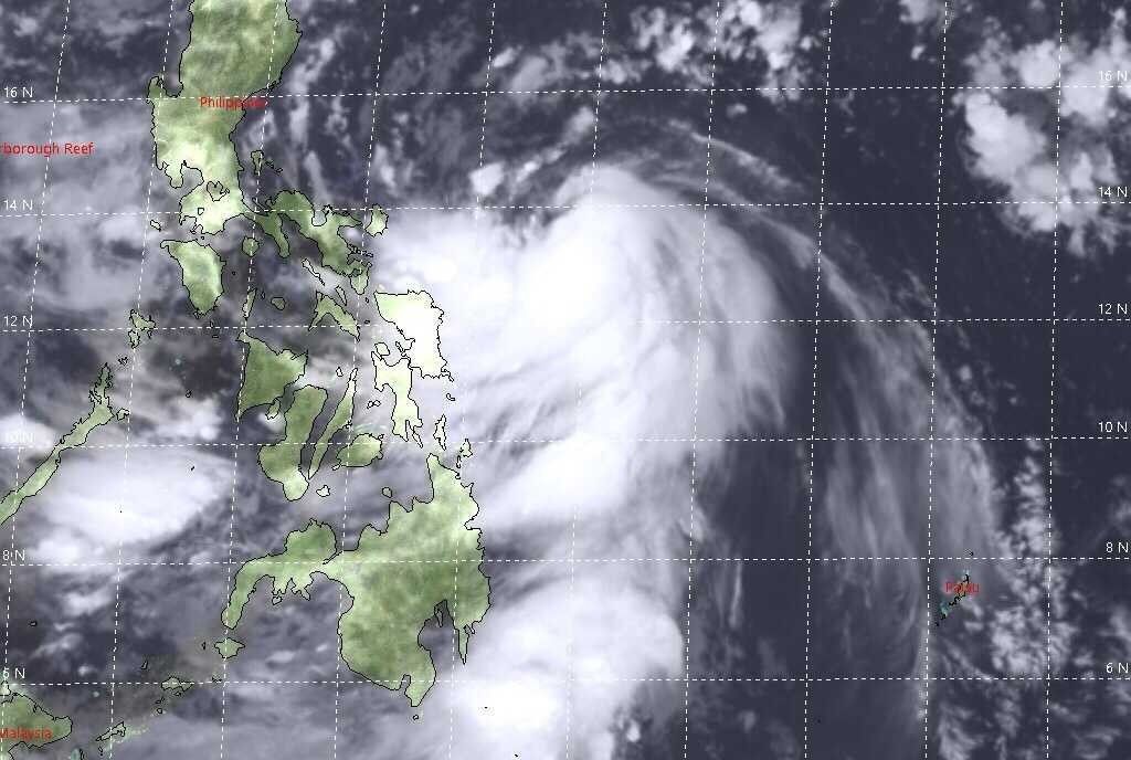
The weather bureau in its latest bulletin said Quinta, the 17th storm to hit the country, was seen at 180 km east of Virac in Catanduanes at 10 a.m. this morning.
Quinta now has a strength of 95 kph maximum sustained winds and gustiness of up to 115 kph as it moves westward at a speed of 25 kph.
PAGASA said it also has a chance to further develop as a typhoon by Tuesday, the same day it is expected to exit the Philippine Area of Responsibility.
From Sunday to Monday morning, Quinta is seen to bring moderate to heavy with occasional intense rains over Bicol Region, CALABARZON, Aurora, Occidental Mindoro, Oriental Mindoro, Romblon, Marinduque, Calamian Islands, Northern Samar, Eastern Samar, Samar, Biliran, Aklan and Antique.
Moderate to heavy with occasional intense rains, meanwhile, will be experienced over Cagayan, Isabela, Apayao and Ilocos Norte due to the tail-end of a frontal system.
"These two weather systems will also bring light to moderate with at times heavy rains over Metro Manila, Cordillera Administrative Region, Zamboanga Peninsula, Bangsamoro, Northern Mindanao, Caraga, and the rest of Visayas, Cagayan Valley, Central Luzon, and MIMAROPA," the agency added.
PAGASA has also warned that a storm surge of 1 to 2 meters may affect the coastal areas of Northern Samar, Bicol Region, as well as the central and southern portions of Quezon.
Disaster officials this morning said some 532 families or 1,789 persons have been preemptively evacuated in the areas of Guinobatan in Albay and Canaman in Camarines Sur.
Some 662 persons, meanwhile, were reported to have been stranded or currently taking shelter.
The following areas are still under Signal No. 2 and 1, with the weather bureau warning that winds at 61 to 120 kph and 30 to 60 kph, respectively, will prevail over the next 24 hours.
Signal No. 2
- Catanduanes
- Camarines Norte
- Camarines Sur
- Albay
- Sorsogon
- northern portion of Masbate (Milagros, Masbate City, Mobo, Baleno, Aroroy, Mandaon, Uson) including Burias and Ticao Islands,
- central and southern portions of Quezon (Mauban, Sampaloc, Lucban, Dolores, Candelaria, Tiaong, San Antonio, Sariaya, Tayabas City, Lucena City, Pagbilao, Atimonan, Perez, Alabat, Calauag, Quezon, Tagkawayan, Guinayangan, Lopez, Pitogo, Plaridel, Gumaca, Unisan, Agdangan, Padre Burgos, Macalelon, Catanauan, General Luna, Buenavista, San Narciso, Mulanay, San Andres, San Francisco)
- eastern portion of Batangas (Padre Garcia, Rosario, Ibaan, Batangas City, Lobo, Taysan, San Juan)
- Marinduque
- Romblon
- Oriental Mindoro
- Northern Samar
Signal No. 1
- rest of Masbate
- rest of Quezon
- Laguna
- Rizal
- rest of Batangas
- Cavite
- Metro Manila
- Bulacan
- Pampanga
- Bataan
- southern portion of Zambales (San Marcelino, San Felipe, San Narciso, Castillejos, Subic, San Antonio, Olongapo City, Botolan, Cabangan)
- Occidental Mindoro
- Calamian Islands
- northern portion of Samar (Calbayog City, Matuguinao, Tagapul-An, Santo Nino, Almagro, Santa Margarita, Gandara, San Jose de Buan, Pagsanghan, Tarangnan, San Jorge, Catbalogan City, Jiabong, Motiong, Paranas)
- northern portion of Eastern Samar (Maslog, Jipapad, Arteche, San Policarpo, Oras, Dolores, Can-Avid, Taft)
- northern portion of Capiz (Sapi-An, Ivisan, Roxas City, Panay)
- Aklan
- northern portion of Antique (Caluya, Libertad, Pandan, Sebaste, Culasi)
- northeastern portion of Iloilo (Batad, Balasan, Estancia, Carles)
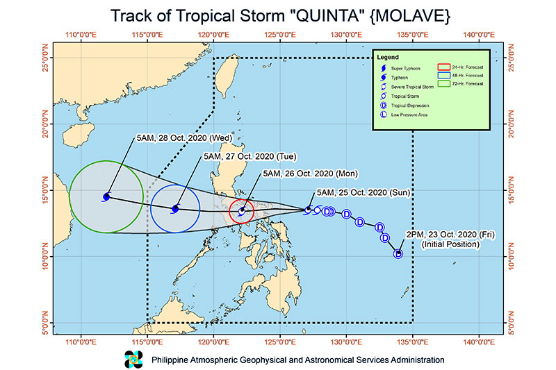
Forecast Positions
- Sunday morning: 30 km East Southeast of Calapan City, Oriental Mindoro
- Tuesday morning: 540 km West of Calapan City, Oriental Mindoro
- Wednesday morning: 960 km West of Central Luzon
— Christian Deiparine

Follow this thread for updates on tropical cyclone Quinta.
Typhoon Quinta is forecast to exit the Philippine Area of Responsibility on Tuesday morning and is seen to intensfy over the West Philippine Sea and reach peak intensity in the next 24 hours, PAGASA says in its early morning bulletin on Tuesday.
The typhoon is expected to bring moderate to heavy rains over Western Visayas, Occidental Mindoro, Palawan including Calamian, Cuyo, and Kalayaan Islands, Aurora, Isabela, Cagayan.
Light to moderate with at times heavy rains over Zamboanga Peninsula, Bangsamoro, Northern Mindanao, Caraga, and the rest of Luzon and Visayas, PAGASA says.
Typhoon Quinta continues to intensify as it moves away from the Philippines, state weather bureau PAGASA says Monday night.
The typhoon is forecast to exit the Philippine Area of Responsibility Tuesday morning and reach its peak intensity within 24 hours.
At 10 p.m., Quinta was located 420 km west of Calapan City, Oriental Mindoro with maximum winds of 140 kph and gusts of 170 kph. It is moving westward at 25 kph.
Signal No. 1 is still hoisted over Lubang Island, Calamian Islands and Kalayaan Islands.
Typhoon Quinta slightly intensifies as it moves towards the western boundary of the West Philippine Sea.
It is forecast to reach its peak intensity in the next 24 hours but would exit the country Wednesday morning, state weather bureau PAGASA says.
At 4 p.m., Quinta was located 310 km west of Calapan City, Oriental Mindoro with maximum sustained winds of 130 kph near the center and gustiness of up to 160 kph.
'Quinta' was 125 kilometers north of Coron, Palawan as of 10 a.m., PAGASA says, or 120 km west southwest of Calapan City, Mindoro.
The typhoon is moving west at 25 km/h and has maximum sustained winds of 125 km/h near the center and gustiness of up to 150 km/h.
Tropical Cyclone Wind Signal No. 3:
Northwestern portion of Occidental Mindoro (Abra de Ilog, Mamburao, Paluan), including Lubang Island
TCWS No. 2 :
Oriental Mindoro
The rest of Occidental Mindoro
Calamian Islands
Batangas
Visayas
Extreme northern portion of Antique (Caluya)
TCWS No. 1:
- Southern portion of Zambales (San Antonio, Castillejos, Subic, Olongapo City)
- Bataan
- Southwestern portion of Pampanga (Floridablanca, Lubao, Sasmuan, Masantol)
- Southwestern portion of Bulacan (Hagonoy, Paombong, Malolos City, Bulacan, Obando, Meycauayan City)
- Metro Manila
- Rizal
- Cavite
- Laguna
- Quezon including Polillo Islands
- Marinduque
- Romblon
- Northern portion of Palawan (El Nido, Taytay), including Cuyo Islands
Visayas
- Aklan and the rest of the northern portion of Antique (Laua-An, Barbaza, Tibiao, Culasi, Sebaste, Pandan, Libertad)
'Quinta' made a fifth landfall over Pola, Oriental Mindoro early Monday morning as it traverses the island and is expected to emerge over the West Philippine Sea.
As of 4 a.m., 'Quinta' was in the vicinity of Socorro, Oriental Mindoro as of 4 a.m., according to an early morning PAGASA bulletin. The typhoon is moving west at 25 kilometers per hour and has maximum sustained winds of 125 km/h near the center and gustiness of up to 180 km/h.
Tropical Cyclone Wind Signal No. 3 is up over the following areas:
- The southern portion of Quezon (Mulanay, San Francisco, Catanauan, General Luna, Macalelon, Pitogo, Unisan, Agdangan, Padre Burgos, Pagbilao, Lucena City, Sariaya, Candelaria, Tiaong, San Antonio, Dolores, Tayabas City)
- Southern portion of Batangas (Lian, Tuy, San Juan, Rosario, Padre Garcia, Lipa City, Cuenca, San Jose, Ibaan, Taysan, Lobo, Batangas City, Mabini, Tingloy, San Pascual, Bauan, Alitagtag, San Luis, Taal, Santa Teresita, Calatagan, Balayan, Calaca, Lemery, Agoncillo, San Nicolas, Mataas Na Kahoy)
- Northern portion of Romblon (Concepcion, Banton, Corcuera, Romblon, San Agustin, Calatrava, San Andres, Odiongan, Santa Maria)
- Marinduque
- Northern and central portion of Oriental Mindoro (Oriental Mindoro (Mansalay, Roxas, Bongabong, Bansud, Gloria, Pinamalayan, Pola, Socorro, Victoria, Naujan, Calapan City, Baco, San Teodoro, Puerto Galera)
- Northern and central portion of Occidental Mindoro (San Jose, Rizal, Calintaan, Sablayan, Santa Cruz, Mamburao, Paluan, Abra de Ilog) including Lubang Island
Tropical Cyclone Wind Signal No. 2 areas:
- Camarines Norte
- Western portion of Camarines Sur (Siruma, Tinambac, Calabanga, Naga City, Pili, Bula, Balatan, Minalabac, Milaor, Bombon, Magarao, Canaman, Camaligan, Gainza, San Fernando, Pasacao, Pamplona, Cabusao, Libmanan, Sipocot, Lupi, Ragay, Del Gallego)
- Burias Island
- Rest of Quezon, including Polillo Islands
- Laguna
- Rest of Batangas
- Cavite, Rizal
- Metro Manila
- Southern portion of Bulacan (Norzagaray, Angat, San Rafael, Baliuag, Pulilan, Calumpit, Hagonoy, Paombong, Malolos City, Plaridel, Bustos, San Jose del Monte City, Santa Maria, Pandi, Guiguinto, Balagtas, Bulacan, Bocaue, Meycauayan City, Obando, Marilao)
- Southern portion of Pampanga (Lubao, Sasmuan, Macabebe, Masantol, Minalin, Apalit), Bataan
- Rest of Romblon
- Rest of Oriental Mindoro
- Rest of Occidental Mindoro, and Calamian Islands
Visayas
- Extreme northern portion of Antique (Caluya)
Tropical Cyclone Wind Signal No. 1 areas:
- Catanduanes
- Rest of Camarines Sur
- Albay
- Western portion of Sorsogon (Donsol, Pilar, Castilla, Sorsogon City, Casiguran, Juban, Magallanes, Bulan, Irosin)
- Northern portion of mainland Masbate (Uson, Mobo, Masbate City, Baleno, Aroroy, Balud, Mandaon, Milagros) including Ticao Island
- Southern portion of Aurora (Dingalan, San Luis)
- Southern portion of Nueva Ecija (Gabaldon, Laur, Palayan City, General Tinio, Cabanatuan City, Aliaga, Zaragoza, Jaen, San Antonio, Santa Rosa, Peñaranda, Gapan City, San Leonardo, San Isidro, Cabiao)
- Southern portion of Tarlac (La Paz, Tarlac City, San Jose, Concepcion, Capas, Bamban)
- Rest of Bulacan
- Rest of Pampanga
- Central and southern portion of Zambales (Iba, Botolan, Cabangan, San Felipe, San Narciso, San Antonio, San Marcelino, Castillejos, Subic, Olongapo City)
- Northern portion of Palawan (El Nido, Taytay) including Cuyo Islands
Visayas
- The rest of the northern portion of Antique (Laua-An, Barbaza, Tibiao, Culasi, Sebaste, Pandan, Libertad)
- Aklan
- Capiz
- Northern portion of Iloilo (Lemery, Sara, San Dionisio, Batad, Estancia, Carles, Balasan)


- Latest
- Trending