Bringing heavy rains and violent winds, Typhoon Tisoy tears through southern Luzon
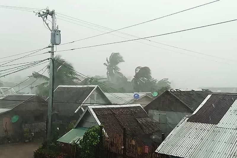
MANILA, Philippines — Typhoon Tisoy (international name: Kammuri) is lashing parts of southern Luzon Tuesday morning, packing ferocious winds along with torrential rains.
Weather forecasters said the typhoon’s eyewall—a powerful part of a tropical cyclone—is now dumping heavy to intense rainfall over southern Quezon, Marinduque and Romblon.
The eyewall is also projected to lash Cavite, Batangas and the northern portion of Mindoro provinces within three hours.
At 7 a.m., the eye of “Tisoy” was spotted over the coastal waters of San Francisco in Quezon Province, packing peak winds of 155 kph and gusts of up to 235 kph. The typhoon earlier weakened after hitting land over Sorsogon province but it was still “powerful,” PAGASA said.
Heading west at 20 kph, “Tisoy” is expected to make another landfall over or pass close to Marinduque-Simara Island-Banton Island area before noon.
The tropical cyclone forced the evacuation of around 58,000 families, cancellation of classes and work and the closure of Ninoy Aquino International Airport as a safety precaution.
Legazpi City Airport also sustained damage during the onslaught of “Tisoy.”
Residents of Bicol region, Romblon, Marinduque, Mindoro provinces, Calabarzon, Metro Manila, Bataan, Pampanga and Bulacan will experience frequent to continuous to intense rains until late Tuesday afternoon.
“Tisoy” will also dump occasional to frequent heavy rains over the rest of Central Luzon and intermittent heavy rains over Samar provinces, Biliran, Aklan, Antique, Capiz, Iloilo, Guimaras, and the northern portions of Negros provinces and Cebu.
Between late Tuesday afternoon and Wednesday morning, frequent to continuous heavy rains (with isolated intense) rains are forecast to affect Mindoro provinces, Metro Manila, Central Luzon, Rizal and northern Quezon, including Polillo Islands.
Meanwhile, occasional heavy rains are expected over Cagayan Valley, Cordillera Administrative Region, Marinduque, Romblon and the rest of Calabarzon, and intermittent heavy rains over Bicol region and Calamian Islands.
Here are the areas udner Tropical Cyclone Warning Signals:
TCWS No. 3 (Winds between 121 kph and 170 kph in at least 18 hours)
- Camarines Sur
- Albay
- Camarines Norte
- Masbate including Ticao and Burias Islands
- Romblon
- Southern portion of Quezon (Perez, Alabat, Quezon, Mauban, Sampaloc, Lucban, Tayabas, Pagbilao, Lucena, Sariaya, Candelaria, Dolores, Tiaong, San Antonio, Atimonan, Padre Burgos, Agdangan, Plaridel, Unisan, Pitogo, Gumaca, Lopez, Macalelon, General Luna, Calauag, Catanauan, Guinayangan, Tagkawayan, Buenavista, Mulanay, San Narciso, San Francsico, San Andres)
- Marinduque
- Oriental Mindoro
- Occidental Mindoro including Lubang Island
- Batangas
- Cavite
- Laguna
TCWS No. 2 (Winds between 61 kph and 120 kph in at least 24 hours)
- Catanduanes
- Sorsogon
- Metro Manila
- Bulacan
- Bataan
- Tarlac
- Pampanga
- Nueva Ecija
- Southern Aurora (Dipaculao, Maria Aurora, Baler, San Luis, Dingalan)
- Rizal
- Rest of Quezon including Polillo Islands
- Calamian Islands (Coron, Busuanga, Culion, Linapacan)
- Cuyo Islands (Cuyo, Magsaysay, Agutaya)
- Zambales
- Pangasinan
- Northern Samar
- Aklan
- Capiz
- Northern Antique (Caluya, Libertad, Pandan, Sebaste, Culasi, Tibiao)
- Northern Iloilo (Carles, Balasan, Estancia, Btad, San Dionisio, Sara, Concepcion, Lemery)
TCWS No. 1 (Winds between 30 and 60 kph in at least 36 hours)
- Southern Isabela (Palanan, Dinapigue, San Mariano, San Guillermo, Benito Soliven, Naguilian, Reina Mercedes, Luna, Aurora, Cabatuan, San Mateo, Cauayan City, Alicia, Angadanan, Ramon, San Isidro, Echague, Cordon, Santiago City, Jones, San Agustin)
- Mountain Province
- Ifugao
- Benguet
- Nueva Vizcaya
- Ilocos Sur
- La Union
- Quirino
- Rest of Aurora
- Northern portion of Palawan (El Nido, Taytay, Araceli, Dumaran)
- Eastern Samar
- Samar
- Biliran
- Northern Negros Oriental (Canlaon, Guihulngan, Vallerhermoso)
- Northern Negros Occidental (Talisay, Calatrava, Silay, Enrique B. Magalona, Victorias, Manapla, Cadiz, Sagay, Escalante, Toboso, Bacolod, Murcia, Salvador Benedicto, San Carlos, Bago, Pulupandan, Valladolid, La Carlota, San Enrique, Pontevedra, La Castellana, Moises Padilla)
- Northern Cebu (Daanbntayan, Bantayan, Madridejos, Santa Fe, Medellin, Bogo City, San Remigio, Tabogon, Tabuelan, Tuburan, Carmen Borbon, Sogod, Catmon, Asturias and Camotes Islands)
- Rest of Antique
- Rest of Iloilo
- Guimaras
- Leyte
PAGASA has lifted storm signals over Bohol, Siquijor, Southern Leyte, and the rest of Cebu, Negros Occidental and Negros Oriental.
The state weather bureau also warned that storm surges with a height between two to three meters are possible in the coastal areas of:
- Batangas
- Mindoro provinces
- Marinduque
- Romblon
- Ticao and Burias Islands
- Southern coast of southern Quezon
Meanwhile, there could also be storm surges with a height between one to two meters over:
- Camarines Norte
- Northern coast of Southern Quezon
- Cavite
- Metro Manila
- Bulacan
- Pampanga
- Bataan
- Zambales (Subic Bay coastal areas)
Sea travel remains risky over the seaboards of areas under TCWS, seaboards of northern Luzon, western seaboard of Palawan, and northern and eastern seaboards of Mindanao.
Forecast positions
- Wednesday morning: 210 km west southwest of Subic, Zambales
- Thursday morning: 595 km west of Subic, Zambales (outside PAR)
- Friday morning 721 km west of Coron, Palawan (outside PAR)


- Latest
- Trending