‘Tisoy’ lashes Northern Samar with torrential rains, fierce winds ahead of landfall
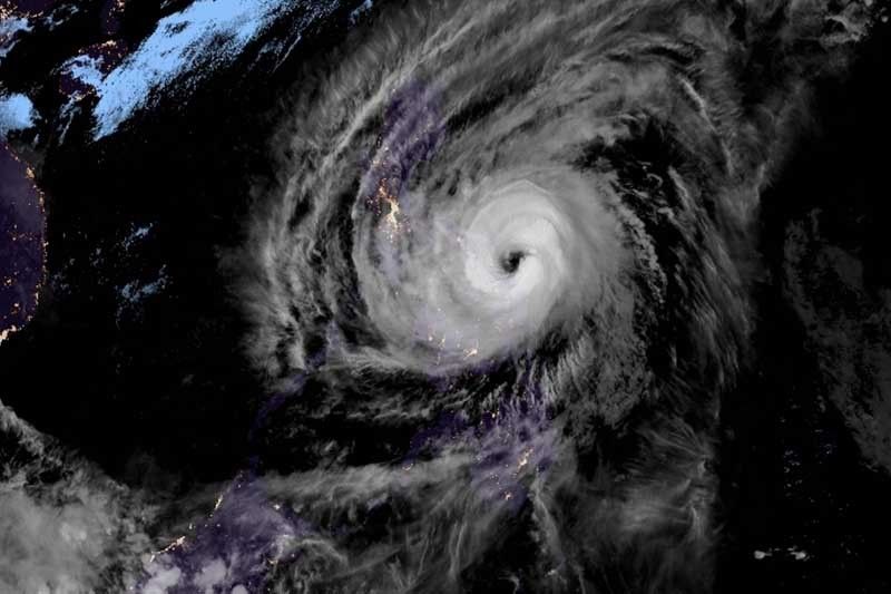
MANILA, Philippines — Hours before its expected landfall, Typhoon Tisoy (Kammuri) is already dumping intense rains and unleashing violent winds over Northern Samar.
In a bulletin issued late Monday afternoon, PAGASA said the southern eyewall—a powerful part of a tropical cyclone—of “Tisoy” is already hitting the Eastern Visayas province.
The typhoon’s eyewall is also expected to strike Sorsogon, Albay, Catanduanes and Camarines Sur in the next three hours.
At 4 p.m., “Tisoy” was located 115 km east of Juban, Sorsogon.
Heading west at a slower pace of 15 kph, the typhoon is projected to make landfall over Albay-Sorsogon area between Monday night and early Tuesday morning.
The typhoon now packs peak winds of 155 kph from the previous 150 kph and gusts of up to 190 kph from the previous 185 kph.
PAGASA has placed most of Luzon and Visayas under Tropical Cyclone Wind Signals. Here are the areas under TCWS:
TCWS No. 3 (Winds between 121 kph and 170 kph in at least 18 hours)
- Catanduanes
- Camarines Sur
- Albay
- Sorsogon
- Camarines Norte
- Masbate including Ticao and Burias Islands
- Romblon
- Southern portion of Quezon (Perez, Alabat, Quezon, Atimonan, Padre Burgos, Agdangan, Plaridel, Unisan, Pitogo, Lopez, Macalelon, General Luna, Calauag, Guinayangan, Tagkawayan, Buenavista, Mulanay, San Narciso, San Francsico, San Andres)
- Marinduque
- Northern Samar
- Northern portion of Eastern Samar (Can-avid, Dolores, Maslog, Oras, Arteche, Jipapad, San Policarpio)
- Northern portion of Samar (Catbalogan, Jiabong, Motiong, Paranas, San Jose de Buan, San Jorge, Pagsanghan, Tarangnan, Sta. Margarita, Gandara, Matuguinao, Calbayog, Tagapul-an, Almagro, Sto. Niño
TCWS No. 2 (Winds between 61 kph and 120 kph in at least 24 hours)
- Metro Manila
- Bulacan
- Bataan
- Tarlac
- Pampanga
- Nueva Ecija
- Southern Aurora (Dipaculao, Maria Aurora, Baler, San Luis, Dingalan)
- Cavite
- Batangas
- Laguna
- Rizal
- Rest of Quezon including Polillo Islands
- Oriental Mindoro
- Occidental Mindoro
- Calamian Islands
- Zambales
- Rest of Eastern Samar
- Rest of Samar
- Biliran
- Aklan
- Capiz
- Antique
- Iloilo
- Northern portion of Negros Occidental (Talisay, Calatrava, Silay, Enrique B. Magalona, Victorias, Manapla, Cadiz, Sagay, Escalante, Toboso)
- Northern Cebu (Daanbantayan, Bantayan, Madridejos, Santa Fe, Medellin, Bogo City, San Remigio, Tabogon, Tabuelan, Tuburan, Carmen Borbon, Sogod, Catmon, Asturias and Camotes Island)
- Northern portion of Leyte (Baybay, Mahaplag, Abuyog, Javier, Macarthur, Mayorga, La Paz, Dulag, Albuera, Baraurn, Julita, Tolosa, Tanauan, Tabontabon, Dagami, Pastrana, Palo, Sta. Fe, Tacloban, Alangalang, Jaro, Babatngon, San Miguel, Barugo, Tunga, Carigara, Capoocan, Calubian, San Isidro, Tabango, Villaba, Kananga, Matag-ob, Palompon, Isabel, Merida and Ormoc)
- Guimaras
TCWS No. 1 (Winds between 30 to 60 kph in at least 36 hours)
- Southern Isabela (Palanan, Dinapigue, San Mariano, San Guillermo, Benito Soliven, Naguilian, Reina Mercedes, Luna, Aurora, Cabatuan, San Mateo, Cauayan City, Alicia, Angadanan, Ramon, San Isidro, Echague, Cordon, Santiago City, Jones, San Agustin)
- Mountain Province
- Ifugao
- Benguet
- Nueva Vizcaya
- Ilocos Sur
- La Union
- Pangasinan
- Quirino
- Rest of Aurora
- Rest of Negros Occidental
- Metro Cebu (Balamban, Toledo City, Pinamungahan, Aloguinsan, Naga City, Talisay City, Cordova, Minglanilla, Lapu-Lapu City, Mandaue City, Cebu City, Consolacion, Liloan, Compostela and Danao City)
- Rest of Leyte
- Southern Leyte
- Dinagat Islands
- Siargao Island
Bicol’s level of disaster preparedness, vulnerability
“Tisoy” is forecast to crash into land in Albay-Sorsogon area—a region often impacted by tropical cyclones—several hours from now.
According to a 2018 report of the Harvard Initiative Program on Resilient Communities, Bicol placed as the fifth most disaster resilient region in the Philippines.
It was cited in the report as the region with second highest level of disaster preparedness. The region also had highest levels of disaster preparedness specifically to an early warning and third highest levels of advanced discussion on disaster preparedness.
The report also found that more residents in Bicol region had health or medical insurance. Few, however, had life, home or asset insurance to cover losses caused by disasters.
At least 3,008 individuals in Bicol region and Eastern Visayas have already fled their homes.
“Tisoy” also forced local government units to cancel classes and work.
Heavy to intense rains
Residents of Bicol region, Northern Samar, southern Quezon, Marinduque and Romblon will experience frequent to continuous heavy to intense rains between Monday evening and Tuesday morning.
“Tisoy” will also dump frequent to continuous heavy rains over Samar, Eastern Samar, Rizal, rest of Quezon, Laguna and Oriental Mindoro, and moderate to intermittent heavy rains over Metro Manila, Occidental Mindoro, rest of CALABARZON, Cagayan, Isabela, Aurora and the rest of Eastern Visayas.
Frequent to continuous heavy to intense rains are projected to affect CALABARZON, Central Luzon, Mindoro provinces, Marinduque and Romblon between Tuesday morning and evening as the typhoon passes through southern Luzon.
Meanwhile, occasional to frequent heavy rains will be experienced over Cagayan Valley, Cordillera Administrative Region and Calamian Islands, and intermittent heavy rains over Aklan, Capiz and northern Antique.
There could be storm surge with height of more than 3 meters over several coastal areas in Catanduanes, Camarines Norte and Camarines Sur.
Those living in the coastal areas of Batangas, Quezon, Albay and Marinduque may also experience storm surge with height of up to 3 meters.
Sea travel remains risky over:
- Seaboards of areas under TCWS
- Seaboards of northern Luzon
- Western seaboard of Palawan
- Central seaboard of Visayas
- Northern and eastern seaboards of Mindanao
Forecast positions
- Tuesday afternoon: In the vicinity of Naujan, Oriental Mindoro
- Wednesday afternoon: 345 km west of Subic, Zambales
- Thursday afternoon: 615 km west of Subic, Zambales (outside PAR)
- Friday afternoon: 680 km west of Coron, Palawan (outside PAR)
— Gaea Katreena Cabico


- Latest
- Trending