Batanes, Babuyan still under Signal No. 1 as ‘Hanna’ continues to intensify
MANILA, Philippines — Light to moderate with at times heavy rains and gusty winds will prevail over Batanes and Babuyan Group of Islands until Thursday due to the effects of Typhoon Hanna (international name: Lekima), state weather forecasters said.
In a 5 p.m. bulletin, state weather bureau PAGASA said Tropical Cyclone Wind Signal Number 1 remains hoisted over Batanes and Babuyan Group of Island. Winds between 30 to 60 kilometers per hour or intermittent rains may be expected in these areas within 36 hours.
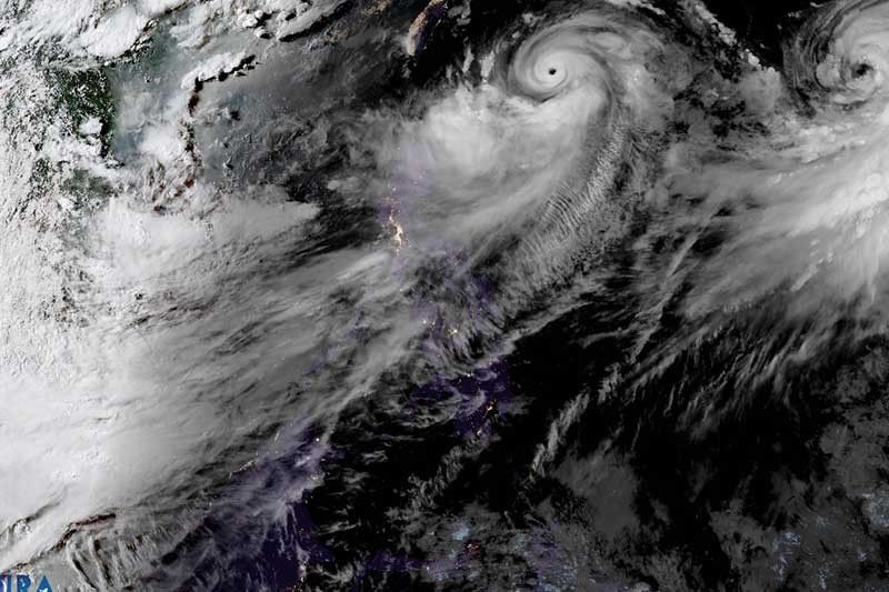
“Hanna” was last seen 590 km east of Basco, Batanes with maximum sustained winds of 140 kph from the previous 130 kph. Its gusts also intensified to 170 kph from the previous 160 kph.
PAGASA said it would continue to strengthen as it heads toward the southern Ryukyu Islands in Japan but no landfall on any part of the Philippines is expected.
The slow-moving typhoon has picked up speed, now moving north-northwest at 15 kph. “Hanna” will leave the Philippine area of responsibility on Friday.
Residents of the northern portions of Palawan—including Calamian and Cuyo islands—Occidental Mindoro, Oriental Mindoro, Romblon, Zambales, Bataan, Aklan, Antique, Iloilo and Guimaras will experience moderate to heavy monsoon rains tonight.
Meanwhile, those living in Metro Manila and the rest of Luzon and Western Visayas will be affected by light to moderate with at times heavy rains.
By Thursday, moderate to heavy monsoon rains may prevail over Metro Manila, Ilocos, Cordillera Administrative Region, Zambales, Bataan, Rizal, Cavite, Laguna, Batangas, Mindoro provinces and the northern parts of Palawan.
Light to moderate with at times heavy rains may affect those in Western Visayas and the rest of Luzon.
The enhanced southwest monsoon will also trigger occasional gusty conditions over the western sections of Luzon and Visayas.
PAGASA also warned against sea travel on the seaboards of Batanes and Babuyan Group of Islands, seaboards of Luzon and Visayas, and the northern and eastern seaboards of Mindanao.
Weather forecasters are also monitoring two weather systems: a severe tropical storm outside PAR and a low pressure area off the waters of Pangasinan.
The LPA, which was last seen 325 km west of Dagupan City, Pangasinan, remains less likely to develop into a tropical depression.
Meanwhile, Severe Tropical Storm Krosa was spotted 2,010 km east of extreme Northern Luzon with maximum sustained winds of 95 kph near the center and gusts of up to 115 kph. It is not expected to enter the country’s jurisdiction.
Forecast positions
- Thursday afternoon: 455 km northeast of Basco, Batanes
- Friday afternoon: 545 km north of Basco, Batanes (outside PAR)
- Saturday afternoon: 805 km north of Basco, Batanes (outside PAR)
- Sunday afternoon: 1,110 km north of Basco, Batanes (outside PAR)
— Gaea Katreena Cabico


- Latest
- Trending