‘Rosita’ to make landfall over Cagayan-Isabela area Tuesday; storm signals up Sunday
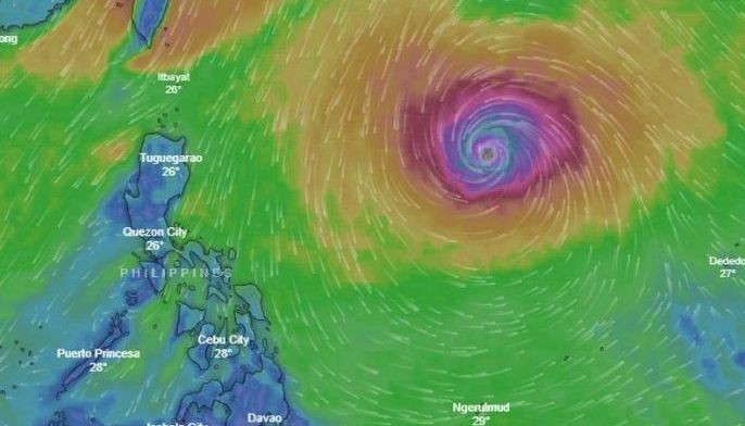
MANILA, Philippines — Typhoon Rosita (international name: Yutu) entered the Philippine area of responsibility Saturday morning. The storm is expected to make landfall over the area of Cagayan and Isabela on Tuesday.
In an 11 a.m. advisory, the state weather bureau said the eye of Rosita was spotted 1,345 km east of Aparri, Cagayan at 10 a.m.
Starting Monday evening, northern and central Luzon will experience moderate to heavy rains due to the typhoon, which will bring very strong winds in these parts of the country on Tuesday morning.
The storm is moving west at a speed of 20 kilometers per hour. It is packing maximum sustained winds of 200 kph near the center and gustiness of up to 245 kph.
The eastern section of northern and central Luzon might be placed under tropical cyclone warning signals on Sunday evening, government meteorologists said. The lowest storm alert could be raised over Metro Manila on Monday night.
There is a slim chance that Rosita, the 18th tropical cyclone to enter the country this year, will gain more strength due to cold winds brought by the northeast monsoon, or “amihan.” Heated air due to warming sea water fuels typhoons and hurricanes.
“Flooding and landslides are possible. Travel by land and sea is risky,” Philippine authorities said.
According to state weather forecasters, Rosita has similarities to monster typhoon "Ompong" (international name: Mangkhut) in terms of diameter and track.
Ompong — which had maximum sustained winds of 205 kph and gusts as strong as 255 kph — sliced across northern Luzon last month, killing dozens of people and destroying infrastructure as well as vast swathes of farmlands.
Rosita, considered a super typhoon in the United States, battered houses and cars in the Northern Marianas Islands, where at least one person has been reported dead. It is believed to be the strongest storm to hit any part of the US in 2018.
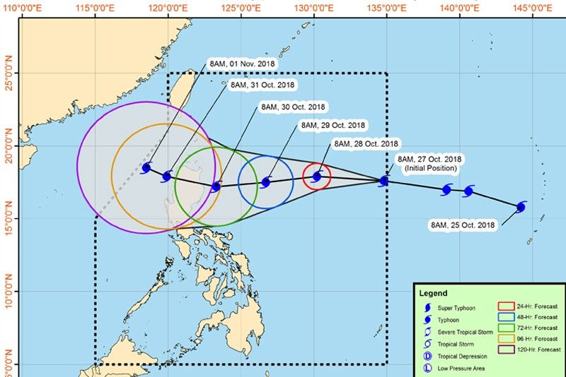
Forecast position:
- 24 Hour(Tomorrow morning): 905 km East of Aparri, Cagayan(17.9°N, 130.2°E)
- 48 Hour(Monday morning):545 km East of Aparri, Cagayan(17.5°N, 126.7°E)
- 72 Hour(Tuesday morning): 175 km East Southeast of Tuguegarao City, Cagayan(17.2°N, 123.3°E)
- 96 Hour(Wednesday morning):65 km Northwest of Sinait, Ilocos Sur(17.9°N, 119.9°E)
- 120 Hour(Thursday morning):225 km West of Laoag City, Ilocos Norte(18.5°N, 118.5°E)
— Ian Nicolas Cigaral


- Latest
- Trending