Nina to make Christmas landfall
As of 4 p.m. yesterday, the Philippine Atmospheric, Geophysical and Astronomical Services Administration (PAGASA) spotted the storm at about 1,320 kilometers east of northern Mindanao, moving west-northwest at a speed of 23 kilometers per hour. Screengrab from pagasa.dost.gov.ph
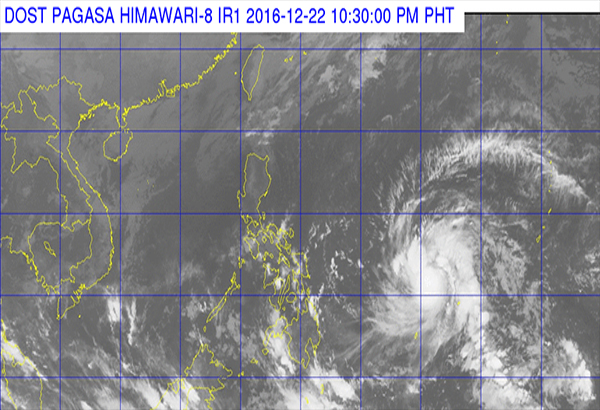
MANILA, Philippines - Tropical depression Nock-Ten intensified into a storm early yesterday, and was forecast to enter the Philippine area of responsibility as Tropical Storm Nina late last night or early today.
As of 4 p.m. yesterday, the Philippine Atmospheric, Geophysical and Astronomical Services Administration (PAGASA) spotted the storm at about 1,320 kilometers east of northern Mindanao, moving west-northwest at a speed of 23 kilometers per hour.
Packing maximum sustained winds of up to 75 kph and gustiness of up to 95 kph as of 4 p.m., the storm was projected to make landfall in the Bicol-Samar area, bringing rains in most parts of the country on Christmas Eve and Christmas Day.
Weather forecasters said the storm might further intensify as it is still above water, warning residents in its path to prepare for heavy downpour.
The Philippine Coast Guard (PCG) warned sea passengers yesterday to take note of PAGASA’s warning signals, saying vessels might not be allowed to sail in the typhoon’s path even on Christmas Day.
Albay, meanwhile, is bracing for a worst-case typhoon scenario, with Gov. Al Francis Bichara declaring a state of calamity in the province today to gear up for massive preparation and evacuation.
The weather bureau said the eastern part of the Visayas and Mindanao – particularly Eastern Visayas, Caraga and Davao regions – will experience cloudy skies with light to moderate rainshowers and thunderstorms due to the northeast monsoon.
“Partly cloudy to cloudy skies with isolated light rains are expected over the regions of Ilocos, Cordillera and Cagayan Valley,” PAGASA said.
“Partly cloudy to cloudy skies will prevail over Metro Manila and the rest of the country with isolated rainshowers or thunderstorms, mostly over the eastern section,” it added.
The weather bureau said moderate to strong winds blowing from the northeast would prevail over northern Luzon, with its coastal waters expected to be moderate to occasionally rough.
Some vessels not sailing this Yuletide
The PCG said yesterday it might not allow some vessels to sail even during the rush hours of Christmas time if PAGASA raises storm signals in some areas because of Tropical Storm Nina.
The PCG said it would depend on where PAGASA would hoist the public storm warning signals, advising sea passengers going home for Christmas of possibly getting stuck at port.
“We would like to warn our passengers to take caution of this,” PCG officer-in-charge Commodore Joel Garcia said. “Before they travel, they should take into consideration that the typhoon, more or less, (will affect) the Visayas and Mindanao. So they have to look into this. It depends if the area is supposed to be in the typhoon path, normally the Philippine Coast Guard, if it is even under PAGASA’s signal No. 1, we do not allow the vessel to sail,” he added.
Tropical Storm Nina is expected to hit, among other areas, Matnog in Sorsogon, Allen in Samar,and the provinces of Albay, Catanduanes, Batangas and Mindoro.
Garcia reminded sea passengers to be mindful of the storm’s location and sea condition.
“What is important is that they would be alerted by the warning and advisory, so they could prepare and decide on whether to travel tomorrow or let the typhoon pass and after that they could travel,” he said.
Albay braces for worse
Albay province is bracing for a worst-case scenario after weathermen presented typhoon models yesterday all indicating that Tropical Storm Niña would hit Bicol.
The governor announced in an emergency meeting of the Albay Disaster Risk Reduction Management Council (ADRRMC) the declaration of state of calamity in the province today to give way for the evacuation and massive preparations for the impact of the storm.
Bichara said the province is preparing for the worst, including up to 120 kph winds that could destroy structures made of light materials and generate up to seven feet storm surge; rainfall that could trigger floods, landslides and flashfloods with mudflow and debris.
He also ordered the different government agencies to start mobilizing their people and resources for pre-emptive evacuation and preposition of logistics and transport systems if the situation worsens.
Legazpi-based weatherman Ariel Zamudio said Tropical Storm Niña would hit Bicol, based on all three analyzed models. A model showed the storm would pass the Samar-Sorsogon-Masbate area, another would pass through Daet-Luzon and the other hit Samar-Sorsogon-Albay area.
Zamudio said Niña was expected to inter the Philippine area of responsibility late evening yesterday or early morning today, with winds at 65 kph and gustiness at 85 kph.
Zamudio said Niña might develop into a severe tropical storm packing winds of up to 120 kph when it makes landfall in Samar or Bicol.
“As of now, we do not see any weather system that could change drastically the storm’s direction that would spare Bicol region,” Zamudio told The STAR.
In a worst-case scenario, Albay is expected to evacuate at least 300,000 residents due to wind and heavy rainfall.
Albay last felt the brunt of a super typhoon in December 2006 when Reming left several hundreds dead or missing. – With Evelyn Macairan, Cet Dematera


- Latest
- Trending